1910s Maps of Hawaiʻi County, Hawaii
Explore 6 historic maps of Hawaiʻi County from the 1910s. These maps offer a rare glimpse into what life looked like during the 1910s — showing old roads, neighborhoods, homes, and landmarks that have changed or disappeared over time.
Whether you're researching your family's past, planning a metal detecting trip, or studying how Hawaiʻi County's landscape evolved across the 1910s, these high-resolution maps are a powerful tool for exploring the history of this region.
- Focus on a specific era: All maps on this page are from the 1910s, giving you a focused view of this time period.
- See what’s changed: Compare century-old streets, trails, and buildings to today's modern landscape using overlays and satellite layers.
- Research with precision: Use these maps for genealogy, historical research, land use analysis, or educational projects.
- View, download, or print: Maps are fully viewable online in high resolution, and can be downloaded or printed for your own records.
Start exploring Hawaiʻi County's history through authentic maps from the 1910s. This is your window into the past.
Hawaiʻi County, HI maps
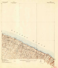
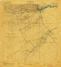
(6)- 1913 Map of Kohala, 1954 Print
 1913 Kohala1954 Print · USGSThe Kohala coast thrived as a hub of sugar production and rail transport during the early territory days. Genealogists and historians can trace the industrial landscape of Union Mill, the Hawaii Railway line, and cultural landmarks like Puukohola Heiau.
 - 1915 Map of Hamakua
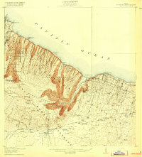
 1915 Hamakua1915 Print · USGSCoastal Hawaii at the height of its plantation era shows a landscape of steep gulches and industrial mills along the Hamakua coast. Genealogists and historians can locate specific family plots in the Ahualoa Homesteads or trace the Waimanu Flume and Paauilo Mill.3 unique versions available
 - 1915 Map of Honomu
 1915 Honomu1915 Print · USGSThe Hamakua and Hilo coastlines appear in incredible detail in this early territorial survey of Hawaii. Genealogists and historians can trace the foundations of plantation life at Honomu and Papaaloa, or locate long-standing landmarks like Akaka Falls and the Pohakupuka School.3 unique versions available
 - 1916 Map of Kohala
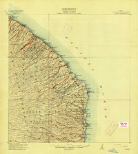
 1916 Kohala1916 Print · USGSThe northern tip of Hawaii island comes into focus during the height of the sugar era. Researchers can trace the industrial landscape of the Hawaii Railway connecting Union Mill, Hawi, and Kohala Mill to the coastal landings.2 unique versions available
 - 1916 Map of Waipio
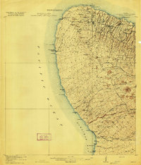
 1916 Waipio1916 Print · USGSThe Kohala coast and Hamakua district come alive in this early twentieth-century survey of the Big Island. Genealogists and historians can locate the Pacific Sugar Mill, the Halelua School, and the complex network of the Kohala Ditch.4 unique versions available
 - 1917 Map of Hilo
 1917 Hilo1917 Print · USGSThe Hilo region during the Great War era shows a landscape shaped by sugar production and volcanic history. Researchers can trace the Hilo R. R. through plantation hubs like Olaa Plantation Mill and early settlements including Mountain View and Elevenmile Homestead.
End of results
Showing maps 1-6 of 6
Top cities of Hawaiʻi County
Frequently asked questions
- What are the different types of historical maps available for Hawaiʻi County?
- What is the oldest map of Hawaiʻi County?
- Where can I purchase historical maps of Hawaiʻi County for my home or office?
- Where can I download high-res historical maps of Hawaiʻi County?
- Are there historical topographic maps available for Hawaiʻi County?
- Is there historical aerial imagery available for Hawaiʻi County?
- Where are historical maps of Hawaiʻi County sourced from?