1980s Maps of Blaine County, Idaho
Explore 12 historic maps of Blaine County from the 1980s. These maps offer a rare glimpse into what life looked like during the 1980s — showing old roads, neighborhoods, homes, and landmarks that have changed or disappeared over time.
Whether you're researching your family's past, planning a metal detecting trip, or studying how Blaine County's landscape evolved across the 1980s, these high-resolution maps are a powerful tool for exploring the history of this region.
- Focus on a specific era: All maps on this page are from the 1980s, giving you a focused view of this time period.
- See what’s changed: Compare century-old streets, trails, and buildings to today's modern landscape using overlays and satellite layers.
- Research with precision: Use these maps for genealogy, historical research, land use analysis, or educational projects.
- View, download, or print: Maps are fully viewable online in high resolution, and can be downloaded or printed for your own records.
Start exploring Blaine County's history through authentic maps from the 1980s. This is your window into the past.
Blaine County, ID maps
(12)- 1984 Map of Gifford Spring
 1984 Gifford Spring1984 Print · USGSSouthern Idaho in the mid-1980s reveals a rugged boundary between ancient lava beds and vital river habitats. Researchers can trace the isolated outposts of Wapi and DeWoff or explore the wetlands of Lake Walcott and the Minidoka National Wildlife Refuge.
 - 1984 Map of North Chapin Mountain
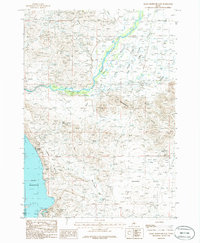
 1984 North Chapin Mountain1984 Print · USGSSouthern Idaho in the mid-1980s reveals a high-desert landscape defined by historic trails and modern water management. Trace the path of the Emigrant Trail as it skirts the Raft River Valley and the shores of Lake Walcott.
 - 1984 Map of Lake Walcott West
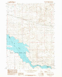
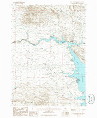
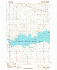 1984 Lake Walcott West1984 Print · USGSThe Snake River corridor in the mid-1980s reveals a landscape defined by massive water management and wildlife protection. Researchers can trace the engineering of the Power Plant and irrigation via the Main North Side Canal near Lake Walcott.
 - 1984 Map of Lake Walcott SE
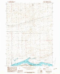
 1984 Lake Walcott SE1984 Print · USGSSouthern Idaho in the mid-1980s is defined here by the meeting of the Snake River and the Raft River near the border of Cassia and Blaine counties. Researchers can trace the path of the historic Emigrant Trail or study the wetlands of the Minidoka National Wildlife Refuge.
 - 1984 Map of Lake Walcott East
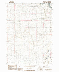
 1984 Lake Walcott East1984 Print · USGSThe Snake River plain meets the volcanic desert in the mid-1980s, revealing a landscape defined by conservation and geology. Researchers can trace the shoreline of Lake Walcott, locate the settlement of DeWolff, and explore the margins of the Wapi Flow.
 - 1986 Map of Bellevue
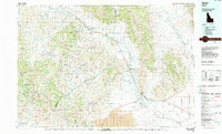
 1986 Bellevue1986 Print · USGSBellevue and the Wood River Valley are captured here in the mid-1980s, showcasing a landscape shaped by both ranching and mountain mining. Researchers can trace the legacy of local extraction through Minnie Moore Gulch, find the old settlement of Broadford, or locate family-named features like Mabelle Hill.2 unique versions available
 - 1986 Map of Beaver Creek
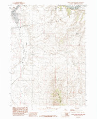
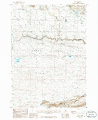
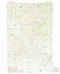 1986 Beaver Creek1986 Print · USGSThe high peaks of the Soldier Mountains meet the Camas Prairie in the mid-1980s, revealing a landscape of remote resource exploration. Researchers can trace numerous mountain prospect sites and four-wheel-drive trails near Beaver Creek and Square Mountain.
 - 1986 Map of Richardson Summit
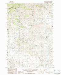 1986 Richardson Summit1986 Print · USGSIdaho's high mountain terrain and mineral history are captured in the mid-1980s near the border of the Sawtooth range. Metal detectorists and local historians can trace numerous Prospects and old routes near Doniphan and the Hailey Gold Belt Gulch.
 - 1986 Map of Magic Reservoir West
 1986 Magic Reservoir West1986 Print · USGSCamas County and Blaine County meet at the edge of the Magic Reservoir in the mid-1980s. Local researchers can trace the footprint of leisure and industry through Moonstone Landing, the Abandoned Railroad, and the remote Magic Resort.
 - 1986 Map of Magic Reservoir East
 1986 Magic Reservoir East1986 Print · USGSThe Big Wood River valley and the eastern edge of Magic Reservoir are captured here in the mid-1980s. Local historians and land researchers can trace the roads near Magic City, locate several Prospects, and explore named terrain like Rattlesnake Butte.
 - 1986 Map of Macon
 1986 Macon1986 Print · USGSCamas County is captured during the mid-1980s, showing the agricultural rhythm and changing transportation of the high Idaho plains. Trace the route of the Abandoned Railroad through Macon or locate local landmarks like Kelly Reservoir and Chicken Spring.
 - 1988 Map of Arco, 1989 Print
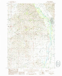
 1988 Arco1989 Print · USGSThe Big Lost River Valley thrived as a high-altitude ranching and agricultural hub in the late eighties. Researchers can trace the Union Pacific line to Arco or locate smaller rural communities like Houston, Moore, and Butte City.
End of results
Showing maps 1-12 of 12
Top cities of Blaine County
- Hailey historical maps
- Ketchum historical maps
- Bellevue historical maps
- Sun Valley historical maps
- Carey historical maps
Frequently asked questions
- What are the different types of historical maps available for Blaine County?
- What is the oldest map of Blaine County?
- Where can I purchase historical maps of Blaine County for my home or office?
- Where can I download high-res historical maps of Blaine County?
- Are there historical topographic maps available for Blaine County?
- Is there historical aerial imagery available for Blaine County?
- Where are historical maps of Blaine County sourced from?