1970s Maps of Caribou County, Idaho
Explore 5 historic maps of Caribou County from the 1970s. These maps offer a rare glimpse into what life looked like during the 1970s — showing old roads, neighborhoods, homes, and landmarks that have changed or disappeared over time.
Whether you're researching your family's past, planning a metal detecting trip, or studying how Caribou County's landscape evolved across the 1970s, these high-resolution maps are a powerful tool for exploring the history of this region.
- Focus on a specific era: All maps on this page are from the 1970s, giving you a focused view of this time period.
- See what’s changed: Compare century-old streets, trails, and buildings to today's modern landscape using overlays and satellite layers.
- Research with precision: Use these maps for genealogy, historical research, land use analysis, or educational projects.
- View, download, or print: Maps are fully viewable online in high resolution, and can be downloaded or printed for your own records.
Start exploring Caribou County's history through authentic maps from the 1970s. This is your window into the past.
Caribou County, ID maps
(5)- 1970 Map of Fossil Canyon, 1973 Print
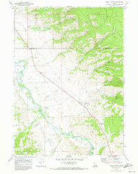 1970 Fossil Canyon1973 Print · USGSSoutheast Idaho in the early seventies shows a landscape defined by the Bear River and the transit corridor of the Union Pacific. Trace industrial sites like the Ship Mine or find the high terrain of Georgetown Summit and Manson.
 - 1970 Map of Harrington Peak, 1973 Print
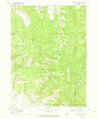 1970 Harrington Peak1973 Print · USGSThe Caribou National Forest backcountry comes into focus in this 1970 survey of the Idaho highlands. Genealogists and historians can trace industrial mining sites like the Slug Mine or find family-named landmarks such as Hess Park and Harrington Peak.2 unique versions available
 - 1970 Map of Giraffe Creek, 1973 Print
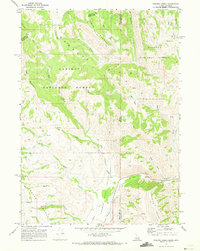 1970 Giraffe Creek1973 Print · USGSThe high-altitude border of Idaho and Wyoming is documented here in the 1970s as it was managed for water and forest resources. Researchers can trace the drainage of the Thomas Fork Valley and find irrigation landmarks like the Taylor Ditch and Thomas Fork Canal.
 - 1970 Map of Meade Peak, 1973 Print
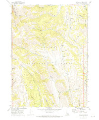 1970 Meade Peak1973 Print · USGSThe high backcountry of Southeast Idaho is captured here in the early seventies, detailing the remote ridges of the Preuss Range. Local historians and hikers can trace the old paths to the Giveout (Site) or navigate the drainages of Beaver Dam Creek and Bischoff Canyon.
 - 1978 Map of Blackfoot, 1997 Print
 1978 Blackfoot1997 Print · USGSThe Snake River Valley in the late 1970s shows a landscape of volcanic lava flows meeting intensive irrigation. Genealogists and local historians can trace the irrigation canals and rail towns from Atomic City to the Fort Hall Indian Reservation and Gay Mine.
End of results
Showing maps 1-5 of 5
Top cities of Caribou County
Frequently asked questions
- What are the different types of historical maps available for Caribou County?
- What is the oldest map of Caribou County?
- Where can I purchase historical maps of Caribou County for my home or office?
- Where can I download high-res historical maps of Caribou County?
- Are there historical topographic maps available for Caribou County?
- Is there historical aerial imagery available for Caribou County?
- Where are historical maps of Caribou County sourced from?