Old Maps of Caribou County, Idaho for Academic Research
Study the evolution of Caribou County with 348 high-resolution historic maps. Whether you're teaching, researching, or modeling changes in land use, these maps provide essential visual documentation of urban, environmental, and geographic change.
- Analyze long-term change: Track patterns in development, transportation, and natural features.
- Ideal for environmental or urban studies: Support academic projects with primary historical map data.
- Use in the classroom or lab: Educators and researchers rely on these maps to bring historical context to life.
These maps are a powerful tool for teaching, research, and visualizing how Caribou County has changed over the decades.
Caribou County, ID maps
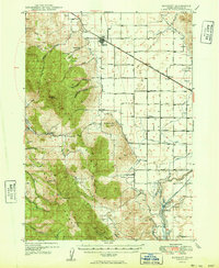
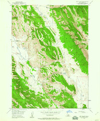
(348)- 1909 Map of Montpelier, 1957 Print
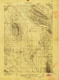
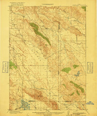
 1909 Montpelier1957 Print · USGSBear Lake County at the turn of the century shows a landscape defined by the arrival of the Oregon Short Line RR and early irrigation. Researchers can trace the original footprints of Montpelier and Paris or locate the historic Hot Springs Turnpike along the lake's eastern shore.
 - 1911 Map of Montpelier
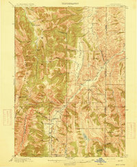
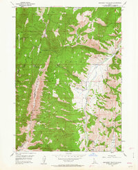
 1911 Montpelier1911 Print · USGSThe Bear Lake Valley at the start of the twentieth century was a vital rail and ranching corridor. Trace the Oregon Short Line RR through Montpelier and Paris, or locate early lakeside settlements like Fish Haven and St Charles.3 unique versions available
 - 1911 Map of Slug Creek, 1958 Print
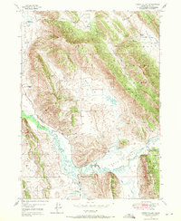
 1911 Slug Creek1958 Print · USGSSoutheast Idaho ranching and rail infrastructure are frozen in time just after the turn of the century. Genealogists can trace family homesteads like Stark and Strong Ranch and Schmid's Ranch or follow the path of the Oregon Short Line Railroad.
 - 1914 Map of Henry
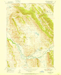
 1914 Henry1914 Print · USGSSoutheastern Idaho in the early twentieth century was a land of volcanic peaks and rising irrigation projects. Genealogists and local historians can trace the foundations of the ranching economy through Perkins Ranch, Chubb Springs, and the then-new Blackfoot River Reservoir.2 unique versions available
 - 1915 Map of Preston
 1915 Preston1915 Print · USGSSoutheastern Idaho and northern Utah are defined by their river valleys and early irrigation networks during the mid-1910s. Genealogists can locate family landmarks like the Thatcher Meetinghouse, Egypt School, and the path of the Oregon Short Line.2 unique versions available
 - 1915 Map of Freedom
 1915 Freedom1915 Print · USGSThe Idaho-Wyoming border comes alive in this survey of the high mountain ranges and irrigated valleys during the early twentieth century. Researchers can trace the path of the Lander Cutoff and locate early community landmarks like the Freedom School or the Old Salt Works.3 unique versions available
 - 1915 Map of Crow Creek
 1915 Crow Creek1915 Print · USGSThe high-desert ranching and salt industries of the Idaho-Wyoming border are captured here just before World War I. Researchers can locate early family homesteads like Cozzens Ranch and Books Ranch, or trace the operations at the Old Salt Works.3 unique versions available
 - 1915 Map of Lanes Creek, 1948 Print
 1915 Lanes Creek1948 Print · USGSCaribou County ranching and trail history are preserved in this pre-war survey of the Idaho high country. Researchers can trace the Landers Cutoff emigrant route past Lanes Grave or locate early settlements like Wayan and Williamsburg.2 unique versions available
 - 1916 Map of Henry
 1916 Henry1916 Print · USGSBannock County ranching and water engineering are on display here in the years just after the reservoir was filled. Genealogists and local historians can trace early family outposts like Perkins Ranch, the settlement at Henry, and the volcanic landmark China Hat.2 unique versions available
 - 1917 Map of Portneuf
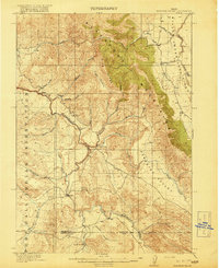
 1917 Portneuf1917 Print · USGSHigh mountain ridges and irrigation canals define this Idaho valley during the First World War era. Researchers can trace the early layout of Chesterfield, the local Goech School, and the path of the Oregon Short Line railroad.3 unique versions available
 - 1917 Map of Cranes Flat
 1917 Cranes Flat1917 Print · USGSSoutheast Idaho's high-plateau ranching country is shown here just before the First World War, where mountain ranges separate wide, arid basins. Researchers can locate the early Hancock Ranch and trace the original shoreline of the Blackfoot River Reservoir and Cranes Creek.3 unique versions available
 - 1918 Map of Preston
 1918 Preston1918 Print · USGSSouthern Idaho and northern Utah are captured just before the close of the Great War, showing a landscape of burgeoning farm towns and irrigation canals. Researchers can trace the Oregon Short Line to early settlements like Preston or locate rural landmarks like the Thatcher Meetinghouse and Egypt School.2 unique versions available
 - 1918 Map of Paradise Valley
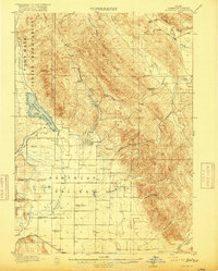
 1918 Paradise Valley1918 Print · USGSSouthern Idaho during the First World War era reveals a landscape defined by the Fort Hall Indian Reservation and the high Blackfoot Mountains. Genealogists and local historians can locate early landmarks like Morgan, Aldridge, and the Austin Ranch nestled along the Blackfoot River.3 unique versions available
 - 1932 Map of Irwin
 1932 Irwin1932 Print · USGSThe Snake River corridor and the high mountain basins of eastern Idaho are captured here in the early 1930s. Researchers can trace early river crossings like Edwards Ferry or find small-community landmarks like Rainy Dale and Pumpkin Center Sch.2 unique versions available
 - 1935 Map of Irwin
 1935 Irwin1935 Print · USGSThe Idaho-Wyoming borderlands are captured here in the 1930s as the river economy and mountain ranching defined the region. Researchers can trace the early road networks and rural institutions from Edwards Ferry to local schools like Fidelity Sch and Blowout Sch.3 unique versions available
 - 1948 Map of Bancroft, 1963 Print
 1948 Bancroft1963 Print · USGSBancroft and the Gentile Valley are captured here during the post-war era of hydroelectric and agricultural expansion. Local historians can trace the irrigation canals and power plants along the Bear River, alongside vanished landmarks like the Telluride Sch and Leadville Mine.2 unique versions available
 - 1948 Map of Soda Springs, 1965 Print
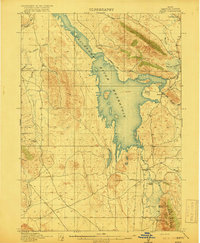
 1948 Soda Springs1965 Print · USGSSoda Springs and the surrounding Bear River valley are captured in the late 1940s, showing a landscape shaped by the historic Oregon Trail and modern industry. Genealogists and historians can locate the Grace Cem, Eightmile Sch, and the workings of the Conda Mine and Idaho Sulphur Mine (Aband).2 unique versions available
 - 1949 Map of Bancroft
 1949 Bancroft1949 Print · USGSBancroft and the Gentile Valley are captured here in the late 1940s, showing a landscape defined by the Union Pacific rail line and early hydroelectric power. Researchers can locate the Leadville Mine, the Telluride School, and numerous family-named landmarks like Kackley Spr and Barfuss Road.
 - 1949 Map of Soda Springs
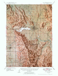 1949 Soda Springs1949 Print · USGSSoda Springs and the surrounding Bear River valley are captured in the late 1940s, a landscape defined by volcanic geology and phosphate mining. Researchers can locate specific pioneer-era sites like the Wagonbox Grave, Eightmile School, and the Conda Mine.4 unique versions available
 - 1949 Map of Johnson Creek, 1952 Print
 1949 Johnson Creek1952 Print · USGSCaribou County ranching and phosphate mining are captured here in the years following the war. Researchers can trace historic family holdings like Jougelard Ranch and Finlayson Ranch or locate the industrial G Portal (Conda Mine) near the Great Columbia River Divide.3 unique versions available
 - 1949 Map of Stewart Flat, 1960 Print
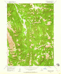 1949 Stewart Flat1960 Print · USGSThe Caribou National Forest in the late 1940s is shown as a backcountry landscape of timber and remote outposts. Trace the locations of the Smith Sawmill and the Johnson Guard Sta among landmarks like Draney Peak.2 unique versions available
 - 1949 Map of Dry Valley, 1960 Print
 1949 Dry Valley1960 Print · USGSCaribou County ranching life in the late 1940s is detailed here, showing a landscape of high ridges and remote valley outposts. Genealogists and researchers can trace family-named locations such as Knudsen Ranch, Bitton Ranch, and the Dry Valley Guard Sta.3 unique versions available
 - 1949 Map of Snowdrift Mountain, 1963 Print
 1949 Snowdrift Mountain1963 Print · USGSCaribou and Bear Lake counties were defined by remote ranching outposts and high forest divides during the late 1940s. Researchers can locate family-named sites like Nate Ranch and Allemans Ranch or trace the Great Basin Divide across Snowdrift Mountain.3 unique versions available
 - 1949 Map of Lower Valley, 1971 Print
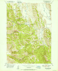
 1949 Lower Valley1971 Print · USGSCaribou County ranching and the high-country river systems are captured here as they appeared at the end of the 1940s. Genealogists and local historians can trace the locations of family-held lands such as Allen Ranch and Strong Ranch along the Blackfoot River.3 unique versions available
 - 1951 Map of Lower Valley
 1951 Lower Valley1951 Print · USGSCaribou County ranching life is well-documented in the early fifties as the Blackfoot River cuts through the high valleys. Researchers can locate specific family operations like the Stocking Ranch, Fox Ranch, and Strong Ranch along the local trails.
Showing maps 1-25 of 348
Top cities of Caribou County
Frequently asked questions
- What are the different types of historical maps available for Caribou County?
- What is the oldest map of Caribou County?
- Where can I purchase historical maps of Caribou County for my home or office?
- Where can I download high-res historical maps of Caribou County?
- Are there historical topographic maps available for Caribou County?
- Is there historical aerial imagery available for Caribou County?
- Where are historical maps of Caribou County sourced from?