1950s Maps of Caribou County, Idaho
Explore 15 historic maps of Caribou County from the 1950s. These maps offer a rare glimpse into what life looked like during the 1950s — showing old roads, neighborhoods, homes, and landmarks that have changed or disappeared over time.
Whether you're researching your family's past, planning a metal detecting trip, or studying how Caribou County's landscape evolved across the 1950s, these high-resolution maps are a powerful tool for exploring the history of this region.
- Focus on a specific era: All maps on this page are from the 1950s, giving you a focused view of this time period.
- See what’s changed: Compare century-old streets, trails, and buildings to today's modern landscape using overlays and satellite layers.
- Research with precision: Use these maps for genealogy, historical research, land use analysis, or educational projects.
- View, download, or print: Maps are fully viewable online in high resolution, and can be downloaded or printed for your own records.
Start exploring Caribou County's history through authentic maps from the 1950s. This is your window into the past.
Caribou County, ID maps
(15)- 1951 Map of Lower Valley
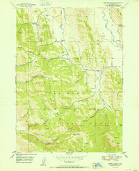
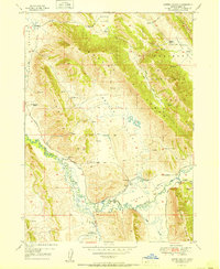 1951 Lower Valley1951 Print · USGSCaribou County ranching life is well-documented in the early fifties as the Blackfoot River cuts through the high valleys. Researchers can locate specific family operations like the Stocking Ranch, Fox Ranch, and Strong Ranch along the local trails.
 - 1951 Map of Upper Valley
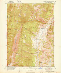
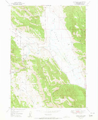 1951 Upper Valley1951 Print · USGSSoutheast Idaho at the turn of the 1950s shows a landscape of high mountain ranges and cattle-grazing valleys. Researchers can trace the headwaters of the Blackfoot River past the Stocking Ranch, the Trail Guard Sta, and various early mining prospects.4 unique versions available
 - 1951 Map of Stewart Flat
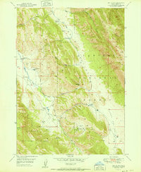
 1951 Stewart Flat1951 Print · USGSThe Idaho backcountry in the early fifties is defined by forest service outposts and mountain timber operations. Trace the roads to the Smith Sawmill, locate the Johnson Guard Sta, and find water sources like Lone Pine Spr.
 - 1951 Map of Dry Valley
 1951 Dry Valley1951 Print · USGSHigh-altitude Idaho ranching and mineral exploration are captured here at mid-century. Researchers can trace historic family holdings like the Sweet Ranch and Knudsen Ranch or locate the Dry Valley Guard Sta and various prospect sites.
 - 1951 Map of Snowdrift Mountain
 1951 Snowdrift Mountain1951 Print · USGSCaribou County and Bear Lake County meet in this high-altitude corner of Idaho during the early postwar years. Genealogists and historians can trace old homestead sites and forest stations like Nate Ranch, Allemans Ranch, and the Halfway House.
 - 1951 Map of Johnson Creek
 1951 Johnson Creek1951 Print · USGSCaribou County ranching and mining country are captured here in the early fifties as remote homesteads and mineral portals defined the landscape. Genealogists and historians can trace family-named sites like Jougelard Ranch, find the G Portal (Conda Mine), and locate backcountry water sources like Meadow Spr.
 - 1954 Map of Pocatello, 1963 Print
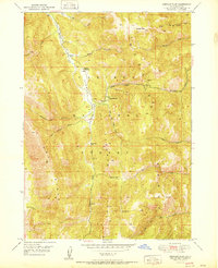
 1954 Pocatello1963 Print · USGSSoutheast Idaho in the mid-1950s reveals a landscape shaped by massive water reclamation and mountain forests. Researchers can trace the development of the Fort Hall Indian Reservation or locate specific landmarks like the Arbon P O and Emerson School.4 unique versions available
 - 1955 Map of Yandell Springs, 1957 Print
 1955 Yandell Springs1957 Print · USGSBingham County in the mid-1950s was a landscape of high-country springs and developing phosphate mines. Researchers can trace the Fort Hall Indian Reservation boundary, locate the Westvaco Mine, and find the Fort Hall No 2 Historic Site.
 - 1955 Map of Idaho Falls, 1963 Print
 1955 Idaho Falls1963 Print · USGSThe Snake River Plain and its surrounding volcanic peaks are captured in the late fifties, showing the region's unique mix of nuclear research and high-desert ranching. Trace the industrial footprint of the National Reactor Testing Station or find old mining sites like Empire Mine.5 unique versions available
 - 1955 Map of Driggs, 1967 Print
 1955 Driggs1967 Print · USGSEastern Idaho and Western Wyoming appear at a mid-century crossroads as the river valleys were fully settled and the high peaks protected. Genealogists and researchers can trace the rail towns of Rexburg and Driggs or follow the Snake River from Irwin to the Palisades Reservoir.3 unique versions available
 - 1955 Map of Preston, 1968 Print
 1955 Preston1968 Print · USGSSoutheast Idaho and western Wyoming are shown in detail during the mid-fifties, from the high Bear River Range to the Green River Basin. Genealogists and collectors can trace the Union Pacific RR through historic towns like Preston, Montpelier, and Afton.3 unique versions available
 - 1958 Map of Driggs
 1958 Driggs1958 Print · USGSThe high Teton peaks and Snake River valleys are captured here in the mid-fifties, showing the region's agricultural and wilderness boundaries. Researchers can trace the Union Pacific rail corridor through Rexburg or locate early settlements like Clementsville and Tetonia.2 unique versions available
 - 1958 Map of Idaho Falls
 1958 Idaho Falls1958 Print · USGSEastern Idaho in the late fifties showcases the rapid expansion of agricultural and scientific outposts across its volcanic plains. Researchers can locate remote sites like Atomic City, mineral interests at White Knob Mine, and the cultural grounds of St Marys Mission.2 unique versions available
 - 1958 Map of Pocatello
 1958 Pocatello1958 Print · USGSSoutheastern Idaho in the late fifties was a landscape of expanding reservoirs and historic trails. Genealogists and historians can trace the Old Oregon Trail, locate the Bannock Creek Indian Day School, and study the many Union Pacific rail sidings.2 unique versions available
 - 1958 Map of Preston
 1958 Preston1958 Print · USGSThe high valleys of the Idaho and Wyoming borderlands are captured here in the late fifties, showcasing a landscape of mountain ranching and phosphate mining. Genealogists and historians can locate early settlements like Chesterfield and Bedford or trace the Union Pacific rail lines serving Cokeville.2 unique versions available
End of results
Showing maps 1-15 of 15
Top cities of Caribou County
Frequently asked questions
- What are the different types of historical maps available for Caribou County?
- What is the oldest map of Caribou County?
- Where can I purchase historical maps of Caribou County for my home or office?
- Where can I download high-res historical maps of Caribou County?
- Are there historical topographic maps available for Caribou County?
- Is there historical aerial imagery available for Caribou County?
- Where are historical maps of Caribou County sourced from?