1940s Maps of Clearwater County, Idaho
Explore 2 historic maps of Clearwater County from the 1940s. These maps offer a rare glimpse into what life looked like during the 1940s — showing old roads, neighborhoods, homes, and landmarks that have changed or disappeared over time.
Whether you're researching your family's past, planning a metal detecting trip, or studying how Clearwater County's landscape evolved across the 1940s, these high-resolution maps are a powerful tool for exploring the history of this region.
- Focus on a specific era: All maps on this page are from the 1940s, giving you a focused view of this time period.
- See what’s changed: Compare century-old streets, trails, and buildings to today's modern landscape using overlays and satellite layers.
- Research with precision: Use these maps for genealogy, historical research, land use analysis, or educational projects.
- View, download, or print: Maps are fully viewable online in high resolution, and can be downloaded or printed for your own records.
Start exploring Clearwater County's history through authentic maps from the 1940s. This is your window into the past.
Clearwater County, ID maps
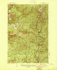
(2)- 1943 Map of Boehls Butte
 1943 Boehls Butte1943 Print · USGSThe Bitterroot Mountains of Northern Idaho are documented here during the mid-1940s, showing a rugged landscape managed for timber and fire protection. Genealogists and historians can locate remote mountain dwellings like Mix Cabin and prominent fire towers including Boehls Butte Lookout.2 unique versions available
 - 1944 Map of Headquarters
 1944 Headquarters1944 Print · USGSClearwater County timber operations and forest management are in full swing here during the mid-1940s. Researchers can locate remote outposts like Casey Cabin, trace the rail spurs at Cardiff Spur, and find early mining sites at the Democrat Mines.2 unique versions available
End of results
Showing maps 1-2 of 2
Top cities of Clearwater County
Frequently asked questions
- What are the different types of historical maps available for Clearwater County?
- What is the oldest map of Clearwater County?
- Where can I purchase historical maps of Clearwater County for my home or office?
- Where can I download high-res historical maps of Clearwater County?
- Are there historical topographic maps available for Clearwater County?
- Is there historical aerial imagery available for Clearwater County?
- Where are historical maps of Clearwater County sourced from?