1990s Maps of Clearwater County, Idaho
Explore 72 historic maps of Clearwater County from the 1990s. These maps offer a rare glimpse into what life looked like during the 1990s — showing old roads, neighborhoods, homes, and landmarks that have changed or disappeared over time.
Whether you're researching your family's past, planning a metal detecting trip, or studying how Clearwater County's landscape evolved across the 1990s, these high-resolution maps are a powerful tool for exploring the history of this region.
- Focus on a specific era: All maps on this page are from the 1990s, giving you a focused view of this time period.
- See what’s changed: Compare century-old streets, trails, and buildings to today's modern landscape using overlays and satellite layers.
- Research with precision: Use these maps for genealogy, historical research, land use analysis, or educational projects.
- View, download, or print: Maps are fully viewable online in high resolution, and can be downloaded or printed for your own records.
Start exploring Clearwater County's history through authentic maps from the 1990s. This is your window into the past.
Clearwater County, ID maps
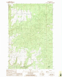
(72)- 1990 Map of Ahsahka, 1991 Print
 1990 Ahsahka1991 Print · USGSClearwater County at the start of the nineties shows a landscape defined by water management and public recreation. Researchers can trace the infrastructure of the Dworshak Dam and historic sites like the Lewis-Clark Canoe Camp State Park and Ahsahka.
 - 1990 Map of Bechtel Butte, 1991 Print
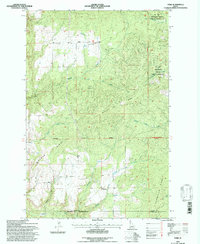
 1990 Bechtel Butte1991 Print · USGSThe timbered highlands of Northern Idaho are captured here as they appeared in the early 1990s at the intersection of three counties. Local historians can trace the headwaters of the St Maries River and locate features like the Race Track near Bechtel Butte.
 - 1990 Map of Mc Gary Butte, 1991 Print
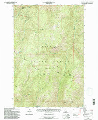
 1990 Mc Gary Butte1991 Print · USGSThe Latah and Clearwater county line passes through this Idaho mountain landscape in the 1990s. Trace old industrial footprints like the R.R. GRADE and MINE TUNNEL or locate the Latah Co Sheriff Posse Campground.
 - 1990 Map of Aldermand Ridge, 1991 Print
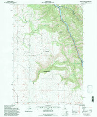
 1990 Aldermand Ridge1991 Print · USGSThe Idaho backcountry at the start of the nineties is detailed here, showing the timbered divide between Clearwater and Latah counties. Researchers can locate remote landmarks like the Mason Butte Lookout Tower, Round Meadows, and the recreational shoreline of the Dworshak Reservoir.
 - 1990 Map of Park, 1991 Print
 1990 Park1991 Print · USGSIn the Idaho Panhandle during the late twentieth century, the high plateau around Park remained a landscape of timbered ridges and deep gulches. Researchers can trace land patterns along the Boise Meridian and locate landmarks like Gold Hill and the Landing Strip.
 - 1990 Map of Southwick, 1991 Print
 1990 Southwick1991 Print · USGSNorth-central Idaho’s high-plateau farming and timber country is shown here in the late twentieth century, before modern development further altered the rural landscape. Researchers can locate family-named landmarks and essential local sites such as Southwick, the Teakean Cavendish Sch, and Potlatch Ridge.
 - 1994 Map of Weippe South, 1997 Print
 1994 Weippe South1997 Print · USGSThe Clearwater high country in the mid-1990s reveals a landscape defined by timbered ridges and the historic Lewis and Clark National Historic Trail. Researchers can trace the Nez Perce Indian Reservation Boundary and locate family-named points like Jacobson and Caribel.
 - 1994 Map of Rhodes Peak, 1997 Print
 1994 Rhodes Peak1997 Print · USGSThe Bitterroot mountains of the mid-1990s are mapped here at the height of their forest-management era along the Idaho-Montana line. Researchers can locate remote high-country landmarks like Rhodes Peak, the Black Lead mining area, and a lonely Grave near Billy Rhodes Creek.
 - 1994 Map of Pot Mountain, 1997 Print
 1994 Pot Mountain1997 Print · USGSThe Clearwater National Forest in the mid-1990s was a landscape of high ridges and active river corridors. Modern researchers can trace the intersection of industry and wilderness at the Industrial Camp and the historic Fourth of July Pack Bridge along the river.
 - 1994 Map of Pinchot Butte, 1997 Print
 1994 Pinchot Butte1997 Print · USGSThe deep timberlands of Shoshone and Clearwater counties are shown in the 1990s as a maze of forest trails and river valleys. Trace the landscape from Pinchot Butte down to the Dworshak Reservoir, passing the Mary Mix Cabin (Site) and New Boehls.
 - 1994 Map of Elizabeth Lake, 1997 Print
 1994 Elizabeth Lake1997 Print · USGSClearwater County's high-country wilderness is documented here during the mid-1990s as it appeared within the Clearwater National Forest. You can trace remote trails and geographic landmarks like Elizabeth Lake, Cold Springs Peak, and the long spine of Pot Mtn Ridge.
 - 1994 Map of Park, 1997 Print
 1994 Park1997 Print · USGSThe Latah County timberlands are captured here in the mid-nineties during a period of active forest management. Genealogists and researchers can trace the rugged terrain surrounding Park and Crescent while locating landmarks like Gold Hill, the Landing Strip, and Norwegian Ridge.2 unique versions available
 - 1994 Map of Cook Mountain, 1997 Print
 1994 Cook Mountain1997 Print · USGSThe Clearwater National Forest comes alive in the mid-1990s, showcasing the high ridges and deep drainages of the Idaho backcountry. Researchers can locate remote sites like Magary Camp and trace the paths of Weitas Creek and Crater Meadows.
 - 1994 Map of Osier Ridge, 1997 Print
 1994 Osier Ridge1997 Print · USGSThe Idaho backcountry in the mid-1990s is captured here, showing the remote ridge-and-canyon systems of the Clearwater National Forest. Researchers can trace the Independence Trail and locate the historic Moose City (Site) or the isolated Green Grave near The Cedars.
 - 1994 Map of Weitas Butte, 1997 Print
 1994 Weitas Butte1997 Print · USGSThe Clearwater National Forest in the 1990s preserved a landscape of high ridges and historic routes through Idaho and Clearwater counties. Researchers can trace the Nee-Me-Poo (Historic) Trail and find remote sites like Portable Soup Camp and Weitas Meadows.
 - 1994 Map of Hoodoo Pass, 1997 Print
 1994 Hoodoo Pass1997 Print · USGSThe high Bitterroot divide between Idaho and Montana is captured here in the mid-1990s, where national forest boundaries meet at the crest. Researchers can trace the remote network of ridge roads and alpine waters, from the Radio Tower at Hoodoo Pass to the headwaters of the North Fork Clearwater River.
 - 1994 Map of Little Green Mountain, 1997 Print
 1994 Little Green Mountain1997 Print · USGSClearwater County's backcountry is captured here in the mid-1990s as the wilderness landscape adjusts to the presence of the Dworshak Reservoir. Outdoor researchers and historians can trace the topography near the Jericho Mine, Baldy, and the numerous creeks like Swamp Creek that feed the North Fork.
 - 1994 Map of Scurvy Mountain, 1997 Print
 1994 Scurvy Mountain1997 Print · USGSThe Idaho wilderness comes into focus in the mid-1990s, showcasing the high-country drainages of the Clearwater River basin. Trace backcountry access and forest history through the Scurvy Lookout, the Junction Creek Pack Bridge, and remote spots like Scurvy Lake.
 - 1994 Map of Chamberlain Mtn, 1997 Print
 1994 Chamberlain Mtn1997 Print · USGSShoshone and Clearwater counties are shown in the mid-1990s, where the high ridges of the Panhandle and North Central Idaho meet. Researchers can trace historical footprints at Klug Cabin, find the remote Clearwater Mine, and locate old mountain camps at Chamberlain Meadows.
 - 1994 Map of Anthony Peak, 1997 Print
 1994 Anthony Peak1997 Print · USGSThe high country of Shoshone and Clearwater counties is captured in the mid-nineties, showing a landscape of managed forests and alpine peaks. Researchers can trace the headwaters of the Potlatch River and locate remote landmarks like Anthony Peak and Telephone Booth Hill.
 - 1994 Map of Mc Gary Butte, 1997 Print
 1994 Mc Gary Butte1997 Print · USGSThe Latah and Clearwater county line in the mid-1990s reveals a high-country landscape of forest management and early industrial traces. Researchers can trace the winding Old RR Grade and locate features like the Neva Tunnel and the settlement of Kameron.
 - 1994 Map of Buzzard Roost, 1997 Print
 1994 Buzzard Roost1997 Print · USGSShoshone and Clearwater counties meet in this high-altitude wilderness in the mid-1990s, where National Forest boundaries converge. Researchers can locate remote backcountry landmarks like Chicadee Cabin, the Devils Pulpit, and the Little North Fork Clearwater River.
 - 1994 Map of Elk Creek Falls, 1997 Print
 1994 Elk Creek Falls1997 Print · USGSClearwater County's timber and reservoir country is captured here in the 1990s, where steep forest ridges meet the rising waters of the basin. Researchers can locate remote outposts like Five Corners and Old Camp Y or trace the drainage of Elk Creek Falls through the forest.
 - 1994 Map of Elk Butte, 1997 Print
 1994 Elk Butte1997 Print · USGSClearwater County's timber history is preserved here in the mid-1990s, where old logging outposts are still noted as archaeological points of interest. You can trace the locations of the Diamond Match Camp and Camp 43 or locate the Elk Butte Lookout.
 - 1994 Map of Sixmile Creek, 1997 Print
 1994 Sixmile Creek1997 Print · USGSThe northern reaches of the Nez Perce Indian Reservation are captured here in the mid-1990s as the landscape transitions toward the canyon floor. Researchers can trace the rugged drainage systems of Sixmile Creek and Fivemile Creek or locate local resource sites like the Gravel Pit.
Showing maps 1-25 of 72
Top cities of Clearwater County
Frequently asked questions
- What are the different types of historical maps available for Clearwater County?
- What is the oldest map of Clearwater County?
- Where can I purchase historical maps of Clearwater County for my home or office?
- Where can I download high-res historical maps of Clearwater County?
- Are there historical topographic maps available for Clearwater County?
- Is there historical aerial imagery available for Clearwater County?
- Where are historical maps of Clearwater County sourced from?