1900s (20th Century) Maps of Custer County, Idaho
Explore 171 historic maps of Custer County from the 1900s (20th Century). These maps offer a rare glimpse into what life looked like during the 1900s — showing old roads, neighborhoods, homes, and landmarks that have changed or disappeared over time.
Whether you're researching your family's past, planning a metal detecting trip, or studying how Custer County's landscape evolved across the 1900s, these high-resolution maps are a powerful tool for exploring the history of this region.
- Focus on a specific era: All maps on this page are from the 1900s, giving you a focused view of this time period.
- See what’s changed: Compare century-old streets, trails, and buildings to today's modern landscape using overlays and satellite layers.
- Research with precision: Use these maps for genealogy, historical research, land use analysis, or educational projects.
- View, download, or print: Maps are fully viewable online in high resolution, and can be downloaded or printed for your own records.
Start exploring Custer County's history through authentic maps from the 1900s. This is your window into the past.
Custer County, ID maps
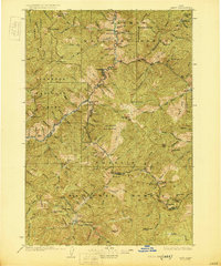
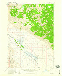
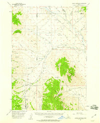
(171)- 1900 Map of Sawtooth
 1900 Sawtooth1900 Print · USGSThe high Idaho backcountry was a hub of hard-rock mining and remote outposts during the late 1890s. Genealogists and historians can trace the foundations of silver-era camps like Carrietown and Vienna or locate industrial sites like the Silver King Mine and Columbia Mill.4 unique versions available
 - 1919 Map of Custer, 1964 Print
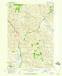
 1919 Custer1964 Print · USGSCuster County was a rugged hub of mining and forestry in the years following the Great War. Genealogists and historians can trace the early footprint of Custer, Bonanza, and the Sunbeam Mine, or locate the original Valley Creek Ranger Station.
 - 1922 Map of Custer
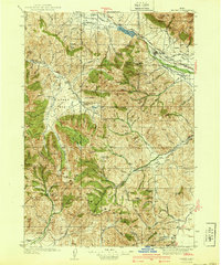
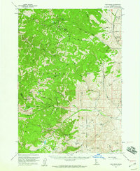
 1922 Custer1922 Print · USGSThe Salmon River high country comes alive in the years following the Great War, showing a landscape of isolated mining camps and early forest service outposts. Genealogists and researchers can trace the roads and trails connecting Custer, Bonanza, and the Sunbeam Mine.3 unique versions available
 - 1929 Map of Bayhorse, 1961 Print
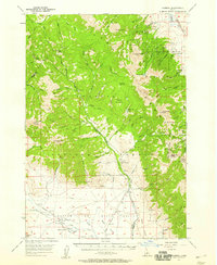
 1929 Bayhorse1961 Print · USGSCentral Idaho mining and ranching life are detailed in the late 1920s as mountain settlements like Bayhorse and Clayton thrived. Researchers can trace historic extraction sites like the Hecla Mine and Redbird Mine or locate the old East Fork Sch.
 - 1930 Map of Casto
 1930 Casto1930 Print · USGSCentral Idaho’s rugged backcountry in the late 1920s was a land of isolated mines and family ranches. Genealogists and historians can trace high-altitude mining at the Lost Packer Mine or locate early homesteads like Falconberry Ranch and Mormon Ranch.2 unique versions available
 - 1935 Map of MacKay
 1935 MacKay1935 Print · USGSCuster County was a rugged center of mining and irrigation in the mid-1930s. Genealogists and historians can trace high-altitude homesteads and industry through Mackay, the Star O Hope Mine, and rural schools like Franklin Sch.
 - 1935 Map of Borah Peak, 1959 Print
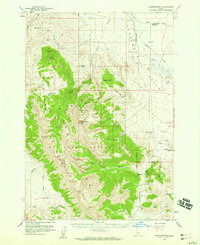
 1935 Borah Peak1959 Print · USGSCuster and Lemhi counties are shown during the mid-1930s, centering on the high peaks of the Lost River Range and the cattle country of the river valleys. Researchers can locate remote schools and stations such as Goldburg School, Dickey, and the Mahogany Ranger Station.
 - 1938 Map of Borah Peak
 1938 Borah Peak1938 Print · USGSCuster County ranching and high-mountain wilderness are captured here in the late 1930s, showing the early infrastructure of the Lost River Range. Genealogists and historians can trace isolated homesteads and rural landmarks like Goldburg School, Chilly, and the Pahsimeroi Ranger Station.2 unique versions available
 - 1940 Map of Mackay
 1940 Mackay1940 Print · USGSCuster and Butte counties are captured here in the late 1930s, showing a landscape defined by irrigation ditches and high-altitude mining. You can trace the development of the Big Lost River valley, finding early schools like Barton Sch and remote mountain sites like Leadbelt Mine.2 unique versions available
 - 1955 Map of Dubois
 1955 Dubois1955 Print · USGSThe high desert and mountain passes of eastern Idaho and western Montana are captured here during the mid-fifties. Researchers can trace the Union Pacific rail line through Dubois or locate the National Reactor Testing Station.4 unique versions available
 - 1955 Map of Idaho Falls, 1963 Print
 1955 Idaho Falls1963 Print · USGSThe Snake River Plain and its surrounding volcanic peaks are captured in the late fifties, showing the region's unique mix of nuclear research and high-desert ranching. Trace the industrial footprint of the National Reactor Testing Station or find old mining sites like Empire Mine.5 unique versions available
 - 1955 Map of Hailey, 1968 Print
 1955 Hailey1968 Print · USGSCentral Idaho in the mid-fifties reveals a landscape transitioning from deep-rooted silver mining to a burgeoning outdoor economy. Researchers can trace the legacy of the Union Pacific line, the remote Triumph Mine, and original airfield layouts at Mountain Home Air Force Base.4 unique versions available
 - 1956 Map of Donkey Hills, 1959 Print
 1956 Donkey Hills1959 Print · USGSThe Pahsimeroi Valley ranching country comes into focus in the mid-fifties as it sits between the high Lemhi and Lost River ranges. Local researchers can trace the old Goldburg settlement and Goldburg Sch alongside family homesteads like Lone Pine Ranch.2 unique versions available
 - 1956 Map of Doublespring, 1959 Print
 1956 Doublespring1959 Print · USGSThe high Pahsimeroi Valley and its surrounding peaks appear here in the mid-1950s, a landscape defined by ranching and high-altitude wilderness. Locate the Doublespring Ranch and trace rugged tracks to Grouse Creek Lake or Carlson Lake.2 unique versions available
 - 1956 Map of May, 1959 Print
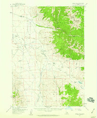
 1956 May1959 Print · USGSThe Pahsimeroi Valley of the mid-1950s is captured here as a remote ranching hub between the Lemhi and Lost River ranges. Researchers can trace the small settlement at May, its local Cemetery, and the Landing Strip serving this high-mountain basin.2 unique versions available
 - 1956 Map of Challis, 1960 Print
 1956 Challis1960 Print · USGSThe Salmon River valley comes into focus during the mid-1950s, showing the settlement of Challis and its vital mountain infrastructure. Researchers can trace local landmarks like Beardsley Hot Springs, the Challis Airfield, and family-named routes such as Burstadt Lane.2 unique versions available
 - 1956 Map of Twin Peaks, 1960 Print
 1956 Twin Peaks1960 Print · USGSCuster and Lemhi counties are captured in the mid-1950s, a period defined by high-country lookouts and primitive backcountry trails. Researchers can trace historic access points and water resources like White Goat Lookout, Mosquito Flat Reservoir, and the prospects near Big Hill Gulch.2 unique versions available
 - 1957 Map of Gilmore, 1958 Print
 1957 Gilmore1958 Print · USGSEastern Idaho’s mining and forest boundaries are clearly defined in the late fifties, centered on the high Lemhi Range. Genealogists and historians can trace the steep paths to the Latest Out Mine, the settlement of Gilmore, and the Fairview Guard Station.3 unique versions available
 - 1957 Map of Hawley Mountain, 1959 Print
 1957 Hawley Mountain1959 Print · USGSHigh mountain peaks and arid valley basins define this Idaho backcountry in the late fifties. Genealogists and historians can trace high-altitude routes like Pass Creek Road through the Challis National Forest and locate seasonal landmarks such as Magpie Springs and Mulkey Bar.2 unique versions available
 - 1957 Map of Challis, 1964 Print
 1957 Challis1964 Print · USGSCentral Idaho in the late fifties and early sixties remains a territory of remote mining camps and high-mountain ranger stations. Trace historic mining operations like the Lucky Boy Mine or locate isolated homesteads including Robinson Bar Ranch and Allison Ranch.3 unique versions available
 - 1958 Map of Dubois
 1958 Dubois1958 Print · USGSThe high divide between Idaho and Montana comes alive in this mid-century survey, from the mining camps of the Lemhi Range to the ranchlands of Centennial Valley. Trace historic operations at the Copper Queen Mine, the route of the Union Pacific RR, and the scientific work at the Sheep experimental station.2 unique versions available
 - 1958 Map of Idaho Falls
 1958 Idaho Falls1958 Print · USGSEastern Idaho in the late fifties showcases the rapid expansion of agricultural and scientific outposts across its volcanic plains. Researchers can locate remote sites like Atomic City, mineral interests at White Knob Mine, and the cultural grounds of St Marys Mission.2 unique versions available
 - 1959 Map of Hailey
 1959 Hailey1959 Print · USGSThe Sawtooth range and high desert plains of Southern Idaho are captured here during a period of mining and military growth. Genealogists and historians can locate mining sites like Triumph Mine, early settlements such as Idaho City, and the Mountain Home Air Force Base.2 unique versions available
 - 1960 Map of Challis
 1960 Challis1960 Print · USGSCentral Idaho’s high backcountry is detailed here in the early sixties, showing the remote ranching and mining life across five national forests. Genealogists and researchers can trace family holdings at the Silva Ranch or Jones Ranch and find historic sites like Redfish Lake Lodge and Clayton.
 - 1960 Map of Muldoon Canyon, 1961 Print
 1960 Muldoon Canyon1961 Print · USGSThe Pioneer Mountains during the early sixties were a landscape defined by high-altitude mining and national forest management. Trace the legacy of extraction at the Muldoon site, the Idaho Muldoon Mine, and the Eagle Bird Mine.3 unique versions available
Showing maps 1-25 of 171
Top cities of Custer County
- Challis historical maps
- Mackay historical maps
- Stanley historical maps
- Clayton historical maps
- Tunnel Rock historical maps
Frequently asked questions
- What are the different types of historical maps available for Custer County?
- What is the oldest map of Custer County?
- Where can I purchase historical maps of Custer County for my home or office?
- Where can I download high-res historical maps of Custer County?
- Are there historical topographic maps available for Custer County?
- Is there historical aerial imagery available for Custer County?
- Where are historical maps of Custer County sourced from?