1930s Maps of Custer County, Idaho
Explore 4 historic maps of Custer County from the 1930s. These maps offer a rare glimpse into what life looked like during the 1930s — showing old roads, neighborhoods, homes, and landmarks that have changed or disappeared over time.
Whether you're researching your family's past, planning a metal detecting trip, or studying how Custer County's landscape evolved across the 1930s, these high-resolution maps are a powerful tool for exploring the history of this region.
- Focus on a specific era: All maps on this page are from the 1930s, giving you a focused view of this time period.
- See what’s changed: Compare century-old streets, trails, and buildings to today's modern landscape using overlays and satellite layers.
- Research with precision: Use these maps for genealogy, historical research, land use analysis, or educational projects.
- View, download, or print: Maps are fully viewable online in high resolution, and can be downloaded or printed for your own records.
Start exploring Custer County's history through authentic maps from the 1930s. This is your window into the past.
Custer County, ID maps
(4)- 1930 Map of Casto
 1930 Casto1930 Print · USGSCentral Idaho’s rugged backcountry in the late 1920s was a land of isolated mines and family ranches. Genealogists and historians can trace high-altitude mining at the Lost Packer Mine or locate early homesteads like Falconberry Ranch and Mormon Ranch.2 unique versions available
 - 1935 Map of MacKay
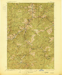
 1935 MacKay1935 Print · USGSCuster County was a rugged center of mining and irrigation in the mid-1930s. Genealogists and historians can trace high-altitude homesteads and industry through Mackay, the Star O Hope Mine, and rural schools like Franklin Sch.
 - 1935 Map of Borah Peak, 1959 Print
 1935 Borah Peak1959 Print · USGSCuster and Lemhi counties are shown during the mid-1930s, centering on the high peaks of the Lost River Range and the cattle country of the river valleys. Researchers can locate remote schools and stations such as Goldburg School, Dickey, and the Mahogany Ranger Station.
 - 1938 Map of Borah Peak
 1938 Borah Peak1938 Print · USGSCuster County ranching and high-mountain wilderness are captured here in the late 1930s, showing the early infrastructure of the Lost River Range. Genealogists and historians can trace isolated homesteads and rural landmarks like Goldburg School, Chilly, and the Pahsimeroi Ranger Station.2 unique versions available
End of results
Showing maps 1-4 of 4
Top cities of Custer County
- Challis historical maps
- Mackay historical maps
- Stanley historical maps
- Clayton historical maps
- Tunnel Rock historical maps
Frequently asked questions
- What are the different types of historical maps available for Custer County?
- What is the oldest map of Custer County?
- Where can I purchase historical maps of Custer County for my home or office?
- Where can I download high-res historical maps of Custer County?
- Are there historical topographic maps available for Custer County?
- Is there historical aerial imagery available for Custer County?
- Where are historical maps of Custer County sourced from?