1900s (20th Century) Maps of Mountain Home, Idaho
Explore 9 historic maps of Mountain Home from the 1900s (20th Century). These maps offer a rare glimpse into what life looked like during the 1900s — showing old roads, neighborhoods, homes, and landmarks that have changed or disappeared over time.
Whether you're researching your family's past, planning a metal detecting trip, or studying how Mountain Home's landscape evolved across the 1900s, these high-resolution maps are a powerful tool for exploring the history of this region.
- Focus on a specific era: All maps on this page are from the 1900s, giving you a focused view of this time period.
- See what’s changed: Compare century-old streets, trails, and buildings to today's modern landscape using overlays and satellite layers.
- Research with precision: Use these maps for genealogy, historical research, land use analysis, or educational projects.
- View, download, or print: Maps are fully viewable online in high resolution, and can be downloaded or printed for your own records.
Start exploring Mountain Home's history through authentic maps from the 1900s. This is your window into the past.
Mountain Home, ID maps
(9)- 1955 Map of Hailey, 1968 Print
 1955 Hailey1968 Print · USGSCentral Idaho in the mid-fifties reveals a landscape transitioning from deep-rooted silver mining to a burgeoning outdoor economy. Researchers can trace the legacy of the Union Pacific line, the remote Triumph Mine, and original airfield layouts at Mountain Home Air Force Base.4 unique versions available
 - 1956 Map of Mountain Home South, 1957 Print
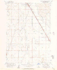 1956 Mountain Home South1957 Print · USGSElmore County's high desert landscape comes into focus during the mid-fifties, revealing a vital junction for Idaho's rail and road networks. Trace the historical layers of the Old Oregon Trail alongside older routes like the Freight Trail and the Old Lamberton Trail.3 unique versions available
 - 1956 Map of Mountain Home North, 1957 Print
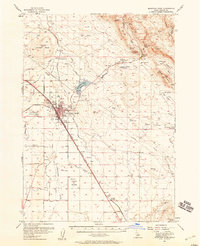
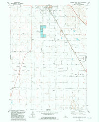
 1956 Mountain Home North1957 Print · USGSElmore County's development shines in the mid-1950s as a vital transportation and irrigation hub. You can trace the historic Old Oregon Trail Road alongside the Union Pacific Railroad and identify local landmarks like Mtn View Cemetery.3 unique versions available
 - 1956 Map of Mountain Home, 1958 Print
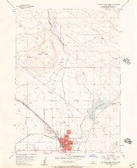
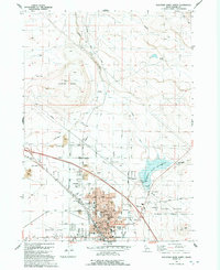
 1956 Mountain Home1958 Print · USGSMountain Home was a critical Idaho transport hub in the mid-fifties, where the railroad met historic western trails. Genealogists and local historians can trace family plots at Elmore Memorial Cemetery or locate the Oregon Trail Historical Marker near Teapot Basin.2 unique versions available
 - 1959 Map of Hailey
 1959 Hailey1959 Print · USGSThe Sawtooth range and high desert plains of Southern Idaho are captured here during a period of mining and military growth. Genealogists and historians can locate mining sites like Triumph Mine, early settlements such as Idaho City, and the Mountain Home Air Force Base.2 unique versions available
 - 1962 Map of Hailey
 1962 Hailey1962 Print · USGSCentral Idaho in the early sixties showcases a landscape of high-altitude ranching and mining at the foot of the Sawtooth Mountains. Genealogists and historians can trace the rail-and-river economy through the Union Pacific Railroad corridor and explore old mining sites like the Triumph Mine or Silver Star Queens Mine.
 - 1990 Map of Mountain Home, 1991 Print
 1990 Mountain Home1991 Print · USGSElmore County underwent significant expansion in the 1990s as military and transit networks matured between the mountains and the Snake River Plain. Researchers can trace the legacy of regional development through sites like Reclamation Village, the Union Pacific line, and Mountain Home Air Force Base.2 unique versions available
 - 1992 Map of Mountain Home South
 1992 Mountain Home South1992 Print · USGSElmore County's high-desert landscape comes into focus south of the city during the early nineties. Researchers can trace historical transit routes like Old Highway 30 and explore the boundaries of the Snake River Birds of Prey Area.
 - 1992 Map of Mountain Home North
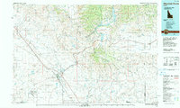
 1992 Mountain Home North1992 Print · USGSMountain Home had grown into a vital high-desert hub by the early nineties, balancing its civic center with the surrounding rangeland. Researchers can trace the historic Oregon Trail, locate family sites near the Mountain Home Cemetery, or study the Mountain Home Reservoir.
End of results
Showing maps 1-9 of 9
Frequently asked questions
- What are the different types of historical maps available for Mountain Home?
- What is the oldest map of Mountain Home?
- Where can I purchase historical maps of Mountain Home for my home or office?
- Where can I download high-res historical maps of Mountain Home?
- Are there historical topographic maps available for Mountain Home?
- Is there historical aerial imagery available for Mountain Home?
- Where are historical maps of Mountain Home sourced from?