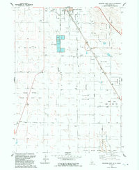
1992 Map of Mountain Home South
USGS Topo · Published 1992About this map
Mountain Home serves as the focal point of this high-desert landscape, where the southern reaches of the city extend toward the arid plateaus of Elmore County. The map details a transition from municipal infrastructure, such as the Sewage Disposal Ponds and various Trailer Parks, into an agricultural and conservation-focused backcountry. The southern half of the quadrangle is dominated by the Snake River Birds of Prey Area, a vast protected canyon environment that borders the agricultural developments of Clover Hollow and the level expanse of Slade Flat.
Find a feature on this map
24 named features on this map. Tap any name to fly to it.
Don’t see what you’re looking for? This feature index may not catch every label — zoom into the map to look around manually.
Map Details
Editions of this 1992 Mountain Home South Map
This is the sole edition of this map. No revisions or reprints were ever made.
Other maps of this area

1892 · Mountain Home
USGS Topo · 1:125,000

1893 · Mountain Home
USGS Topo · 1:125,000

1947 · Bruneau
USGS Topo · 1:62,500

1947 · Indian Cove
USGS Topo · 1:24,000

1947 · Sand Dunes
USGS Topo · 1:24,000

1947 · Bruneau
USGS Topo · 1:24,000

1948 · Sand Dunes
USGS Topo · 1:24,000

1948 · Indian Cove
USGS Topo · 1:24,000
1948 · Bruneau
USGS Topo · 1:24,000

1948 · Indian Cove
USGS Topo · 1:62,500