1920s Maps of Idaho County, Idaho
Explore 3 historic maps of Idaho County from the 1920s. These maps offer a rare glimpse into what life looked like during the 1920s — showing old roads, neighborhoods, homes, and landmarks that have changed or disappeared over time.
Whether you're researching your family's past, planning a metal detecting trip, or studying how Idaho County's landscape evolved across the 1920s, these high-resolution maps are a powerful tool for exploring the history of this region.
- Focus on a specific era: All maps on this page are from the 1920s, giving you a focused view of this time period.
- See what’s changed: Compare century-old streets, trails, and buildings to today's modern landscape using overlays and satellite layers.
- Research with precision: Use these maps for genealogy, historical research, land use analysis, or educational projects.
- View, download, or print: Maps are fully viewable online in high resolution, and can be downloaded or printed for your own records.
Start exploring Idaho County's history through authentic maps from the 1920s. This is your window into the past.
Idaho County, ID maps
(3)- 1922 Map of He Devil
 1922 He Devil1922 Print · USGSThe Seven Devils Mountains of the early 1920s reveal a landscape of remote mining claims and high-elevation ranching camps. Researchers can locate historical sites like the Winchester Mine, Mc Gaffees Ranch, and Jacks Cabin.
 - 1924 Map of Kamiah
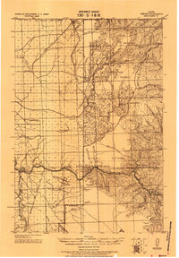
 1924 Kamiah1924 Print · USGSNorth-central Idaho settlements thrive along the Clearwater River and upland plateaus during the mid-twenties. Genealogists and historians can trace the paths of the Northern Pacific railroad through rail towns like Volmer, Cottonwood, and the river crossing at Kamiah.
 - 1924 Map of Weippe
 1924 Weippe1924 Print · USGSNorth-central Idaho in the early 1920s is captured here, from the prairie settlements to the deep river canyons of the Clearwater. Genealogists can trace early homesteaders like G.W. Ford or locate long-gone post offices at Tahoe and Lowell.
End of results
Showing maps 1-3 of 3
Top cities of Idaho County
- Grangeville historical maps
- Cottonwood historical maps
- Kooskia historical maps
- Riggins historical maps
- Stities historical maps
- Ferdinand historical maps
See more
Frequently asked questions
- What are the different types of historical maps available for Idaho County?
- What is the oldest map of Idaho County?
- Where can I purchase historical maps of Idaho County for my home or office?
- Where can I download high-res historical maps of Idaho County?
- Are there historical topographic maps available for Idaho County?
- Is there historical aerial imagery available for Idaho County?
- Where are historical maps of Idaho County sourced from?