1930s Maps of Clinton County, Illinois
Explore 4 historic maps of Clinton County from the 1930s. These maps offer a rare glimpse into what life looked like during the 1930s — showing old roads, neighborhoods, homes, and landmarks that have changed or disappeared over time.
Whether you're researching your family's past, planning a metal detecting trip, or studying how Clinton County's landscape evolved across the 1930s, these high-resolution maps are a powerful tool for exploring the history of this region.
- Focus on a specific era: All maps on this page are from the 1930s, giving you a focused view of this time period.
- See what’s changed: Compare century-old streets, trails, and buildings to today's modern landscape using overlays and satellite layers.
- Research with precision: Use these maps for genealogy, historical research, land use analysis, or educational projects.
- View, download, or print: Maps are fully viewable online in high resolution, and can be downloaded or printed for your own records.
Start exploring Clinton County's history through authentic maps from the 1930s. This is your window into the past.
Clinton County, IL maps
(4)- 1931 Map of Hoyleton
 1931 Hoyleton1931 Print · USGSWashington County at the start of the 1930s shows a landscape of busy crossroads and rail junctions. Genealogists can trace family roots through numerous local schoolhouses like Nuptial Sch and Hogshead Sch, or locate ancestors at the Masonic Cem.
 - 1932 Map of Nashville, 1960 Print
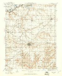 1932 Nashville1960 Print · USGSWashington and Clinton Counties come alive in the early thirties as a dense network of rail and rural schools. Genealogists can trace family roots through landmarks like Locust Creek Cem and dozens of local schoolhouses including Sassafras Sch and Hogshead Sch.2 unique versions available
 - 1935 Map of Centralia, 1958 Print
 1935 Centralia1958 Print · USGSCentralia and the surrounding Marion County townships thrived as a major railroad crossroads in the mid-1930s. Researchers can locate dozens of localized rural schoolhouses like Red Stripe and Possumtrot School or trace the early paths of the Illinois Central through Sandoval and Odin.
 - 1936 Map of Nashville
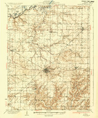 1936 Nashville1936 Print · USGSSouthern Illinois prairie life thrives at the crossroads of the river and rail in the mid-1930s. Genealogists can locate dozens of country schools and churches, from Hogshead Sch to Elkhorn Sch, and trace the path of the Louisville and Nashville Railroad.2 unique versions available
End of results
Showing maps 1-4 of 4
Top cities of Clinton County
- Breese historical maps
- Carlyle historical maps
- Trenton historical maps
- Aviston historical maps
- Germantown historical maps
- Beckemeyer historical maps
See more
Frequently asked questions
- What are the different types of historical maps available for Clinton County?
- What is the oldest map of Clinton County?
- Where can I purchase historical maps of Clinton County for my home or office?
- Where can I download high-res historical maps of Clinton County?
- Are there historical topographic maps available for Clinton County?
- Is there historical aerial imagery available for Clinton County?
- Where are historical maps of Clinton County sourced from?