Old Maps of Clinton County, Illinois for Metal Detecting
Plan your next treasure hunt with 99 historic maps of Clinton County. Find old homesites, ghost towns, trails, and gathering spots that may be lost to time — perfect for identifying promising metal detecting locations.
- Locate forgotten sites: Uncover places like long-lost settlements, abandoned rail lines, or gathering spots.
- Plan better hunts: Use map overlays combined with LiDAR or satellite views to narrow in on historically rich areas.
- Made for detectorists: Thousands of hobbyists use these maps to discover relics, coins, and hidden history.
Use these historic maps to boost your research and find new opportunities beneath the surface of Clinton County.
Clinton County, IL maps
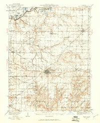
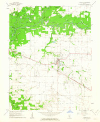
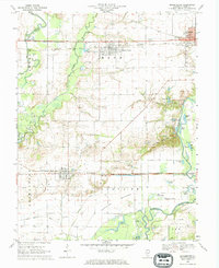
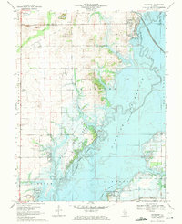
(99)- 1906 Map of Breese, 1958 Print
 1906 Breese1958 Print · USGSThe Illinois prairie east of St. Louis is shown here at the turn of the century, when rail lines and rural school districts formed the backbone of local life. Genealogy researchers can locate dozens of country schools like Linden School and Ruth School near established towns like Breese and Germantown.
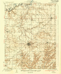
 - 1907 Map of Breese
 1907 Breese1907 Print · USGSClinton and St. Clair counties were a bustling network of rail-towns and rural school districts at the turn of the century. Researchers can trace ancestral property near dozens of family-named landmarks like Richter School, McKee School, or the small village of Damiansville.2 unique versions available
 - 1910 Map of Carlyle
 1910 Carlyle1910 Print · USGSClinton County and the Kaskaskia River valley are captured here at a peak of rural development in the Edwardian era. Genealogists can trace a dense network of family-named landmarks including Hull School, McKendree Chapel, and the river crossing at Colmers Ferry.2 unique versions available
 - 1910 Map of Okawville
 1910 Okawville1910 Print · USGSEastern St. Clair and Washington counties appear here in the early 1900s, where the winding river bottomlands met the expanding railroad. Local historians can trace the development of Okawville along the Louisville & Nashville RR or find rural landmarks like Stone Church and Woodland School.2 unique versions available
 - 1914 Map of Centralia
 1914 Centralia1914 Print · USGSSouthern Illinois at the peak of the rail era shows a landscape of busy junctions and tightly-knit rural school districts. Genealogists and historians can trace family locations near landmarks like Possumtrot School, Fikes Hill, and the bustling yards of Centralia.3 unique versions available
 - 1931 Map of Hoyleton
 1931 Hoyleton1931 Print · USGSWashington County at the start of the 1930s shows a landscape of busy crossroads and rail junctions. Genealogists can trace family roots through numerous local schoolhouses like Nuptial Sch and Hogshead Sch, or locate ancestors at the Masonic Cem.
 - 1932 Map of Nashville, 1960 Print
 1932 Nashville1960 Print · USGSWashington and Clinton Counties come alive in the early thirties as a dense network of rail and rural schools. Genealogists can trace family roots through landmarks like Locust Creek Cem and dozens of local schoolhouses including Sassafras Sch and Hogshead Sch.2 unique versions available
 - 1935 Map of Centralia, 1958 Print
 1935 Centralia1958 Print · USGSCentralia and the surrounding Marion County townships thrived as a major railroad crossroads in the mid-1930s. Researchers can locate dozens of localized rural schoolhouses like Red Stripe and Possumtrot School or trace the early paths of the Illinois Central through Sandoval and Odin.
 - 1936 Map of Nashville
 1936 Nashville1936 Print · USGSSouthern Illinois prairie life thrives at the crossroads of the river and rail in the mid-1930s. Genealogists can locate dozens of country schools and churches, from Hogshead Sch to Elkhorn Sch, and trace the path of the Louisville and Nashville Railroad.2 unique versions available
 - 1940 Map of Okawville, 1958 Print
 1940 Okawville1958 Print · USGSSouthwestern Illinois at the start of the 1940s remains a landscape of tight-knit farming hamlets and river-bottom wetlands. Researchers can trace the heritage of German settlements and rail stops from St Libory and Darmstadt to the mineral springs area of Okawville.
 - 1948 Map of Carlyle
 1948 Carlyle1948 Print · USGSCarlyle and the Kaskaskia River valley are captured in the late 1940s, showing a landscape of river-bend lakes and thriving rail towns. Researchers can trace the heritage of local families at McKendree Chapel, The Mound School, and the State Fish Hatchery.
 - 1957 Map of Highland, 1958 Print
 1957 Highland1958 Print · USGSHighland and the surrounding Madison County townships are captured here in the mid-1950s as a thriving rail-side community. Researchers can trace family history through local landmarks like St Joseph Cemetery, Sugar Creek Church, and the rural enclave of St Morgan.3 unique versions available
 - 1957 Map of Venedy, 1958 Print
 1957 Venedy1958 Print · USGSSouthern Illinois at the peak of the post-war era shows a landscape defined by the winding Kaskaskia River and the busy Louisville and Nashville railroad. Genealogists can trace the rural communities of Venedy and Johannishurg, or locate family landmarks like the Miller Cem and several oxbow lakes.2 unique versions available
 - 1957 Map of Trenton, 1958 Print
 1957 Trenton1958 Print · USGSThe border of St. Clair and Clinton counties was a hub of mid-century rail activity, centered on the growing communities of Trenton and New Baden. Genealogists and local historians can trace family plots at Harpstrite Cem or locate industrial sites like Knaus Quarry.2 unique versions available
 - 1958 Map of Belleville, 1973 Print
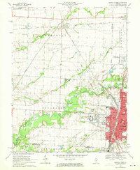
 1958 Belleville1973 Print · USGSSouthern Illinois during the mid-twentieth century reveals a landscape of industrial growth and massive new reservoirs. Genealogists and historians can trace the paths of the Illinois Central RR through towns like Centralia or locate landmarks such as Emerald Mound and the Looking Glass Prairie.3 unique versions available
 - 1962 Map of Belleville
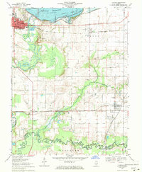
 1962 Belleville1962 Print · USGSSouthern Illinois in the late fifties reveals a landscape of industrial growth and ancient landmarks before the full expansion of the interstate system. Genealogists can trace family names and rural post offices near Centralia, Salem, and the historic Monks Mound.
 - 1962 Map of Okawville, 1963 Print
 1962 Okawville1963 Print · USGSWashington County during the early 1960s reveals a landscape defined by the winding Kaskaskia River and the steady commerce of the rail lines. Researchers can trace ancestral roots through numerous local landmarks like St Pauls Ch, Klasing Sch, and the IOOF Cem.2 unique versions available
 - 1962 Map of St. Rose, 1963 Print
 1962 St. Rose1963 Print · USGSThe rural borderlands of Clinton and Madison counties are captured here in the early sixties. Researchers can locate the Lake Branch Cemetery, the small cluster of Sebastopol, and early property lines near Shoal Creek.2 unique versions available
 - 1962 Map of Breese, 1963 Print
 1962 Breese1963 Print · USGSClinton County’s rural and rail landscape is captured here in the early sixties as small towns flourished along the dual rail lines. Genealogists and historians can trace family roots at St Dominics Cem, Damiansville, and the grounds of Mater Dei High Sch.2 unique versions available
 - 1968 Map of Stolletown, 1971 Print
 1968 Stolletown1971 Print · USGSClinton County during the late 1960s was a landscape where traditional farming met the growing energy industry and new water management projects. Researchers can locate family landmarks like St Peters Cem, the local Ford Sch, and the emerging Carlyle Reservoir.
 - 1969 Map of Beckemeyer, 1971 Print
 1969 Beckemeyer1971 Print · USGSClinton County thrived as a center for rail, oil, and river trade in the late sixties. Genealogists and local historians can trace family plots at Beckemeyer Cem or St Cecelias Cem while exploring the Bartelso Oil Field and river bottomlands.
 - 1969 Map of Boulder, 1971 Print
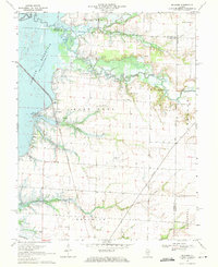 1969 Boulder1971 Print · USGSClinton County and the surrounding river bottoms are captured here in the late sixties as the newly formed Carlyle Reservoir altered the landscape. Genealogists can trace numerous family burial sites like Old Carter Cem and Hawkins Cem near the oil derricks of the Patoka Field.
 - 1969 Map of Centralia West, 1971 Print
 1969 Centralia West1971 Print · USGSCentralia and Wamac are shown at a peak of industrial and institutional growth in the late sixties. Researchers can trace family roots through numerous sites like Bethlehem Cem, Kaskaskia College, and the busy Junction City (Glen Ridge Station).2 unique versions available
 - 1969 Map of Carlyle, 1971 Print
 1969 Carlyle1971 Print · USGSClinton and Washington counties appear here in the late sixties as the local landscape was being redefined by large-scale water management and oil production. Researchers can trace family sites like Posey Cem and St Marys Sch alongside the active Huey South Oil Field and the Baltimore and Ohio rail corridor.
 - 1969 Map of Keyesport, 1971 Print
 1969 Keyesport1971 Print · USGSThe Kaskaskia River valley in the late sixties reveals a landscape shaped by the new reservoir and recreational growth. Genealogists and local historians can locate McKendree Cem, trace the Burlington Northern line, and see the Keyesport Oil Field.2 unique versions available
Showing maps 1-25 of 99
Top cities of Clinton County
- Breese historical maps
- Carlyle historical maps
- Trenton historical maps
- Aviston historical maps
- Germantown historical maps
- Beckemeyer historical maps
See more
Frequently asked questions
- What are the different types of historical maps available for Clinton County?
- What is the oldest map of Clinton County?
- Where can I purchase historical maps of Clinton County for my home or office?
- Where can I download high-res historical maps of Clinton County?
- Are there historical topographic maps available for Clinton County?
- Is there historical aerial imagery available for Clinton County?
- Where are historical maps of Clinton County sourced from?