1990s Maps of Charleston, Illinois
Explore 4 historic maps of Charleston from the 1990s. These maps offer a rare glimpse into what life looked like during the 1990s — showing old roads, neighborhoods, homes, and landmarks that have changed or disappeared over time.
Whether you're researching your family's past, planning a metal detecting trip, or studying how Charleston's landscape evolved across the 1990s, these high-resolution maps are a powerful tool for exploring the history of this region.
- Focus on a specific era: All maps on this page are from the 1990s, giving you a focused view of this time period.
- See what’s changed: Compare century-old streets, trails, and buildings to today's modern landscape using overlays and satellite layers.
- Research with precision: Use these maps for genealogy, historical research, land use analysis, or educational projects.
- View, download, or print: Maps are fully viewable online in high resolution, and can be downloaded or printed for your own records.
Start exploring Charleston's history through authentic maps from the 1990s. This is your window into the past.
Charleston, IL maps
(4)- 1998 Map of Mattoon East, 2002 Print
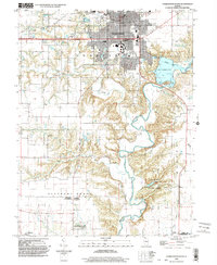
 1998 Mattoon East2002 Print · USGSThe eastern edge of Mattoon and the agricultural heart of Coles County are shown here at the turn of the millennium. Researchers can locate the small settlements of Lerna and Loxa or trace the winding paths of Kickapoo Creek and Indian Creek.
 - 1998 Map of Westfield West, 2003 Print
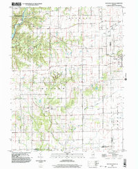 1998 Westfield West2003 Print · USGSThe prairie and timber lands of east-central Illinois are shown here in the late twentieth century as the Embarras River bypasses Charleston. Researchers can trace rural cemetery sites and old industrial markers like the Mill near Westfield or the Gas Fields Creek drainage.
 - 1998 Map of Charleston South, 2003 Print
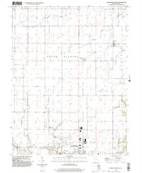
 1998 Charleston South2003 Print · USGSSouth of the city at the turn of the millennium, this area shows the historic sites and river valleys of Coles and Cumberland Counties. Genealogists can trace family connections in Campbell (Farmington) or locate the Lincoln Log Cabin State Historic Site.
 - 1998 Map of Charleston North, 2003 Print
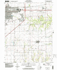
 1998 Charleston North2003 Print · USGSThe northern outskirts of Charleston and the surrounding prairie townships are captured here in the late 1990s. Genealogists and local historians can trace family locations near North Union Ch, Mound Cem, and the small agricultural settlements of Fairgrange and Bushton.
End of results
Showing maps 1-4 of 4
Top cities near Charleston
- Mattoon historical maps
- Casey historical maps
- Arcola historical maps
- Greenup historical maps
- Toledo historical maps
- Oakland historical maps
See more
Frequently asked questions
- What are the different types of historical maps available for Charleston?
- What is the oldest map of Charleston?
- Where can I purchase historical maps of Charleston for my home or office?
- Where can I download high-res historical maps of Charleston?
- Are there historical topographic maps available for Charleston?
- Is there historical aerial imagery available for Charleston?
- Where are historical maps of Charleston sourced from?