1980s Maps of Charleston, Illinois
Explore 6 historic maps of Charleston from the 1980s. These maps offer a rare glimpse into what life looked like during the 1980s — showing old roads, neighborhoods, homes, and landmarks that have changed or disappeared over time.
Whether you're researching your family's past, planning a metal detecting trip, or studying how Charleston's landscape evolved across the 1980s, these high-resolution maps are a powerful tool for exploring the history of this region.
- Focus on a specific era: All maps on this page are from the 1980s, giving you a focused view of this time period.
- See what’s changed: Compare century-old streets, trails, and buildings to today's modern landscape using overlays and satellite layers.
- Research with precision: Use these maps for genealogy, historical research, land use analysis, or educational projects.
- View, download, or print: Maps are fully viewable online in high resolution, and can be downloaded or printed for your own records.
Start exploring Charleston's history through authentic maps from the 1980s. This is your window into the past.
Charleston, IL maps
(6)- 1982 Map of Charleston North, 1983 Print
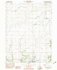 1982 Charleston North1983 Print · USGSColes County at the start of the 1980s shows a landscape of productive prairie farmland and small rail-stop settlements. Genealogists and local historians can locate early burial grounds like Winkleblack Cem and family-named landmarks such as Cassell Creek.
 - 1984 Map of Charleston South, 1985 Print
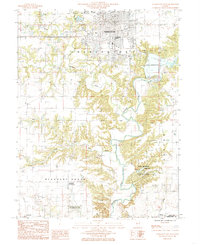 1984 Charleston South1985 Print · USGSColes County at the mid-eighties shows the transition from the university city of Charleston to the timbered bluffs of the Embarras River. Researchers can locate family landmarks at the Lincoln Log Cabin State Historic Site or near the waters of Lake Charleston.
 - 1984 Map of Westfield West, 1985 Print
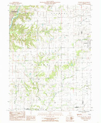 1984 Westfield West1985 Print · USGSThe rural borderlands of Coles and Clark counties come to life in the early 1980s, showing a landscape defined by prairie farmsteads and river bluffs. Researchers can trace family history through numerous CEM sites and the remote reaches of Embarras River and Hurricane Creek.
 - 1984 Map of Mattoon East, 1985 Print
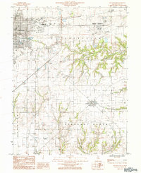 1984 Mattoon East1985 Print · USGSColes County in the mid-1980s shows the eastern expansion of Mattoon into the surrounding prairies and creek valleys. Genealogists and local historians can trace the rail networks of the Illinois Central Gulf through small communities like Lerna, Loxa, and Trilla.
 - 1985 Map of Decatur
 1985 Decatur1985 Print · USGSCentral Illinois farming and rail hubs thrive in the mid-1980s as Decatur anchors a sprawling network of track and timber. Trace the paths of the Sangamon River and the Illinois Central Gulf RR through old towns like Cerro Gordo and Bement.2 unique versions available
 - 1986 Map of Effingham
 1986 Effingham1986 Print · USGSCentral Illinois during the mid-eighties was a hub of rail travel and water recreation centered on the new reservoirs. Genealogists and historians can trace the rural landscape between Mattoon and Effingham, locating landmarks like St Paul Ch and Eagle Creek State Park.2 unique versions available
End of results
Showing maps 1-6 of 6
Top cities near Charleston
- Mattoon historical maps
- Casey historical maps
- Arcola historical maps
- Greenup historical maps
- Toledo historical maps
- Oakland historical maps
See more
Frequently asked questions
- What are the different types of historical maps available for Charleston?
- What is the oldest map of Charleston?
- Where can I purchase historical maps of Charleston for my home or office?
- Where can I download high-res historical maps of Charleston?
- Are there historical topographic maps available for Charleston?
- Is there historical aerial imagery available for Charleston?
- Where are historical maps of Charleston sourced from?