1940s Maps of Crawford County, Illinois
Explore 2 historic maps of Crawford County from the 1940s. These maps offer a rare glimpse into what life looked like during the 1940s — showing old roads, neighborhoods, homes, and landmarks that have changed or disappeared over time.
Whether you're researching your family's past, planning a metal detecting trip, or studying how Crawford County's landscape evolved across the 1940s, these high-resolution maps are a powerful tool for exploring the history of this region.
- Focus on a specific era: All maps on this page are from the 1940s, giving you a focused view of this time period.
- See what’s changed: Compare century-old streets, trails, and buildings to today's modern landscape using overlays and satellite layers.
- Research with precision: Use these maps for genealogy, historical research, land use analysis, or educational projects.
- View, download, or print: Maps are fully viewable online in high resolution, and can be downloaded or printed for your own records.
Start exploring Crawford County's history through authentic maps from the 1940s. This is your window into the past.
Crawford County, IL maps
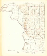
(2)- 1942 Map of Birds, 1958 Print
 1942 Birds1958 Print · USGSThe Wabash River valley comes to life in this mid-century survey of the Illinois-Indiana borderlands. Genealogists can locate family lands near Oil Grove or trace ancestors through rural landmarks like Buncombe School and Brightlight Ferry.
 - 1943 Map of Merom
 1943 Merom1943 Print · USGSThe Wabash River bluffs of Sullivan County are documented here during the early years of the war. Researchers can trace family history through several local landmarks like Merom Institute, the Old French Cem, and the river community of Riverton.2 unique versions available
End of results
Showing maps 1-2 of 2
Top cities of Crawford County
- Robinson historical maps
- Oblong historical maps
- Palestine historical maps
- Hutsonville historical maps
- Flat Rock historical maps
- Stoy historical maps
Frequently asked questions
- What are the different types of historical maps available for Crawford County?
- What is the oldest map of Crawford County?
- Where can I purchase historical maps of Crawford County for my home or office?
- Where can I download high-res historical maps of Crawford County?
- Are there historical topographic maps available for Crawford County?
- Is there historical aerial imagery available for Crawford County?
- Where are historical maps of Crawford County sourced from?