1970s Maps of DeKalb County, Illinois
Explore 8 historic maps of DeKalb County from the 1970s. These maps offer a rare glimpse into what life looked like during the 1970s — showing old roads, neighborhoods, homes, and landmarks that have changed or disappeared over time.
Whether you're researching your family's past, planning a metal detecting trip, or studying how DeKalb County's landscape evolved across the 1970s, these high-resolution maps are a powerful tool for exploring the history of this region.
- Focus on a specific era: All maps on this page are from the 1970s, giving you a focused view of this time period.
- See what’s changed: Compare century-old streets, trails, and buildings to today's modern landscape using overlays and satellite layers.
- Research with precision: Use these maps for genealogy, historical research, land use analysis, or educational projects.
- View, download, or print: Maps are fully viewable online in high resolution, and can be downloaded or printed for your own records.
Start exploring DeKalb County's history through authentic maps from the 1970s. This is your window into the past.
DeKalb County, IL maps
(8)- 1971 Map of Lee, 1973 Print
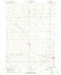 1971 Lee1973 Print · USGSNorthern Illinois farm country in the early seventies is documented here as the Burlington Northern railroad connected rural hubs. Genealogists can locate family sites at Union Cem, Calvary Ch, or follow the Old Railroad Grade.
 - 1971 Map of Paw Paw, 1973 Print
 1971 Paw Paw1973 Print · USGSNorthern Illinois farm country near the intersection of Lee, DeKalb, and La Salle Counties is shown here in the early 1970s. Trace family history at the Wyoming Cemetery, locate the Rogers Brothers Landing Strip, and follow the Chicago Burlington and Northern Railroad through Rollo and Radley.
 - 1971 Map of Waterman, 1973 Print
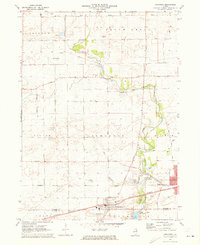
 1971 Waterman1973 Print · USGSDeKalb County farmland is shown in transition during the early seventies, centered on the rail junctions and prairie townships of Waterman and Shabbona. Genealogists and local historians can locate the Chief Shabbona Grave, Afton Center Cem, and the small siding at McGirr.
 - 1971 Map of Creston, 1973 Print
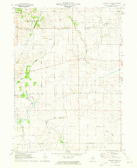
 1971 Creston1973 Print · USGSCreston and its neighboring townships are captured in the early seventies during a period of established agricultural growth and institutional expansion. Trace local family history and property lines near Woodlawn Cem, Kishwaukee College, or along the Chicago and North Western rail line.2 unique versions available
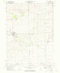
 - 1971 Map of De Kalb, 1973 Print
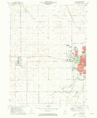 1971 De Kalb1973 Print · USGSDe Kalb and the surrounding Illinois prairie are captured here during a period of mid-century academic and civic growth. Researchers can trace the development of Northern Illinois University or locate family roots at Malta Cem and the Open Bible Ch.2 unique versions available
 - 1971 Map of Shabbona Grove, 1973 Print
 1971 Shabbona Grove1973 Print · USGSThe borderlands of DeKalb and La Salle counties are captured in the early 1970s as a landscape of productive fields and historic rural outposts. Genealogists can trace the Shabbona Grove area and identify isolated burying grounds like Johnson Grove Cem and Victor Cem.2 unique versions available
 - 1971 Map of Plano, 1973 Print
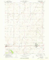
 1971 Plano1973 Print · USGSKendall County's river-and-rail corridor is captured here in the early seventies, showing the growth of Plano and Sandwich. Local historians can trace family landmarks and rural infrastructure, from Plano Cem to the Burlington Northern rail line.
 - 1971 Map of Somonauk, 1973 Print
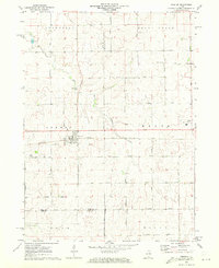
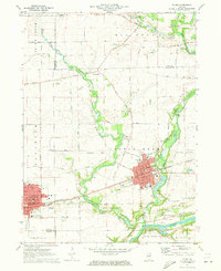
 1971 Somonauk1973 Print · USGSDe Kalb and La Salle Counties are captured in the early seventies, showing the transition between traditional farming and modern lakefront development. Trace family heritage through rural landmarks like Somonauk Church, Oak Ridge Cemetery, and the Burlington Northern rail line.
End of results
Showing maps 1-8 of 8
Top cities of DeKalb County
Frequently asked questions
- What are the different types of historical maps available for DeKalb County?
- What is the oldest map of DeKalb County?
- Where can I purchase historical maps of DeKalb County for my home or office?
- Where can I download high-res historical maps of DeKalb County?
- Are there historical topographic maps available for DeKalb County?
- Is there historical aerial imagery available for DeKalb County?
- Where are historical maps of DeKalb County sourced from?