1990s Maps of Hume, Illinois
Explore 2 historic maps of Hume from the 1990s. These maps offer a rare glimpse into what life looked like during the 1990s — showing old roads, neighborhoods, homes, and landmarks that have changed or disappeared over time.
Whether you're researching your family's past, planning a metal detecting trip, or studying how Hume's landscape evolved across the 1990s, these high-resolution maps are a powerful tool for exploring the history of this region.
- Focus on a specific era: All maps on this page are from the 1990s, giving you a focused view of this time period.
- See what’s changed: Compare century-old streets, trails, and buildings to today's modern landscape using overlays and satellite layers.
- Research with precision: Use these maps for genealogy, historical research, land use analysis, or educational projects.
- View, download, or print: Maps are fully viewable online in high resolution, and can be downloaded or printed for your own records.
Start exploring Hume's history through authentic maps from the 1990s. This is your window into the past.
Hume, IL maps
(2)- 1998 Map of Newman, 2002 Print
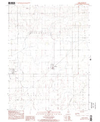
 1998 Newman2002 Print · USGSDouglas and Edgar counties come into focus during the late 1990s, centered on the residential grid of Newman. Genealogists and local historians can locate Pleasant Ridge Cem, trace the waters of Brushy Fork, and find rural landmarks like Palermo Ch.
 - 1998 Map of Hume, 2002 Print
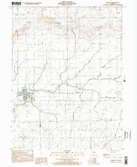
 1998 Hume2002 Print · USGSThis Edgar County landscape shows the rural layout of the region during the late nineties, centered on the villages of Hume and Metcalf. Genealogists and local historians can trace family locations near the Young America Cem, Shiloh Sch, and the winding Brushy Fork.
End of results
Showing maps 1-2 of 2
Top cities near Hume
- Paris historical maps
- Georgetown historical maps
- Chrisman historical maps
- Sidney historical maps
- Oakland historical maps
- Newman historical maps
See more
Frequently asked questions
- What are the different types of historical maps available for Hume?
- What is the oldest map of Hume?
- Where can I purchase historical maps of Hume for my home or office?
- Where can I download high-res historical maps of Hume?
- Are there historical topographic maps available for Hume?
- Is there historical aerial imagery available for Hume?
- Where are historical maps of Hume sourced from?