1900s (20th Century) Maps of Pine Grove, Illinois
Explore 8 historic maps of Pine Grove from the 1900s (20th Century). These maps offer a rare glimpse into what life looked like during the 1900s — showing old roads, neighborhoods, homes, and landmarks that have changed or disappeared over time.
Whether you're researching your family's past, planning a metal detecting trip, or studying how Pine Grove's landscape evolved across the 1900s, these high-resolution maps are a powerful tool for exploring the history of this region.
- Focus on a specific era: All maps on this page are from the 1900s, giving you a focused view of this time period.
- See what’s changed: Compare century-old streets, trails, and buildings to today's modern landscape using overlays and satellite layers.
- Research with precision: Use these maps for genealogy, historical research, land use analysis, or educational projects.
- View, download, or print: Maps are fully viewable online in high resolution, and can be downloaded or printed for your own records.
Start exploring Pine Grove's history through authentic maps from the 1900s. This is your window into the past.
Pine Grove, IL maps
(8)- 1918 Map of Morris
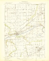 1918 Morris1918 Print · USGSGrundy County at the end of the Great War is a landscape defined by the Illinois River and a bustling coal industry. Researchers can trace historic school districts like Jugtown School, the path of the Michigan and Illinois Canal, and early mining settlements such as Carbon Hill and Eileen.3 unique versions available
 - 1953 Map of Morris, 1955 Print
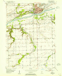 1953 Morris1955 Print · USGSMorris and the surrounding Grundy County river lands were thriving in the early fifties as industry and transit intersected along the Illinois River. Genealogists and local historians can trace rural school locations like Stein Sch and Haymond Sch, or locate family sites near Zion Ch and the Evergreen Cem.3 unique versions available
 - 1954 Map of Morris, 1960 Print
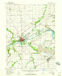 1954 Morris1960 Print · USGSGrundy County in the mid-fifties is a landscape of industrial transition, where coal mining and river navigation drive local growth. Researchers can trace the extensive Strip Mine works around Coal City or locate family roots at Evergreen Cem and Sulphur Springs Sch.2 unique versions available
 - 1958 Map of Aurora, 1969 Print
 1958 Aurora1969 Print · USGSNorthern Illinois in the late fifties shows a landscape of powerful river industry and expanding transport corridors. Genealogists and historians can trace the development of Aurora and Joliet or locate sites like the Elwood Ordnance Plant and Starved Rock.3 unique versions available
 - 1961 Map of Aurora
 1961 Aurora1961 Print · USGSNorthern Illinois at the height of the post-war era reveals a landscape of massive industrial works and thriving river towns. Genealogists and historians can trace the paths of the Lincoln Highway or locate long-standing landmarks like the Green River Ordnance Plant and Starved Rock State Park.
 - 1985 Map of Ottawa
 1985 Ottawa1985 Print · USGSThe Illinois River valley in the mid-1980s shows a landscape balancing river commerce with sprawling energy and mining operations. Researchers can trace the layout of mining towns like Coal City or find family landmarks such as Oakwood Memorial Cem and Smiths Mound.
 - 1991 Map of Ottawa
 1991 Ottawa1991 Print · USGSNorth-central Illinois in the early nineties remains a vital corridor of river commerce and heavy rail. Genealogists and historians can trace the legacy of industrial mining near Morris or explore the river-bluff geography of Starved Rock State Park and Buffalo Rock.
 - 1993 Map of Morris, 1994 Print
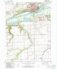 1993 Morris1994 Print · USGSThe Illinois River corridor near Morris thrives as a hub of canal history and rail transport in the early nineties. Genealogists and local historians can locate Evergreen Cem, trace the CSX RR line, and find vanished rural landmarks like Pavilionville.
End of results
Showing maps 1-8 of 8
Top cities near Pine Grove
- Joliet historical maps
- Channahon historical maps
- Shorewood historical maps
- Morris historical maps
- Minooka historical maps
- Aux Sable historical maps
See more
Frequently asked questions
- What are the different types of historical maps available for Pine Grove?
- What is the oldest map of Pine Grove?
- Where can I purchase historical maps of Pine Grove for my home or office?
- Where can I download high-res historical maps of Pine Grove?
- Are there historical topographic maps available for Pine Grove?
- Is there historical aerial imagery available for Pine Grove?
- Where are historical maps of Pine Grove sourced from?