1970s Maps of Hancock County, Illinois
Explore 9 historic maps of Hancock County from the 1970s. These maps offer a rare glimpse into what life looked like during the 1970s — showing old roads, neighborhoods, homes, and landmarks that have changed or disappeared over time.
Whether you're researching your family's past, planning a metal detecting trip, or studying how Hancock County's landscape evolved across the 1970s, these high-resolution maps are a powerful tool for exploring the history of this region.
- Focus on a specific era: All maps on this page are from the 1970s, giving you a focused view of this time period.
- See what’s changed: Compare century-old streets, trails, and buildings to today's modern landscape using overlays and satellite layers.
- Research with precision: Use these maps for genealogy, historical research, land use analysis, or educational projects.
- View, download, or print: Maps are fully viewable online in high resolution, and can be downloaded or printed for your own records.
Start exploring Hancock County's history through authentic maps from the 1970s. This is your window into the past.
Hancock County, IL maps
(9)- 1974 Map of Bentley, 1978 Print
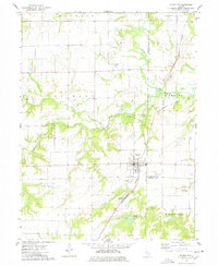
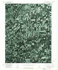
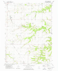 1974 Bentley1978 Print · USGSHancock County farmland is seen here in the mid-1970s as a landscape of rural townships and family-run homesteads. Genealogists and local historians can locate early burial sites like Harmony Cem and Browning Cem or trace the NORFOLK AND WESTERN rail line.
 - 1974 Map of West Point, 1978 Print
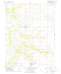 1974 West Point1978 Print · USGSThe quiet farming townships of western Illinois are captured here in the mid-1970s, centered on the villages of Basco and West Point. Genealogists can locate several local burial grounds like Bethel Cem and trace the path of the Old Railroad Grade.
 - 1974 Map of Fountain Green, 1978 Print
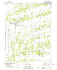
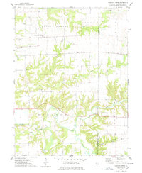 1974 Fountain Green1978 Print · USGSHancock and McDonough Counties are shown in the mid-1970s, a landscape where rural township life centers on small crossroads and winding creek systems. Genealogists can locate several family burial grounds like Lincoln Cem and Yetter Cem, alongside landmarks like Majorville Ch.
 - 1974 Map of Stronghurst, 1978 Print
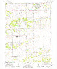 1974 Stronghurst1978 Print · USGSWestern Illinois farmland and the villages along the Santa Fe and Topeka Atchison railroad appear in this mid-seventies survey. Researchers can locate remote rural sites like the Old Bedford Ch, Smith Landing Strip, and Peasley Cem.
 - 1974 Map of La Harpe, 1978 Print
 1974 La Harpe1978 Print · USGSLa Harpe and Blandinsville sit at the heart of this mid-1970s Illinois survey, which details the agricultural landscape along the Hancock and McDonough county line. Genealogists and rail historians can trace the Toledo Peoria and Western line or locate rural sites like Chapel Cem and the Landing Field.
 - 1974 Map of Carthage East, 1978 Print
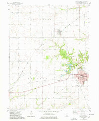
 1974 Carthage East1978 Print · USGSHancock County in the mid-1970s reveals a productive Illinois landscape where the eastern outskirts of Carthage meet the winding La Moine River. Genealogists and local researchers can trace historic burial sites like Old Brick Cem and landmarks such as the Robert Morris Jr College campus.
 - 1974 Map of Plymouth, 1978 Print
 1974 Plymouth1978 Print · USGSHancock and McDonough counties meet here in the mid-1970s, where rural industry and rail lines converge. Genealogists and historians can trace the Colmar - Plymouth Oil Field and family sites like Trimble Cem or Irwin Cem.
 - 1974 Map of Carthage West, 1978 Print
 1974 Carthage West1978 Print · USGSHancock County in the mid-1970s exhibits a landscape of organized prairie agriculture and bustling rail-junction towns. Genealogists and historians can trace the foundations of Carthage through its local institutions like Robert Morris Jr College and several burial grounds, including Moss Ridge Cem.
 - 1975 Map of Augusta NW, 1976 Print
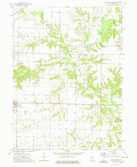
 1975 Augusta NW1976 Print · USGSIllinois farmland and rural settlements are captured in high-detail aerial photography during the mid-seventies. Researchers can pinpoint specific farmsteads and the historic town layouts of Augusta and La Prairie as they existed fifty years ago.
End of results
Showing maps 1-9 of 9
Top cities of Hancock County
- Hamilton historical maps
- Carthage historical maps
- Warsaw historical maps
- La Harpe historical maps
- Nauvoo historical maps
- Chili historical maps
See more
Frequently asked questions
- What are the different types of historical maps available for Hancock County?
- What is the oldest map of Hancock County?
- Where can I purchase historical maps of Hancock County for my home or office?
- Where can I download high-res historical maps of Hancock County?
- Are there historical topographic maps available for Hancock County?
- Is there historical aerial imagery available for Hancock County?
- Where are historical maps of Hancock County sourced from?