1930s Maps of Hancock County, Illinois
Explore 6 historic maps of Hancock County from the 1930s. These maps offer a rare glimpse into what life looked like during the 1930s — showing old roads, neighborhoods, homes, and landmarks that have changed or disappeared over time.
Whether you're researching your family's past, planning a metal detecting trip, or studying how Hancock County's landscape evolved across the 1930s, these high-resolution maps are a powerful tool for exploring the history of this region.
- Focus on a specific era: All maps on this page are from the 1930s, giving you a focused view of this time period.
- See what’s changed: Compare century-old streets, trails, and buildings to today's modern landscape using overlays and satellite layers.
- Research with precision: Use these maps for genealogy, historical research, land use analysis, or educational projects.
- View, download, or print: Maps are fully viewable online in high resolution, and can be downloaded or printed for your own records.
Start exploring Hancock County's history through authentic maps from the 1930s. This is your window into the past.
Hancock County, IL maps
(6)- 1932 Map of Lomax, 1957 Print
 1932 Lomax1957 Print · USGSWestern Illinois river towns and railroad junctions thrive during the early 1930s as the river remains a central artery for commerce and life. Genealogists can trace family footprints across dozens of rural landmarks, including Dallas City, Gittings Mound, and the uniquely named Froggie Sch.
 - 1933 Map of Carthage, 1965 Print
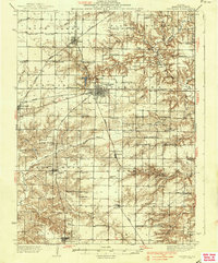
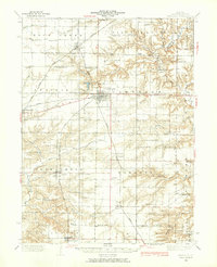 1933 Carthage1965 Print · USGSHancock County was a thriving network of rail-side towns and rural schools in the early 1930s. Researchers can trace family ties at the County Farm or locate vanished landmarks like Young America School and Middle Creek Church.
 - 1936 Map of Keokuk
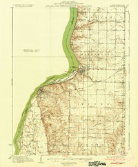 1936 Keokuk1936 Print · USGSHancock County and the Mississippi River transition into a new era of hydroelectric power and rail transit in the 1930s. Genealogists can locate dozens of country schools and churches, from Froggy Sch and Sylvanvale Sch to Sanobia Ch.3 unique versions available
 - 1936 Map of Fort Madison
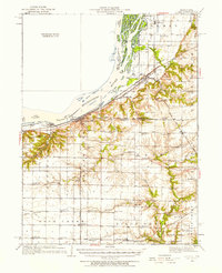
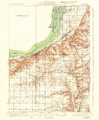
 1936 Fort Madison1936 Print · USGSThe Illinois shore of the Mississippi River is captured here in the mid-1930s, featuring the historic street grid of Nauvoo. Genealogists and local historians can trace a dense network of rural landmarks, including Jackson Cem and numerous country schoolhouses like Maple Grove Sch and Elliott Sch.3 unique versions available
 - 1937 Map of Carthage
 1937 Carthage1937 Print · USGSHancock County in the 1930s was a landscape defined by its rail-connected villages and a dense network of country schools. Genealogists can trace family footprints across dozens of local landmarks like Moss Ridge Cem, Young America Sch, and the County Farm.2 unique versions available
 - 1937 Map of Lomax
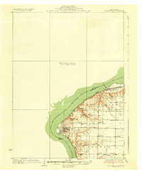
 1937 Lomax1937 Print · USGSThe riverfront and rail corridors of Henderson and Hancock Counties come alive in the late 1930s, documenting a time of active country schools and river commerce. Genealogists can locate family landmarks like Gittings Cem, Enterprise Ch, and distinctively named sites like Shake Rag Sch.2 unique versions available
End of results
Showing maps 1-6 of 6
Top cities of Hancock County
- Hamilton historical maps
- Carthage historical maps
- Warsaw historical maps
- La Harpe historical maps
- Nauvoo historical maps
- Chili historical maps
See more
Frequently asked questions
- What are the different types of historical maps available for Hancock County?
- What is the oldest map of Hancock County?
- Where can I purchase historical maps of Hancock County for my home or office?
- Where can I download high-res historical maps of Hancock County?
- Are there historical topographic maps available for Hancock County?
- Is there historical aerial imagery available for Hancock County?
- Where are historical maps of Hancock County sourced from?