1940s Maps of Willow Hill, Illinois
Explore 4 historic maps of Willow Hill from the 1940s. These maps offer a rare glimpse into what life looked like during the 1940s — showing old roads, neighborhoods, homes, and landmarks that have changed or disappeared over time.
Whether you're researching your family's past, planning a metal detecting trip, or studying how Willow Hill's landscape evolved across the 1940s, these high-resolution maps are a powerful tool for exploring the history of this region.
- Focus on a specific era: All maps on this page are from the 1940s, giving you a focused view of this time period.
- See what’s changed: Compare century-old streets, trails, and buildings to today's modern landscape using overlays and satellite layers.
- Research with precision: Use these maps for genealogy, historical research, land use analysis, or educational projects.
- View, download, or print: Maps are fully viewable online in high resolution, and can be downloaded or printed for your own records.
Start exploring Willow Hill's history through authentic maps from the 1940s. This is your window into the past.
Willow Hill, IL maps
(4)- 1940 Map of Greenup, 1958 Print
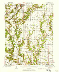 1940 Greenup1958 Print · USGSCumberland and Jasper Counties are shown in detail as they appeared just before the war, dominated by the winding valley of the Embarrass River. Genealogists can trace dozens of country schools and churches, including Scotch Chapel Sch, Hazel Dell, and Washington Cem.2 unique versions available
 - 1941 Map of Newton, 1972 Print
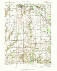 1941 Newton1972 Print · USGSJasper and Richland counties appear here during the early 1940s, showing a landscape of river-valley farms and small rail towns. Genealogists can trace family footprints through dozens of rural landmarks like Onion Prairie Sch, Bethel Cem, and Willow Hill.
 - 1943 Map of Greenup
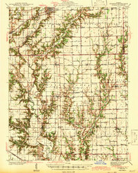 1943 Greenup1943 Print · USGSCumberland and Jasper counties are captured here in the early 1940s, highlighting a landscape defined by the Embarrass River and the historic National Road. Researchers can locate dozens of rural schools and family landmarks, from Hunt City to the Washington Cem and Wade Sch.2 unique versions available
 - 1943 Map of Newton
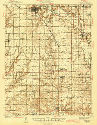 1943 Newton1943 Print · USGSJasper and Richland counties are captured here in the early 1940s, showing a landscape defined by the Embarrass River and the Illinois Central railroad. Genealogists can locate dozens of country schools and churches, from Brush College Sch to Shiloh Ch.2 unique versions available
End of results
Showing maps 1-4 of 4
Top cities near Willow Hill
- Newton historical maps
- Oblong historical maps
- Hunt City historical maps
- Orange historical maps
- Jewett historical maps
- Hidalgo historical maps
See more
Frequently asked questions
- What are the different types of historical maps available for Willow Hill?
- What is the oldest map of Willow Hill?
- Where can I purchase historical maps of Willow Hill for my home or office?
- Where can I download high-res historical maps of Willow Hill?
- Are there historical topographic maps available for Willow Hill?
- Is there historical aerial imagery available for Willow Hill?
- Where are historical maps of Willow Hill sourced from?