1980s Maps of Willow Hill, Illinois
Explore 4 historic maps of Willow Hill from the 1980s. These maps offer a rare glimpse into what life looked like during the 1980s — showing old roads, neighborhoods, homes, and landmarks that have changed or disappeared over time.
Whether you're researching your family's past, planning a metal detecting trip, or studying how Willow Hill's landscape evolved across the 1980s, these high-resolution maps are a powerful tool for exploring the history of this region.
- Focus on a specific era: All maps on this page are from the 1980s, giving you a focused view of this time period.
- See what’s changed: Compare century-old streets, trails, and buildings to today's modern landscape using overlays and satellite layers.
- Research with precision: Use these maps for genealogy, historical research, land use analysis, or educational projects.
- View, download, or print: Maps are fully viewable online in high resolution, and can be downloaded or printed for your own records.
Start exploring Willow Hill's history through authentic maps from the 1980s. This is your window into the past.
Willow Hill, IL maps
(4)- 1985 Map of Ste Marie
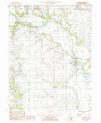 1985 Ste Marie1985 Print · USGSJasper County in the mid-1980s reveals a quiet landscape of river bends and rural settlements along the Embarras River. Researchers can trace the layout of the Ste Marie community, locate the local St Marie Ch, or explore the terrain around the ancient Indian Mound.
 - 1985 Map of Yale
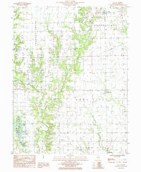 1985 Yale1985 Print · USGSJasper County in the mid-1980s reveals a landscape of active oil production and rural villages connected by the winding Crooked Creek. Trace local history through the streets of Yale, the layout of Hunt City, and the recreation areas at Sam Parr State Park.
 - 1986 Map of Olney
 1986 Olney1986 Print · USGSSouth-central Illinois in the mid-eighties shows a landscape of small agricultural towns linked by historic rail lines and prairie preserves. Trace family roots and vanished rail stops near Kinmundy, the Prairie Chicken Sanctuary, and Salem.2 unique versions available
 - 1986 Map of Effingham
 1986 Effingham1986 Print · USGSCentral Illinois during the mid-eighties was a hub of rail travel and water recreation centered on the new reservoirs. Genealogists and historians can trace the rural landscape between Mattoon and Effingham, locating landmarks like St Paul Ch and Eagle Creek State Park.2 unique versions available
End of results
Showing maps 1-4 of 4
Top cities near Willow Hill
- Newton historical maps
- Oblong historical maps
- Hunt City historical maps
- Orange historical maps
- Jewett historical maps
- Hidalgo historical maps
See more
Frequently asked questions
- What are the different types of historical maps available for Willow Hill?
- What is the oldest map of Willow Hill?
- Where can I purchase historical maps of Willow Hill for my home or office?
- Where can I download high-res historical maps of Willow Hill?
- Are there historical topographic maps available for Willow Hill?
- Is there historical aerial imagery available for Willow Hill?
- Where are historical maps of Willow Hill sourced from?