1940s Maps of Jefferson County, Illinois
Explore 7 historic maps of Jefferson County from the 1940s. These maps offer a rare glimpse into what life looked like during the 1940s — showing old roads, neighborhoods, homes, and landmarks that have changed or disappeared over time.
Whether you're researching your family's past, planning a metal detecting trip, or studying how Jefferson County's landscape evolved across the 1940s, these high-resolution maps are a powerful tool for exploring the history of this region.
- Focus on a specific era: All maps on this page are from the 1940s, giving you a focused view of this time period.
- See what’s changed: Compare century-old streets, trails, and buildings to today's modern landscape using overlays and satellite layers.
- Research with precision: Use these maps for genealogy, historical research, land use analysis, or educational projects.
- View, download, or print: Maps are fully viewable online in high resolution, and can be downloaded or printed for your own records.
Start exploring Jefferson County's history through authentic maps from the 1940s. This is your window into the past.
Jefferson County, IL maps
(7)- 1940 Map of Mount Vernon
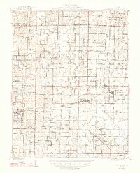
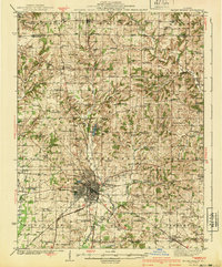 1940 Mount Vernon1940 Print · USGSMount Vernon and the surrounding Jefferson County countryside are captured here during the late Depression years. Researchers can trace rural family life through dozens of named country schools and churches like George College Sch, Old Shiloh Ch, and Atkinson Cem.2 unique versions available
 - 1942 Map of McLeansboro, 1961 Print
 1942 McLeansboro1961 Print · USGSHamilton County in the early 1940s was a landscape of tightly-knit farming communities and small rail stops. Genealogists can trace family roots through a remarkable number of local landmarks like Piopolis, Seminary Sch, and Union Hill Cem.2 unique versions available
 - 1943 Map of Ina
 1943 Ina1943 Print · USGSSouthern Illinois during the mid-forties reveals a complex grid of rural schools, coal-town rail spurs, and early collegiate outposts. Genealogists can trace family roots through dozens of local landmarks like Williams Chapel, Mason Cem, and the vanished desks of Hungry Hill Sch.2 unique versions available
 - 1943 Map of Ashley, 1967 Print
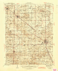
 1943 Ashley1967 Print · USGSSouthern Illinois during the early 1940s is captured here as a thriving rail and agricultural hub. Genealogists can locate specific family-linked landmarks like the Blissville Polling House, Conta Colliery, and the Odd Fellows Cem.
 - 1945 Map of McLeansboro
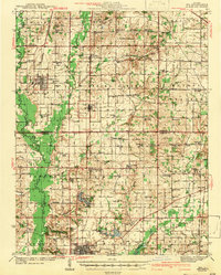
 1945 McLeansboro1945 Print · USGSIn the mid-1940s, this portion of Southern Illinois was a landscape of steam-era rail junctions and tight-knit rural school districts. Genealogists can trace family roots through scores of rural landmarks, from Knight Prairie and Piopolis to the Sulphur Springs Sch.2 unique versions available
 - 1946 Map of Ashley
 1946 Ashley1946 Print · USGSSouthern Illinois at the end of the war was a landscape of concentrated rail corridors and rural school districts. Genealogists can trace family roots through dozens of local landmarks like St Michael Cem, Oniontown, and the Blissville Polling House.
 - 1947 Map of Wayne City
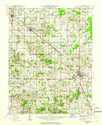
 1947 Wayne City1947 Print · USGSSouthern Illinois in the mid-1940s is captured here at a time when small rural schools and country churches still defined the local geography. Researchers can trace the rail-centered growth of Wayne City and Bluford or locate family sites like Garrison Temple, Thomason Cem, and Berry Sch.3 unique versions available
End of results
Showing maps 1-7 of 7
Top cities of Jefferson County
- Mount Vernon historical maps
- Spring Garden historical maps
- Ina historical maps
- Bluford historical maps
- Woodlawn historical maps
- Dix historical maps
See more
Frequently asked questions
- What are the different types of historical maps available for Jefferson County?
- What is the oldest map of Jefferson County?
- Where can I purchase historical maps of Jefferson County for my home or office?
- Where can I download high-res historical maps of Jefferson County?
- Are there historical topographic maps available for Jefferson County?
- Is there historical aerial imagery available for Jefferson County?
- Where are historical maps of Jefferson County sourced from?