1970s Maps of Jefferson County, Illinois
Explore 13 historic maps of Jefferson County from the 1970s. These maps offer a rare glimpse into what life looked like during the 1970s — showing old roads, neighborhoods, homes, and landmarks that have changed or disappeared over time.
Whether you're researching your family's past, planning a metal detecting trip, or studying how Jefferson County's landscape evolved across the 1970s, these high-resolution maps are a powerful tool for exploring the history of this region.
- Focus on a specific era: All maps on this page are from the 1970s, giving you a focused view of this time period.
- See what’s changed: Compare century-old streets, trails, and buildings to today's modern landscape using overlays and satellite layers.
- Research with precision: Use these maps for genealogy, historical research, land use analysis, or educational projects.
- View, download, or print: Maps are fully viewable online in high resolution, and can be downloaded or printed for your own records.
Start exploring Jefferson County's history through authentic maps from the 1970s. This is your window into the past.
Jefferson County, IL maps
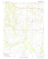
(13)- 1973 Map of Shields, 1975 Print
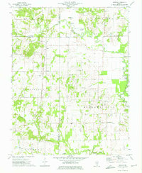 1973 Shields1975 Print · USGSWayne and Jefferson counties come alive in the early seventies, showing a landscape defined by the Orchardville Oil Field and rural river crossings. Trace family roots at the McConaughhay Cem, locate the old Ten Foot Oak Ch, or follow the Skillet Fork to Greathouse Ford.
 - 1973 Map of Bluford, 1975 Print
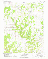
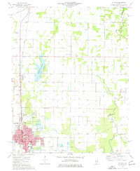
 1973 Bluford1975 Print · USGSJefferson and Wayne Counties appear here in the early 1970s as centers of rail transport and petroleum production. Researchers can trace family history through landmarks like Long Prairie Cem, Bluford Sch, and the Markham City Oil Field.2 unique versions available
 - 1974 Map of Dahlgren, 1977 Print
 1974 Dahlgren1977 Print · USGSSouthern Illinois prairie life in the mid-1970s is centered on the rail junctions of Dahlgren and Belle Rive. Genealogists can trace family names through dozens of rural sites, including St Johns Cem, Sugar Camp Ch, and Little Egypt Youth Camp.
 - 1974 Map of Spring Garden, 1977 Print
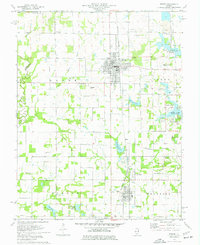
 1974 Spring Garden1977 Print · USGSJefferson County's rural and industrial character is preserved here in the mid-1970s, as traditional farmsteads share the land with emerging energy extraction. Genealogists can trace deep local roots through Spring Garden, Fitzgerrell Cem, and numerous country churches like New Hope Ch.
 - 1974 Map of Woodlawn, 1978 Print
 1974 Woodlawn1978 Print · USGSJefferson County in the mid-seventies shows a landscape defined by the BIG MUDDY RIVER and a dense network of country cemeteries. Genealogists can trace family roots through sites like Reynolds Cem, Slade Cem, and Black Cem, or locate the small settlement of Roaches.
 - 1974 Map of Walnut Hill, 1978 Print
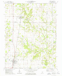
 1974 Walnut Hill1978 Print · USGSMarion and Jefferson counties are shown here in the mid-seventies, captured at the intersection of the regional railroad network and the local oil industry. Researchers can trace family sites at Gaston Cem, Grand Prairie Sch, and the small settlement of Cravat.
 - 1974 Map of Irvington, 1978 Print
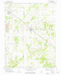
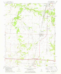 1974 Irvington1978 Print · USGSSouthern Illinois oil production and rail transport define this mid-1970s landscape near the Washington and Jefferson county line. Trace local history through the Irvington Oil Field, the Gulf Mobile and Ohio railroad, and family-named sites like Harres Cemetery.
 - 1974 Map of Ashley, 1978 Print
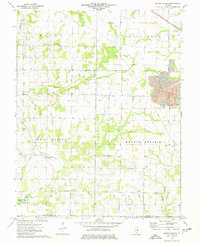
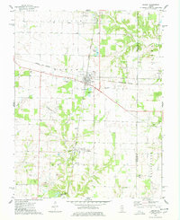 1974 Ashley1978 Print · USGSWashington and Jefferson counties are captured here in the mid-1970s, showcasing a landscape shaped by rail junctions and oil extraction. Genealogists can trace family roots through several rural sites including St Michael Cem, Liberty Cem, and Brick Cem.
 - 1975 Map of Ina, 1977 Print
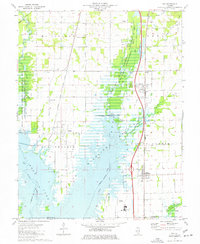 1975 Ina1977 Print · USGSSouthern Jefferson County is captured during the 1970s as the filling of Rend Lake reshapes the landscape around the Chicago and Eastern Illinois Railroad. Researchers can trace the heritage of Ina and Nason, find ancestral sites like Cub Prairie Cem, or locate the original Elk Prairie Ch.
 - 1975 Map of Du Quoin, 1977 Print
 1975 Du Quoin1977 Print · USGSMid-century Perry County is defined here by the intersection of industrial energy and small-town life. Researchers can trace the layout of Du Quoin during the 1970s, locating the Tamaroa South Oil Field, Browning Hospital, and several rural burial grounds.
 - 1975 Map of Waltonville, 1977 Print
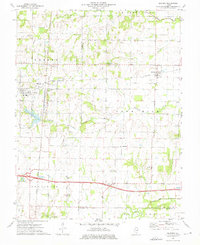
 1975 Waltonville1977 Print · USGSJefferson County was defined by its coal-and-rail economy in the 1970s, as industry expanded alongside the waters of Rend Lake. Trace family histories and local commerce through sites like Waltonville, the Orient No 3 Mine, and the St Barbara Cem.2 unique versions available
 - 1975 Map of Tamaroa, 1977 Print
 1975 Tamaroa1977 Print · USGSThe rail-and-river landscape of Perry and Washington Counties comes to life in this mid-seventies survey of the Illinois interior. Genealogists and historians can trace the Tamaroa Oil Field, the village of Tamaroa, and local landmarks like Antioch Cem and Curlee Cem.
 - 1975 Map of Sesser, 1977 Print
 1975 Sesser1977 Print · USGSDuring the mid-seventies, this area of Franklin County saw the industrial mining of the Old Ben No 21 Mine meet the growing waters of Rend Lake. Genealogists and local historians can trace rural cemeteries like Maple Hill Cem and Youngblood Cem alongside the BURLINGTON NORTHERN rail line.
End of results
Showing maps 1-13 of 13
Top cities of Jefferson County
- Mount Vernon historical maps
- Spring Garden historical maps
- Ina historical maps
- Bluford historical maps
- Woodlawn historical maps
- Dix historical maps
See more
Frequently asked questions
- What are the different types of historical maps available for Jefferson County?
- What is the oldest map of Jefferson County?
- Where can I purchase historical maps of Jefferson County for my home or office?
- Where can I download high-res historical maps of Jefferson County?
- Are there historical topographic maps available for Jefferson County?
- Is there historical aerial imagery available for Jefferson County?
- Where are historical maps of Jefferson County sourced from?