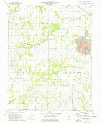
1974 Map of Spring Garden
USGS Topo · Published 1977About this map
The southern Jefferson County landscape is defined here by a transition from traditional rural agriculture to modern industrial extraction. Spring Garden and the smaller settlement of Townhall serve as the primary community anchors, while the southern reaches show the early 1970s development of the State Wildlife Management Area and the margins of Rend Lake. These civic centers are balanced by a heavy industrial presence, most notably the King Oil Field in the northwest and a significant Strip Mine operation in the east, complete with Tailings Ponds.
Find a feature on this map
39 named features on this map. Tap any name to fly to it.
Don’t see what you’re looking for? This feature index may not catch every label — zoom into the map to look around manually.
Map Details
Editions of this 1974 Spring Garden Map
This is the sole edition of this map. No revisions or reprints were ever made.
Other maps of this area

1933 · Mount Vernon
USGS Topo · 1:48,000

1939 · Ina
USGS Topo · 1:62,500

1940 · Mount Vernon
USGS Topo · 1:62,500

1942 · McLeansboro
USGS Topo · 1:62,500

1943 · Ina
USGS Topo · 1:62,500

1945 · McLeansboro
USGS Topo · 1:62,500

1947 · Wayne City
USGS Topo · 1:62,500

1958 · Belleville
USGS Topo · 1:250,000

1962 · Belleville
USGS Topo · 1:250,000

1964 · Opdyke
USGS Topo · 1:24,000