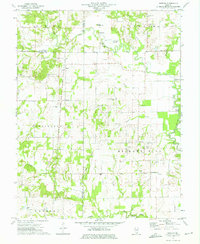
1973 Map of Shields
USGS Topo · Published 1975About this map
Orchardville Oil Field and numerous oil wells dominate the northern landscape of this Wayne County survey, illustrating the petroleum-based economy that shaped this corner of Illinois. The terrain is defined by the winding course of Skillet Fork, where historical crossings like Garrison Bridge and Greathouse Ford connected rural farming communities. Small settlements and local landmarks reveal a deeply rooted social structure, centered around places like Shields, Keenesville, and Stratton. Genealogists will find a wealth of family-named sites, including the McConaughhay Cem and Atteberry Cem, alongside rural congregations such as Ten Foot Oak Ch and Garrison Temple. The Illinois Central Gulf railroad cuts a straight north-south path through the center of the sheet, providing a stark contrast to the meandering waters of Paddy Creek and Possum Creek that drain the timbered bottomlands.
Find a feature on this map
50 named features on this map. Tap any name to fly to it.
Don’t see what you’re looking for? This feature index may not catch every label — zoom into the map to look around manually.
Map Details
Editions of this 1973 Shields Map
This is the sole edition of this map. No revisions or reprints were ever made.
Other maps of this area

1933 · Mount Vernon
USGS Topo · 1:48,000

1934 · Salem
USGS Topo · 1:62,500

1938 · Salem
USGS Topo · 1:62,500

1940 · Mount Vernon
USGS Topo · 1:62,500

1947 · Wayne City
USGS Topo · 1:62,500

1952 · Xenia
USGS Topo · 1:62,500

1958 · Belleville
USGS Topo · 1:250,000

1962 · Belleville
USGS Topo · 1:250,000

1964 · Opdyke
USGS Topo · 1:24,000

1965 · Iuka
USGS Topo · 1:24,000