1970s Maps of North Utica, Illinois
Explore 2 historic maps of North Utica from the 1970s. These maps offer a rare glimpse into what life looked like during the 1970s — showing old roads, neighborhoods, homes, and landmarks that have changed or disappeared over time.
Whether you're researching your family's past, planning a metal detecting trip, or studying how North Utica's landscape evolved across the 1970s, these high-resolution maps are a powerful tool for exploring the history of this region.
- Focus on a specific era: All maps on this page are from the 1970s, giving you a focused view of this time period.
- See what’s changed: Compare century-old streets, trails, and buildings to today's modern landscape using overlays and satellite layers.
- Research with precision: Use these maps for genealogy, historical research, land use analysis, or educational projects.
- View, download, or print: Maps are fully viewable online in high resolution, and can be downloaded or printed for your own records.
Start exploring North Utica's history through authentic maps from the 1970s. This is your window into the past.
North Utica, IL maps
(2)- 1970 Map of Starved Rock, 1972 Print
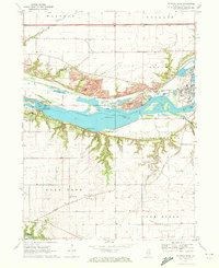 1970 Starved Rock1972 Print · USGSThe Illinois River valley in the early seventies reveals a landscape of deep canyons and heavy industry. Trace the ABANDONED Illinois and Michigan Canal and find landmarks like Buffalo Rock and the Deer Park Ch Cem.3 unique versions available
 - 1970 Map of Prairie Center, 1972 Print
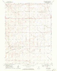 1970 Prairie Center1972 Print · USGSLaSalle County agriculture and township life are captured here in the early seventies, centered on the crossroads of Prairie Center. Genealogists and local historians can locate early burial sites like Gouldtown Cem and rural schoolhouses such as Waltham Sch.
End of results
Showing maps 1-2 of 2
Top cities near North Utica
- Streator historical maps
- Peru historical maps
- LaSalle historical maps
- La Salle historical maps
- Mendota historical maps
- Spring Valley historical maps
See more
Top neighborhoods of North Utica
Frequently asked questions
- What are the different types of historical maps available for North Utica?
- What is the oldest map of North Utica?
- Where can I purchase historical maps of North Utica for my home or office?
- Where can I download high-res historical maps of North Utica?
- Are there historical topographic maps available for North Utica?
- Is there historical aerial imagery available for North Utica?
- Where are historical maps of North Utica sourced from?