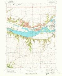
1970 Map of Starved Rock
USGS Topo · Published 1972About this map
Starved Rock State Park anchors this 1970s landscape, where the deeply incised canyons of the south bank meet the industrial and agricultural activity of the Illinois River valley. The map documents a complex geography of transition, featuring the ABANDONED Illinois and Michigan Canal and the active Chicago Rock Island and Pacific Railroad paralleling the river. The southern bluffs are heavily marked by dramatic geological features like French Canyon, Tonti Canyon, and the Cave-of-the-Winds, while the northern uplands show intensive resource extraction through numerous strip mines, claypits, and sandpits.
Find a feature on this map
56 named features on this map. Tap any name to fly to it.
Don’t see what you’re looking for? This feature index may not catch every label — zoom into the map to look around manually.
Map Details
Editions of this 1970 Starved Rock Map
3 editions found
Other maps of this area

1892 · Ottawa
USGS Topo · 1:62,500

1893 · Lasalle
USGS Topo · 1:62,500

1911 · La Salle
USGS Topo · 1:62,500

1913 · La Salle
USGS Topo · 1:62,500

1915 · Ottawa
USGS Topo · 1:62,500

1925 · Streator
USGS Topo · 1:62,500

1927 · Streator
USGS Topo · 1:62,500

1934 · Wenona
USGS Topo · 1:48,000

1939 · Wenona
USGS Topo · 1:62,500

1946 · Ottawa
USGS Topo · 1:62,500