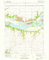
1970 Map of Starved Rock
USGS Topo · Published 1975About this map
Starved Rock State Park and Buffalo Rock State Park dominate this Illinois River landscape, where the water's path is marked by a sequence of dramatic canyons. From Wildcat Canyon and French Canyon in the west to Illinois Canyon and Horseshoe Canyon further east, the south bank reveals a geologically complex shoreline. The northern bank presents a starkly different character, defined by industrial activity including several large Strip Mines, Claypits, and the rail infrastructure of the Chicago Rock Island and Pacific Railroad.
Find a feature on this map
53 named features on this map. Tap any name to fly to it.
Don’t see what you’re looking for? This feature index may not catch every label — zoom into the map to look around manually.
Map Details
Editions of this 1970 Starved Rock Map
3 editions found
Other maps of this area

1892 · Ottawa
USGS Topo · 1:62,500

1893 · Lasalle
USGS Topo · 1:62,500

1911 · La Salle
USGS Topo · 1:62,500

1913 · La Salle
USGS Topo · 1:62,500

1915 · Ottawa
USGS Topo · 1:62,500

1925 · Streator
USGS Topo · 1:62,500

1927 · Streator
USGS Topo · 1:62,500

1934 · Wenona
USGS Topo · 1:48,000

1939 · Wenona
USGS Topo · 1:62,500

1946 · Ottawa
USGS Topo · 1:62,500