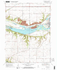
1970 Map of Starved Rock
USGS Topo · Published 1975About this map
The Illinois River corridor dominates this landscape, carving through sandstone bluffs to create the dramatic ravine systems of Starved Rock State Park and Buffalo Rock State Park. Notable canyons like Hennepin Canyon, La Salle Canyon, and Kaskaskia Canyon are mapped in detail alongside river features such as Delbridge Island and the Starved Rock Lock and Dam. The 1970 landscape reveals a heavy industrial presence adjacent to these natural landmarks, with an active Strip Mine, various sandpits, and the glass-manufacturing community of Naplate. Local infrastructure includes the Chicago Rock Island and Pacific railroad and the Old Railroad Grade north of the river. To the south, the rural character of Deer Park and Farm Ridge is anchored by Deer Park Ch, Deer Park Sch, and the village of Vermillionville along the Vermilion River.
Find a feature on this map
51 named features on this map. Tap any name to fly to it.
Don’t see what you’re looking for? This feature index may not catch every label — zoom into the map to look around manually.
Map Details
Editions of this 1970 Starved Rock Map
3 editions found
Other maps of this area

1892 · Ottawa
USGS Topo · 1:62,500

1893 · Lasalle
USGS Topo · 1:62,500

1911 · La Salle
USGS Topo · 1:62,500

1913 · La Salle
USGS Topo · 1:62,500

1915 · Ottawa
USGS Topo · 1:62,500

1925 · Streator
USGS Topo · 1:62,500

1927 · Streator
USGS Topo · 1:62,500

1934 · Wenona
USGS Topo · 1:48,000

1939 · Wenona
USGS Topo · 1:62,500

1946 · Ottawa
USGS Topo · 1:62,500