1950s Maps of Lee County, Illinois
Explore 6 historic maps of Lee County from the 1950s. These maps offer a rare glimpse into what life looked like during the 1950s — showing old roads, neighborhoods, homes, and landmarks that have changed or disappeared over time.
Whether you're researching your family's past, planning a metal detecting trip, or studying how Lee County's landscape evolved across the 1950s, these high-resolution maps are a powerful tool for exploring the history of this region.
- Focus on a specific era: All maps on this page are from the 1950s, giving you a focused view of this time period.
- See what’s changed: Compare century-old streets, trails, and buildings to today's modern landscape using overlays and satellite layers.
- Research with precision: Use these maps for genealogy, historical research, land use analysis, or educational projects.
- View, download, or print: Maps are fully viewable online in high resolution, and can be downloaded or printed for your own records.
Start exploring Lee County's history through authentic maps from the 1950s. This is your window into the past.
Lee County, IL maps
(6)- 1950 Map of Dixon, 1964 Print
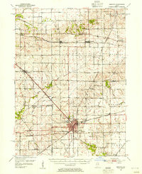
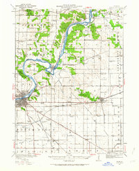 1950 Dixon1964 Print · USGSThe Rock River valley in the mid-twentieth century shows a landscape of busy river towns and dense rural school districts. Genealogists can locate family-named landmarks like Tealls Corners School, Emmert School, and the White Temple church.2 unique versions available
 - 1951 Map of Amboy, 1952 Print
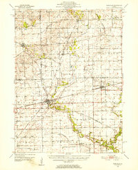
 1951 Amboy1952 Print · USGSNorthern Illinois during the early fifties reveals a landscape shaped by military industry and rail transport. Genealogists can locate family landmarks like Woodside Cem, Perkins Grove Ch, and the sprawling Green River Ordnance Plant.3 unique versions available
 - 1951 Map of Earlville, 1952 Print
 1951 Earlville1952 Print · USGSThe rural crossroads of north-central Illinois come to life in this early fifties survey of the area surrounding Earlville and Leland. Genealogists can trace family ties at the Baker Cem or St Clara Cem and locate vanished schoolhouses like Austin Sch.2 unique versions available
 - 1952 Map of Rochelle, 1954 Print
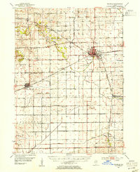 1952 Rochelle1954 Print · USGSOgle and Lee Counties in the early fifties reveal a landscape of thriving rural schools and critical rail junctions centered on Rochelle. Genealogists can trace local roots through numerous landmarks including Reynolds Ch, Twin Grove Cem, and Willow Center Sch.3 unique versions available
 - 1952 Map of Mendota, 1954 Print
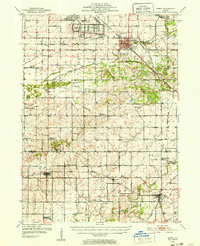
 1952 Mendota1954 Print · USGSMendota was a bustling railroad crossroads in the 1950s at the junction of three major lines. Genealogists can trace family roots through numerous country burial grounds and schoolhouses like Holy Cross Cem, Restland Cem, and Schlesinger Sch.3 unique versions available
 - 1958 Map of Aurora, 1969 Print
 1958 Aurora1969 Print · USGSNorthern Illinois in the late fifties shows a landscape of powerful river industry and expanding transport corridors. Genealogists and historians can trace the development of Aurora and Joliet or locate sites like the Elwood Ordnance Plant and Starved Rock.3 unique versions available
End of results
Showing maps 1-6 of 6
Frequently asked questions
- What are the different types of historical maps available for Lee County?
- What is the oldest map of Lee County?
- Where can I purchase historical maps of Lee County for my home or office?
- Where can I download high-res historical maps of Lee County?
- Are there historical topographic maps available for Lee County?
- Is there historical aerial imagery available for Lee County?
- Where are historical maps of Lee County sourced from?