1980s Maps of Lee County, Illinois
Explore 21 historic maps of Lee County from the 1980s. These maps offer a rare glimpse into what life looked like during the 1980s — showing old roads, neighborhoods, homes, and landmarks that have changed or disappeared over time.
Whether you're researching your family's past, planning a metal detecting trip, or studying how Lee County's landscape evolved across the 1980s, these high-resolution maps are a powerful tool for exploring the history of this region.
- Focus on a specific era: All maps on this page are from the 1980s, giving you a focused view of this time period.
- See what’s changed: Compare century-old streets, trails, and buildings to today's modern landscape using overlays and satellite layers.
- Research with precision: Use these maps for genealogy, historical research, land use analysis, or educational projects.
- View, download, or print: Maps are fully viewable online in high resolution, and can be downloaded or printed for your own records.
Start exploring Lee County's history through authentic maps from the 1980s. This is your window into the past.
Lee County, IL maps
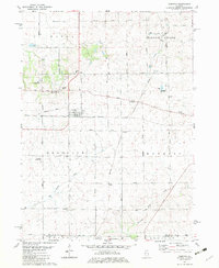
(21)- 1982 Map of Harmon
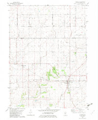
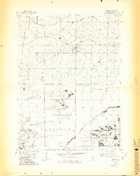 1982 Harmon1982 Print · USGSHarmon and Hamilton townships are shown in the early 1980s at a critical rail intersection in rural Lee County. Genealogists and local historians can trace early community life through landmarks like Holy Cross Ch, Centenary Cem, and the rail stop at Van Petten.3 unique versions available
 - 1982 Map of New Bedford
 1982 New Bedford1982 Print · USGSThe Illinois prairie of the early 1980s is captured here, showing the rural intersection of Bureau and Whiteside counties. Genealogists can locate family sites near Fairfield Greenville Cem, while the Indian Treaty Boundary offers a glimpse into early land division.
 - 1982 Map of Ohio
 1982 Ohio1982 Print · USGSThe Illinois prairie near the Bureau and Lee County line is captured in the early eighties as a landscape of grid-roads and rail. Genealogists and local historians can trace the Old Indian Treaty Boundary and find family sites at St Marys Cem or North Prairie Cem.
 - 1982 Map of Sublette
 1982 Sublette1982 Print · USGSNorthern Illinois prairie land is captured here in the early eighties, showcasing the intersection of rail and rural life. Genealogists can locate family-named routes and landmarks like Montavon Road or St Marys Cem near Sublette.
 - 1982 Map of Compton
 1982 Compton1982 Print · USGSNorthern Illinois prairie life in the early eighties is mapped here at the junction of the Burlington Northern and Chicago and North Western. Researchers can trace rural lineages through family landmarks like Fisk Cem and the small settlement of The Burg.
 - 1982 Map of Walnut
 1982 Walnut1982 Print · USGSThe village of Walnut and its surrounding townships are shown here in the early eighties, defined by the local rail lines and long-standing territorial lines. Genealogists and local historians can locate the Red Oak Ch, the Old Indian Treaty Boundary, and the small settlement of Smith.
 - 1982 Map of Walton
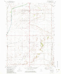
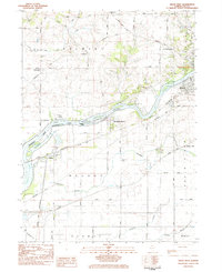
 1982 Walton1982 Print · USGSLee County agriculture meets industrial development in the early 1980s near the Green River and its managed wetlands. Trace family history at Williams Cem or locate rural landmarks like Union Ch and Maytown in this detailed quadrangle.
 - 1982 Map of Hahnaman
 1982 Hahnaman1982 Print · USGSWhiteside County in the early eighties shows an engineered landscape of prairie drainage and rail lines. Researchers can trace family-named roads like Mc Elvee Road and local sites like the Montmorency Sch and the Hennepin Canal Feeder.
 - 1982 Map of La Moille
 1982 La Moille1982 Print · USGSLa Moille and the Bureau County countryside appear here in the early 1980s, revealing a landscape defined by the Burlington Northern and the Old Indian Treaty Boundary. Genealogists and researchers can locate landmarks like Bache Memorial Chapel, Union Cem, and the small settlement of Van Orin.
 - 1982 Map of Mendota West
 1982 Mendota West1982 Print · USGSThe crossroads of the Bureau and La Salle county lines come alive in the early 1980s, showcasing the intersection of the Illinois Central Gulf and Burlington Northern railroads. Genealogists can trace family roots through Erbes Cem and Hetzler Cem, or locate landmarks like Blackstone Sch.
 - 1982 Map of Amboy, 1983 Print
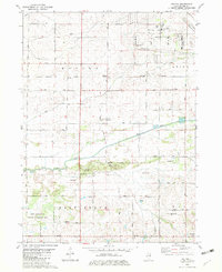
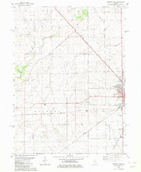
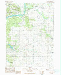
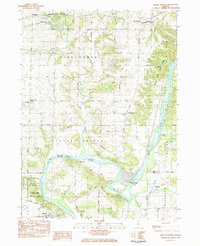
 1982 Amboy1983 Print · USGSThe rail-and-river landscape of Lee County is captured here in the early eighties as the town of Amboy sits at a major rail junction. Genealogists and local historians can trace family plots at Prairie Repose Cem or explore the rural outskirts of Binghamton and Sublette.
 - 1983 Map of Polo, 1984 Print
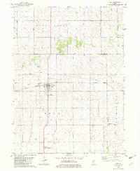
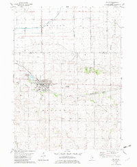
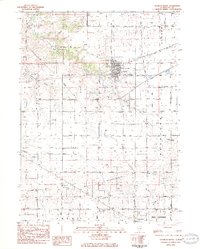
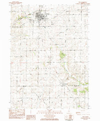 1983 Polo1984 Print · USGSDuring the early 1980s, the rural townships of Ogle and Lee Counties maintained a steady landscape of family farms and small-town centers like Polo. Researchers can locate several burial grounds including Fairmont Cem and trace old country schools like Congress Sch.
 - 1983 Map of Sterling, 1984 Print
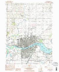 1983 Sterling1984 Print · USGSSterling and Rock Falls are shown here at the Rock River in the early eighties, joined by a network of bridges and railroads. Researchers can trace neighborhood growth through local landmarks like Newman Central High Sch, the Indian Mounds Historic Site, and Oak Knoll Cem.2 unique versions available
 - 1983 Map of Dixon West, 1984 Print
 1983 Dixon West1984 Print · USGSDixon and its western environs are shown in the early 1980s as the regional rail and river network continued to shape Lee County. Researchers can trace family sites at Nelson Cem and Rock Ridge Cem or follow the path of the Hennepin Canal.
 - 1983 Map of Daysville, 1984 Print
 1983 Daysville1984 Print · USGSOgle County's agricultural heartland and the bluffs of the Rock River are captured here in the early 1980s. Genealogists can trace family names and local landmarks through sites like Daysville Cem, Lighthouse Ch, and the settlement of Watertown.
 - 1983 Map of Hazelhurst, 1984 Print
 1983 Hazelhurst1984 Print · USGSWhiteside and Ogle counties are captured here in the early eighties, showcasing a landscape of creek-side hamlets and rural parish life. Genealogists can trace family footprints at Nichols Cem or follow the rails of the Burlington Northern through Hazelhurst.
 - 1983 Map of Grand Detour, 1984 Print
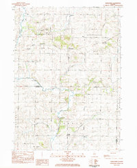
 1983 Grand Detour1984 Print · USGSOgle and Lee County are captured in the early eighties as the Rock River winds through the historic horseshoe bend at Grand Detour. Genealogists and local historians can trace rural sites like Kingdom, the Pine Creek Cemetery, and the Townhall north of the river.
 - 1983 Map of Franklin Grove, 1984 Print
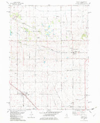
 1983 Franklin Grove1984 Print · USGSFranklin Grove and the surrounding Lee County townships are captured in the early 1980s, showcasing a mix of established village life and rural farmland. Researchers can trace family history at Temperance Hill Cem, locate the County 4-H Center, or explore the local grid of Franklin Grove.
 - 1983 Map of Dixon East, 1984 Print
 1983 Dixon East1984 Print · USGSDixon and its surrounding townships are captured in the early 1980s as the community expanded along the Rock River. Researchers can locate historic rural burial sites like De Wolf Cem and trace the rail-side growth of Nachusa and Eldena.
 - 1985 Map of Dixon
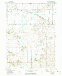
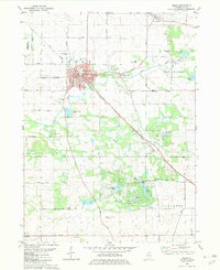
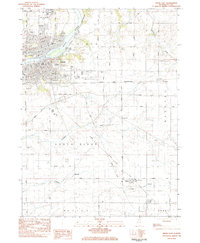
 1985 Dixon1985 Print · USGSNorth-central Illinois in the mid-eighties was a land of river cities and expansive prairies defined by rail lines and private airfields. Researchers can locate family landmarks like Oakwood Cem, the Sword Landing Strip, and Sauk Valley College while tracing the C & N W railroad.2 unique versions available
 - 1985 Map of Aurora, 1989 Print
 1985 Aurora1989 Print · USGSNortheastern Illinois is captured in the mid-1980s as suburban growth began to bridge the gap between the Fox River cities and the outer prairies. Researchers can trace the development of Naperville and Aurora or locate rural landmarks like Fairview Cem and the Illinois and Michigan Canal.
End of results
Showing maps 1-21 of 21
Frequently asked questions
- What are the different types of historical maps available for Lee County?
- What is the oldest map of Lee County?
- Where can I purchase historical maps of Lee County for my home or office?
- Where can I download high-res historical maps of Lee County?
- Are there historical topographic maps available for Lee County?
- Is there historical aerial imagery available for Lee County?
- Where are historical maps of Lee County sourced from?