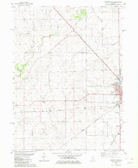
1982 Map of Mendota West
USGS Topo · Published 1982About this map
The city of Mendota serves as the focal point of this Illinois survey, where the Burlington Northern and Illinois Central Gulf rail lines intersect. This 1980s landscape is defined by its transition from organized agricultural townships like Sublette and Clarion to the more concentrated industrial and residential hub of Mendota. A significant historical marker, the Old Indian Boundary, cuts across the lower half of the quadrangle, reflecting early surveying lines that shaped land ownership in Bureau and La Salle Counties. Small, scattered settlements such as Henkel, Wendel, and Clarion appear alongside rural aviation sites like Grandpas Farm Airport and the Keutzer Landing Strip. Family history is preserved in several rural plots, including Erbes Cem and Hetzler Cem, while local institutions like Blackstone Sch and the Mendota Bible Ch anchor the community's mid-century social fabric.
Find a feature on this map
39 named features on this map. Tap any name to fly to it.
Don’t see what you’re looking for? This feature index may not catch every label — zoom into the map to look around manually.
Map Details
Editions of this 1982 Mendota West Map
This is the sole edition of this map. No revisions or reprints were ever made.
Other maps of this area

1893 · Hennepin
USGS Topo · 1:62,500

1893 · Lasalle
USGS Topo · 1:62,500

1909 · Hennepin
USGS Topo · 1:62,500

1911 · La Salle
USGS Topo · 1:62,500

1911 · Hennepin
USGS Topo · 1:62,500

1913 · La Salle
USGS Topo · 1:62,500

1947 · La Salle
USGS Topo · 1:62,500

1951 · Amboy
USGS Topo · 1:62,500

1952 · Mendota
USGS Topo · 1:62,500

1958 · Aurora
USGS Topo · 1:250,000