1930s Maps of Moultrie County, Illinois
Explore 5 historic maps of Moultrie County from the 1930s. These maps offer a rare glimpse into what life looked like during the 1930s — showing old roads, neighborhoods, homes, and landmarks that have changed or disappeared over time.
Whether you're researching your family's past, planning a metal detecting trip, or studying how Moultrie County's landscape evolved across the 1930s, these high-resolution maps are a powerful tool for exploring the history of this region.
- Focus on a specific era: All maps on this page are from the 1930s, giving you a focused view of this time period.
- See what’s changed: Compare century-old streets, trails, and buildings to today's modern landscape using overlays and satellite layers.
- Research with precision: Use these maps for genealogy, historical research, land use analysis, or educational projects.
- View, download, or print: Maps are fully viewable online in high resolution, and can be downloaded or printed for your own records.
Start exploring Moultrie County's history through authentic maps from the 1930s. This is your window into the past.
Moultrie County, IL maps
(5)- 1933 Map of Decatur
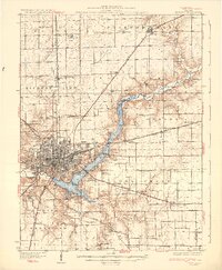 1933 Decatur1933 Print · USGSThe rail-and-river hub of Decatur is captured here in the early thirties, showing a landscape defined by industrial growth and rural school districts. Genealogists can trace family landmarks like Antioch Ch or dozens of local schoolhouses including Blue Door Sch and Mound Sch.3 unique versions available
 - 1934 Map of Mattoon, 1967 Print
 1934 Mattoon1967 Print · USGSThe rail hubs and rural townships of East Central Illinois are captured here in the mid-1930s. Genealogists and local historians can trace the foundations of Mattoon and Neoga while locating family landmarks like Old Bethel Ch or the Little Brick Sch.2 unique versions available
 - 1935 Map of Arcola
 1935 Arcola1935 Print · USGSCentral Illinois farming communities thrived along the Illinois Central and Pennsylvania rail lines in the 1930s. Genealogists can trace family roots through numerous rural landmarks like Yoder Cem, Quinn Chapel, and Pulltight Sch.3 unique versions available
 - 1935 Map of Sullivan
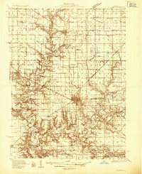 1935 Sullivan1935 Print · USGSMid-depression Moultrie County is captured here as a thriving network of small school districts and railroad sidings. Genealogists can trace family roots through dozens of local landmarks like Stringtown Sch, the Masonic Home, and Campfield Cem.3 unique versions available
 - 1937 Map of Mattoon
 1937 Mattoon1937 Print · USGSThe rail hubs of Mattoon and Neoga are shown in the late 1930s, surrounded by a dense network of country schools and family cemeteries. Trace ancestral roots at Aetna Etna PO, Johnstown, or the many rural schoolhouses like South Loxa Sch.3 unique versions available
End of results
Showing maps 1-5 of 5
Top cities of Moultrie County
- Sullivan historical maps
- Bethany historical maps
- Lovington historical maps
- Dalton City historical maps
- Gays historical maps
- Allenville historical maps
Frequently asked questions
- What are the different types of historical maps available for Moultrie County?
- What is the oldest map of Moultrie County?
- Where can I purchase historical maps of Moultrie County for my home or office?
- Where can I download high-res historical maps of Moultrie County?
- Are there historical topographic maps available for Moultrie County?
- Is there historical aerial imagery available for Moultrie County?
- Where are historical maps of Moultrie County sourced from?