1980s Maps of Moultrie County, Illinois
Explore 15 historic maps of Moultrie County from the 1980s. These maps offer a rare glimpse into what life looked like during the 1980s — showing old roads, neighborhoods, homes, and landmarks that have changed or disappeared over time.
Whether you're researching your family's past, planning a metal detecting trip, or studying how Moultrie County's landscape evolved across the 1980s, these high-resolution maps are a powerful tool for exploring the history of this region.
- Focus on a specific era: All maps on this page are from the 1980s, giving you a focused view of this time period.
- See what’s changed: Compare century-old streets, trails, and buildings to today's modern landscape using overlays and satellite layers.
- Research with precision: Use these maps for genealogy, historical research, land use analysis, or educational projects.
- View, download, or print: Maps are fully viewable online in high resolution, and can be downloaded or printed for your own records.
Start exploring Moultrie County's history through authentic maps from the 1980s. This is your window into the past.
Moultrie County, IL maps
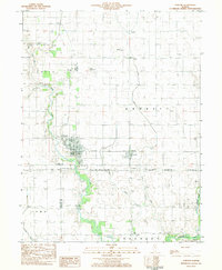
(15)- 1981 Map of Windsor, 1982 Print
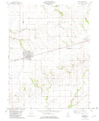 1981 Windsor1982 Print · USGSShelby and Moultrie counties are captured here in the early eighties, centered on the railroad town of Windsor. Local historians can trace family roots through numerous remote burial sites like Lookout Point Cem, Cochran Cem, and the rural community of Sexson Corner.
 - 1983 Map of Hammond
 1983 Hammond1983 Print · USGSThe rural border of Piatt and Moultrie counties is captured here in the early 1980s as a landscape of grid-patterned farms and vital drainage works. Local researchers can locate Hammond Cem, the Jr High Sch in Hammond, and the small settlement of Pierson along the Baltimore and Ohio tracks.
 - 1983 Map of La Place
 1983 La Place1983 Print · USGSThe grain-and-rail landscape of central Illinois is captured here in the early eighties. Genealogists and local historians can trace the foundations of LaPlace and Lake City, alongside rural landmarks like Turner Cem and Stringtown.
 - 1983 Map of Cooks Mills
 1983 Cooks Mills1983 Print · USGSColes County at the start of the eighties shows a landscape of river-bottom farms and active extraction. Researchers can locate family landmarks like Quinn Chapel and Smith Cem or trace the path of the Illinois Central Gulf railroad.
 - 1983 Map of Arthur
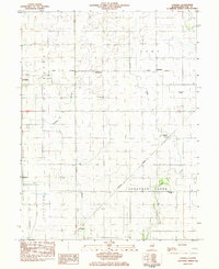
 1983 Arthur1983 Print · USGSThe Douglas and Moultrie County borderlands come to life in the early 1980s, centered on the rail junction at Arthur. Researchers can trace old rural schoolhouses like Prairie Lane Sch, numerous family burial sites including Yoder Cem, and the specialized Cooks Mills Oil Field.
 - 1983 Map of Sullivan
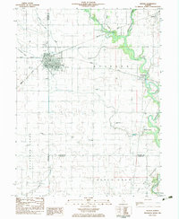
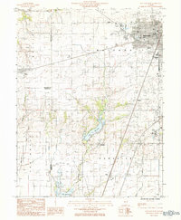
 1983 Sullivan1983 Print · USGSThe town of Sullivan and the eastern shores of Lake Shelbyville are captured here in the early 1980s. Researchers can trace local heritage through the Masonic Home, Jonathan Creek Ch, and family sites like Bolin Cem and Purvis Cem.
 - 1983 Map of Lovington
 1983 Lovington1983 Print · USGSLovington and Bethany are the primary population centers of this central Illinois landscape in the early 1980s. Genealogists can locate several burial sites like Mitchell Cem and Wright Cem, or trace the path of the Illinois Central Gulf railroad.
 - 1983 Map of Cadwell
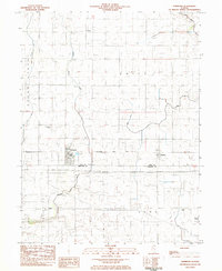
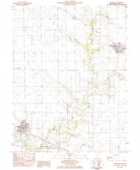
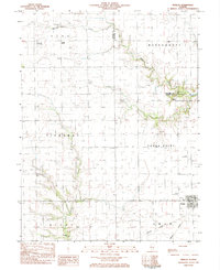
 1983 Cadwell1983 Print · USGSMoultrie County at the start of the eighties shows a classic Illinois agricultural landscape structured by rail lines and small prairie towns. Genealogists and historians can locate rural landmarks like Seass Cem, the Townhall at Fairbanks, and the siding at Chipps.
 - 1983 Map of Atwood
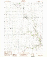
 1983 Atwood1983 Print · USGSAtwood and the surrounding prairie towns of Garrett and Bourbon are captured here in the early eighties. Genealogists and local historians can trace family roots through several rural landmarks, including Mackville Cem, Taylor Cem, and the Zion Ch community.
 - 1983 Map of Kirksville
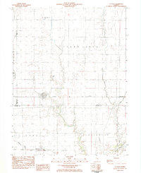
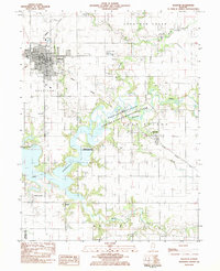
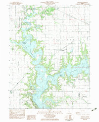 1983 Kirksville1983 Print · USGSThe Lake Shelbyville area is shown here in the early eighties as the reservoir reshaped the Moultrie and Shelby county lines. Genealogists and local historians can trace rural roots through landmarks like Henderson Cem, Oak Grove Ch, and the village of Kirksville.
 - 1983 Map of Findlay
 1983 Findlay1983 Print · USGSShelby County in the early eighties shows a landscape of steady agricultural life centered on Findlay. Genealogists and local historians can trace family locations near Prairie Home Cem, St Marys Ch, or along the Missouri Pacific rail corridor.
 - 1983 Map of Dalton City
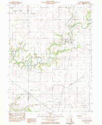
 1983 Dalton City1983 Print · USGSDalton City and its surrounding townships are shown here in the early eighties, centered on the vital grain-shipping corridor of the Illinois Central Gulf railroad. Researchers can locate family landmarks like New Hope Cem, the small settlement of Reddy, and Walker Cem.
 - 1984 Map of Mattoon West, 1985 Print
 1984 Mattoon West1985 Print · USGSThe western edge of Mattoon and its neighboring rural townships are captured here in the early 1980s. Local researchers can trace the development of Lake Land Jr College, the expansion of the Oil Field, and rail-side settlements like Gays and Etna.
 - 1985 Map of Decatur
 1985 Decatur1985 Print · USGSCentral Illinois farming and rail hubs thrive in the mid-1980s as Decatur anchors a sprawling network of track and timber. Trace the paths of the Sangamon River and the Illinois Central Gulf RR through old towns like Cerro Gordo and Bement.2 unique versions available
 - 1986 Map of Effingham
 1986 Effingham1986 Print · USGSCentral Illinois during the mid-eighties was a hub of rail travel and water recreation centered on the new reservoirs. Genealogists and historians can trace the rural landscape between Mattoon and Effingham, locating landmarks like St Paul Ch and Eagle Creek State Park.2 unique versions available
End of results
Showing maps 1-15 of 15
Top cities of Moultrie County
- Sullivan historical maps
- Bethany historical maps
- Lovington historical maps
- Dalton City historical maps
- Gays historical maps
- Allenville historical maps
Frequently asked questions
- What are the different types of historical maps available for Moultrie County?
- What is the oldest map of Moultrie County?
- Where can I purchase historical maps of Moultrie County for my home or office?
- Where can I download high-res historical maps of Moultrie County?
- Are there historical topographic maps available for Moultrie County?
- Is there historical aerial imagery available for Moultrie County?
- Where are historical maps of Moultrie County sourced from?