1940s Maps of Moultrie County, Illinois
Explore 5 historic maps of Moultrie County from the 1940s. These maps offer a rare glimpse into what life looked like during the 1940s — showing old roads, neighborhoods, homes, and landmarks that have changed or disappeared over time.
Whether you're researching your family's past, planning a metal detecting trip, or studying how Moultrie County's landscape evolved across the 1940s, these high-resolution maps are a powerful tool for exploring the history of this region.
- Focus on a specific era: All maps on this page are from the 1940s, giving you a focused view of this time period.
- See what’s changed: Compare century-old streets, trails, and buildings to today's modern landscape using overlays and satellite layers.
- Research with precision: Use these maps for genealogy, historical research, land use analysis, or educational projects.
- View, download, or print: Maps are fully viewable online in high resolution, and can be downloaded or printed for your own records.
Start exploring Moultrie County's history through authentic maps from the 1940s. This is your window into the past.
Moultrie County, IL maps
(5)- 1940 Map of Sullivan
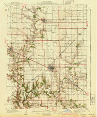 1940 Sullivan1940 Print · USGSCentral Illinois is seen here just before the Second World War, showing a landscape defined by small townships and an extensive rail network. Genealogists and local researchers can locate dozens of country schools like Hewitt Sch and Titus Sch, or trace family sites such as Wright Cem and the Masonic Home.2 unique versions available
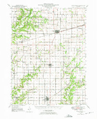
 - 1940 Map of Arcola
 1940 Arcola1940 Print · USGSThe Douglas and Coles County borderlands come alive in this pre-war portrait of central Illinois agricultural life. Researchers can trace dozens of rural school sites such as Pulltight Sch and Little Red Sch, alongside old rail corridors like the Illinois Central.
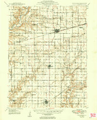
 - 1947 Map of Stewardson, 1965 Print
 1947 Stewardson1965 Print · USGSMid-century Shelby County is mapped here as a thriving agricultural landscape defined by its rural schools and rail junctions. Genealogists can locate family landmarks like Rincker Cem and East Salem School, or trace the rail lines through Stewardson.
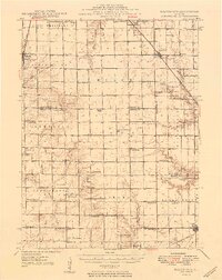
 - 1949 Map of Stewardson
 1949 Stewardson1949 Print · USGSShelby and Moultrie counties thrive as a vital rail and farming hub at the close of the 1940s. Researchers can locate dozens of country landmarks like Jordan Chapel, Rincker Cem, and North Liberty Sch along the region's busy rail lines.2 unique versions available
 - 1949 Map of Dalton City
 1949 Dalton City1949 Print · USGSCentral Illinois agriculture and rail transit are documented here just after the war, showing the dense network of one-room schools and country churches. Genealogists can locate family landmarks like Sanner Chapel, New Hope Cem, and Penn Consolidated Sch.2 unique versions available
End of results
Showing maps 1-5 of 5
Top cities of Moultrie County
- Sullivan historical maps
- Bethany historical maps
- Lovington historical maps
- Dalton City historical maps
- Gays historical maps
- Allenville historical maps
Frequently asked questions
- What are the different types of historical maps available for Moultrie County?
- What is the oldest map of Moultrie County?
- Where can I purchase historical maps of Moultrie County for my home or office?
- Where can I download high-res historical maps of Moultrie County?
- Are there historical topographic maps available for Moultrie County?
- Is there historical aerial imagery available for Moultrie County?
- Where are historical maps of Moultrie County sourced from?