1970s Maps of Moultrie County, Illinois
Explore 2 historic maps of Moultrie County from the 1970s. These maps offer a rare glimpse into what life looked like during the 1970s — showing old roads, neighborhoods, homes, and landmarks that have changed or disappeared over time.
Whether you're researching your family's past, planning a metal detecting trip, or studying how Moultrie County's landscape evolved across the 1970s, these high-resolution maps are a powerful tool for exploring the history of this region.
- Focus on a specific era: All maps on this page are from the 1970s, giving you a focused view of this time period.
- See what’s changed: Compare century-old streets, trails, and buildings to today's modern landscape using overlays and satellite layers.
- Research with precision: Use these maps for genealogy, historical research, land use analysis, or educational projects.
- View, download, or print: Maps are fully viewable online in high resolution, and can be downloaded or printed for your own records.
Start exploring Moultrie County's history through authentic maps from the 1970s. This is your window into the past.
Moultrie County, IL maps
(2)- 1975 Map of Tuscola SW, 1977 Print
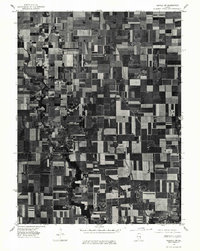 1975 Tuscola SW1977 Print · USGSMid-century Illinois farmland is captured in sharp detail during the autumn of 1975, showing the structured grid of the heartland. Genealogists and local historians can trace the exact footprints of homes and buildings in Atwood and Garrett or follow the banks of the Kaskaskia River.
 - 1975 Map of Bement SE, 1977 Print
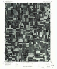 1975 Bement SE1977 Print · USGSPiatt County farmland is captured in sharp aerial detail during the mid-seventies, showing the precise layout of the central Illinois agricultural grid. Researchers can trace the development of small rural centers like Hammond and Pierson among the fields near Lake and Fork.
End of results
Showing maps 1-2 of 2
Top cities of Moultrie County
- Sullivan historical maps
- Bethany historical maps
- Lovington historical maps
- Dalton City historical maps
- Gays historical maps
- Allenville historical maps
Frequently asked questions
- What are the different types of historical maps available for Moultrie County?
- What is the oldest map of Moultrie County?
- Where can I purchase historical maps of Moultrie County for my home or office?
- Where can I download high-res historical maps of Moultrie County?
- Are there historical topographic maps available for Moultrie County?
- Is there historical aerial imagery available for Moultrie County?
- Where are historical maps of Moultrie County sourced from?