1970s Maps of Pike County, Illinois
Explore 11 historic maps of Pike County from the 1970s. These maps offer a rare glimpse into what life looked like during the 1970s — showing old roads, neighborhoods, homes, and landmarks that have changed or disappeared over time.
Whether you're researching your family's past, planning a metal detecting trip, or studying how Pike County's landscape evolved across the 1970s, these high-resolution maps are a powerful tool for exploring the history of this region.
- Focus on a specific era: All maps on this page are from the 1970s, giving you a focused view of this time period.
- See what’s changed: Compare century-old streets, trails, and buildings to today's modern landscape using overlays and satellite layers.
- Research with precision: Use these maps for genealogy, historical research, land use analysis, or educational projects.
- View, download, or print: Maps are fully viewable online in high resolution, and can be downloaded or printed for your own records.
Start exploring Pike County's history through authentic maps from the 1970s. This is your window into the past.
Pike County, IL maps
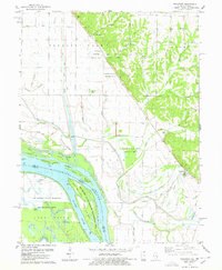
(11)- 1971 Map of Hannibal East, 1973 Print
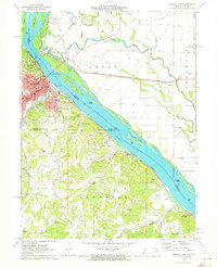 1971 Hannibal East1973 Print · USGSThe Missouri riverfront at Hannibal was a bustling hub of rail and river commerce in the early 1970s. Genealogists and historians can locate legacy sites like Mark Twain Cave, Antioch Ch, and the numerous quarries that defined the local economy.
 - 1971 Map of Marblehead, 1973 Print
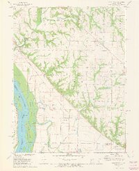 1971 Marblehead1973 Print · USGSThe Illinois riverfront south of Quincy was a landscape of managed floodplains and scattered settlements in the early 1970s. Trace family history at Craigtown Cem or follow the old Burlington Northern line through Marblehead and Bluff Hall.2 unique versions available
 - 1975 Map of Meredosia SE, 1976 Print
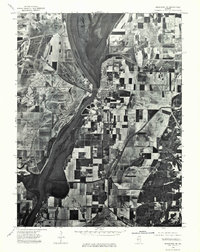 1975 Meredosia SE1976 Print · USGSThe Illinois River valley in the mid-1970s shows a landscape of riverfront commerce and productive floodplains. Genealogists and local historians can trace the footprints of Meredosia, Naples, and the edge of Bluffs as they appeared decades ago.
 - 1975 Map of Pittsfield SE, 1976 Print
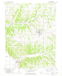
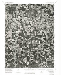 1975 Pittsfield SE1976 Print · USGSPike County farmland and rural settlements are captured in high detail mid-decade during this 1970s aerial survey. Genealogists and local historians can trace the precise 1975 footprints of Pittsfield and the smaller community of Martinsburg.
 - 1978 Map of Rockport
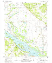
 1978 Rockport1978 Print · USGSThe Mississippi River bottomlands in the late seventies reveal an intricate network of drainage ditches and family-owned lands near Rockport. Researchers can trace old cemeteries like Hornback Cem, find the Stillhouse landmark, and explore the islands of the Ted Shanks State Wildlife Management Area.
 - 1978 Map of Ashburn
 1978 Ashburn1978 Print · USGSNortheastern Missouri river life in the late seventies is defined by the shifting channels and islands where the Salt and Mississippi meet. Researchers can trace family history through many rural burial sites like Busch Cem and Early Cem or locate old river landings such as Mundy Landing.
 - 1978 Map of Pleasant Hill West
 1978 Pleasant Hill West1978 Print · USGSIn the mid-1970s, the Mississippi River bottomlands were a complex mix of wildlife refuges and rail-driven settlements. You can trace family roots at Wells Cem or explore the river infrastructure near Pleasant Hill and Atlas.2 unique versions available
 - 1978 Map of Hull
 1978 Hull1978 Print · USGSThe Mississippi River bottomlands and Pike County bluffs are shown in detail during the late 1970s. Genealogists and historians can trace family burial sites like Journey Cem and House Cem or locate river engineering at Lock and Dam No 22.
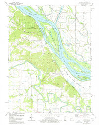
 - 1978 Map of Louisiana
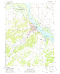 1978 Louisiana1978 Print · USGSThe river town of Louisiana, Missouri, is shown here in the late seventies at its busy confluence with the Mississippi. Genealogists and local historians can trace family locations at Riverview Cem, Bethany Cem, and the historic Meriwether Sch.2 unique versions available
 - 1978 Map of Barry
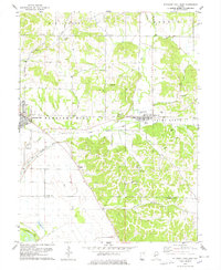
 1978 Barry1978 Print · USGSWestern Illinois farmland and creek valleys are captured here in the late seventies. Family historians can locate numerous rural burial grounds like Woodruff Cem and Story Point Cem or trace the Norfolk and Western rail line near Barry.
 - 1978 Map of Pleasant Hill East
 1978 Pleasant Hill East1978 Print · USGSPike and Calhoun Counties come into focus in the late 1970s as agricultural life meets the rugged ridge-and-valley terrain. Genealogists can locate family landmarks like Mason Cemetery or Carrollton Ridge Church while tracing the ILLINOIS CENTRAL GULF rail line.
End of results
Showing maps 1-11 of 11
Top cities of Pike County
- Pittsfield historical maps
- Barry historical maps
- Griggsville historical maps
- Pleasant Hill historical maps
- Atlas historical maps
- Montezuma historical maps
See more
Frequently asked questions
- What are the different types of historical maps available for Pike County?
- What is the oldest map of Pike County?
- Where can I purchase historical maps of Pike County for my home or office?
- Where can I download high-res historical maps of Pike County?
- Are there historical topographic maps available for Pike County?
- Is there historical aerial imagery available for Pike County?
- Where are historical maps of Pike County sourced from?