Old Maps of Pike County, Illinois for Academic Research
Study the evolution of Pike County with 194 high-resolution historic maps. Whether you're teaching, researching, or modeling changes in land use, these maps provide essential visual documentation of urban, environmental, and geographic change.
- Analyze long-term change: Track patterns in development, transportation, and natural features.
- Ideal for environmental or urban studies: Support academic projects with primary historical map data.
- Use in the classroom or lab: Educators and researchers rely on these maps to bring historical context to life.
These maps are a powerful tool for teaching, research, and visualizing how Pike County has changed over the decades.
Pike County, IL maps
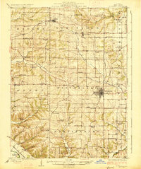
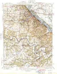
(194)- 1890 Map of Louisiana
 1890 Louisiana1890 Print · USGSUpper Missouri and Illinois river country in the 1890s is captured here at the height of the steam-rail era. Genealogists can trace family roots through old rural outposts like New Harmony, Prairieville, and the transit hub at Bowling Green.5 unique versions available
 - 1924 Map of Griggsville, 1959 Print
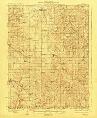
 1924 Griggsville1959 Print · USGSPike and Scott counties are captured during the mid-1920s as the Illinois River and Wabash RR defined local commerce. Researchers can trace rural life through dozens of named landmarks like Brush College School, Bethel Church, and Sleight Pond.2 unique versions available
 - 1925 Map of Quincy
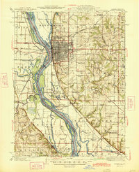
 1925 Quincy1925 Print · USGSQuincy and its Mississippi River hinterlands are captured in the mid-1920s, showing a landscape defined by river navigation and rail transport. Genealogists can locate dozens of country schools and churches, from St Ludgerus School to Zion Church and the Soldiers Home.2 unique versions available
 - 1925 Map of Liberty, 1972 Print
 1925 Liberty1972 Print · USGSWestern Illinois in the 1920s was a landscape of tightly knit farming communities and country crossroads. Genealogists and researchers can trace family roots through dozens of local landmarks like St Joseph School, Mt Pleasant Church, and the village of Plainville.
 - 1926 Map of Griggsville
 1926 Griggsville1926 Print · USGSThe Illinois River valley in the 1920s is captured here at the height of its rail-and-river economy. Genealogists and historians can trace dozens of rural schools and landmarks including Brush College School, Bethel Church, and the Wabash RR corridor.2 unique versions available
 - 1926 Map of Pittsfield
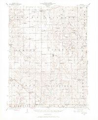
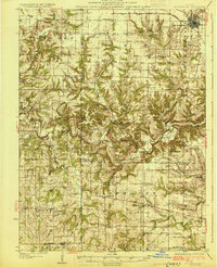
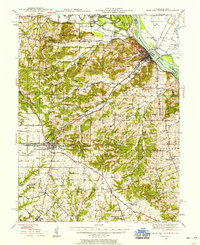
 1926 Pittsfield1926 Print · USGSPike County in the mid-twenties is a landscape of thriving rural school districts and small rail-side hamlets. Genealogists can locate family schoolhouses like Philadelphia School and Walnut Grove School or trace the early paths of the Wabash railroad through Pittsfield and Dutton.3 unique versions available
 - 1926 Map of Mt Sterling, 1970 Print
 1926 Mt Sterling1970 Print · USGSWestern Illinois at the mid-twenties reveals a landscape of ridge-top farms and creek-bottom crossings across Brown and Pike counties. You can trace the locations of dozens of vanished rural schoolhouses like Pea Green Sch and old river fords including Wilson Ford.
 - 1927 Map of Liberty
 1927 Liberty1927 Print · USGSAdams County’s rural townships are captured here during the mid-1920s, showing a landscape of small agricultural settlements and tight-knit communities. Family historians can locate dozens of country schools and churches, including Seigel School, Tandy School, and Pleasant Grove Church.2 unique versions available
 - 1928 Map of Meredosia, 1958 Print
 1928 Meredosia1958 Print · USGSThe Illinois River valley in the late 1920s was a bustling corridor of river locks, pumping stations, and rail lines. Genealogists and local historians can trace family roots through numerous rural landmarks like Ham Sch, Reich Landing, and the Perry Spring's Sta rail stop.2 unique versions available
 - 1929 Map of Mt Sterling
 1929 Mt Sterling1929 Print · USGSIn the late 1920s, the borderlands of Brown and Pike counties were defined by a dense network of country schools and creek crossings. Genealogists can trace family farms and local hubs like Pea Green Sch, Fishhook, and Mountain View Ch, or locate the historic Shinnebarger Bridge on McKee Creek.2 unique versions available
 - 1930 Map of Pearl
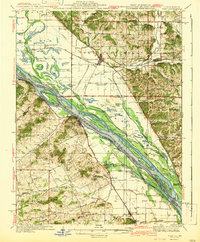
 1930 Pearl1930 Print · USGSThe Illinois River valley in the late 1920s shows a landscape of river-bottom farms and rugged bluff-top settlements. Genealogists can locate family landmarks like Miller Cem, Farmers Ridge Ch, and schools such as Summit Grove Sch or Village Green Sch.3 unique versions available
 - 1930 Map of Nebo
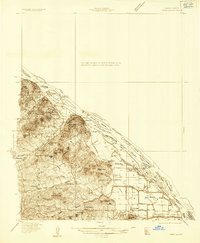
 1930 Nebo1930 Print · USGSThe Mississippi River bottomlands and Pike County bluffs are shown here in the late twenties, featuring a landscape of sloughs and rail-dependent towns. Trace family roots at Wildcat Cem or locate rural landmarks like Riprap Landing and Old Baptist Sch.
 - 1931 Map of Barry
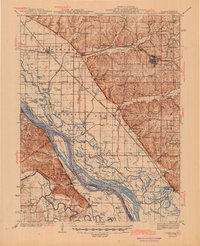
 1931 Barry1931 Print · USGSPike County bottomlands along the Mississippi River are shown here in the late twenties and early thirties, just as drainage projects transformed the landscape. Genealogists and local historians can trace rural school locations like Guss Sch and Munger Sch, or find family burials at Money Cem and Blackjack Cem.
 - 1931 Map of Meredosia
 1931 Meredosia1931 Print · USGSThe Illinois River valley in the late twenties is captured here at a peak of rail and river activity. Genealogists can trace family roots through numerous country schools like Sand Ridge Sch and the important La Grange Locks complex.2 unique versions available
 - 1932 Map of Hannibal
 1932 Hannibal1932 Print · USGSAlong the Mississippi River in the early 1930s, this survey captures the riverfront from Hannibal across to the Illinois bottomlands. Researchers can trace the river rail crossings of the WABASH and locate rural landmarks like Bird Slough Sch and the CHENALE ECARTE CLUB.4 unique versions available
 - 1934 Map of Nebo
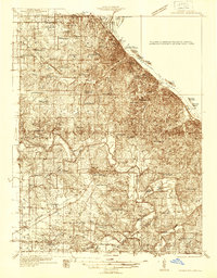
 1934 Nebo1934 Print · USGSThe Mississippi River borderlands in the mid-1930s reveal a landscape of river-and-rail commerce and high-ground settlements. Researchers can trace family history through the locations of Corinth Cem, the Greenwing Club, and rural schoolhouses like Farris Sch.4 unique versions available
 - 1936 Map of Hannibal
 1936 Hannibal1936 Print · USGSMid-century Hannibal and New London are shown during a transitional era of river commerce and early aviation. Researchers can trace the paths of the Burlington railroad or find ancestral landmarks like Withers Mill and Mt Olivet Cem.2 unique versions available
 - 1936 Map of Barry
 1936 Barry1936 Print · USGSThe Mississippi River valley in the mid-1930s reveals a complex network of island chutes and railroad settlements. Genealogists and historians can trace old river crossings like Stouts Ford and find vanished local school districts such as Love Sch and Hawk Creek Sch.2 unique versions available
 - 1937 Map of Bowling Green, 1958 Print
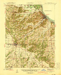
 1937 Bowling Green1958 Print · USGSPike County at the height of its rail-and-river era shows a landscape of productive orchards and small rural hamlets. Local researchers can trace the footprint of the Stark Nursery, follow the Chicago and Alton RR, and locate numerous old schools like Vine Hill Sch or the County Farm.2 unique versions available
 - 1940 Map of Bowling Green
 1940 Bowling Green1940 Print · USGSPike County at the end of the Depression reveals a landscape tied to the Mississippi River and a thriving rail network. Genealogists can trace family roots through dozens of rural landmarks like St Clement, Stark Nursery, and the Noix Creek Cem.2 unique versions available
 - 1942 Map of Nebo
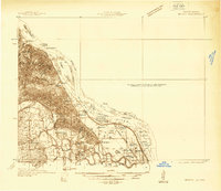
 1942 Nebo1942 Print · USGSThe Mississippi River floodplain and the rising knobs of Missouri appear here as they were in the early 1940s. Genealogists can trace a dense network of rural landmarks, from Salem Sch and Corinth Ch to the riverfront at Clarksville and Annada.2 unique versions available
 - 1944 Map of Barry
 1944 Barry1944 Print · USGSPike County's river-bottoms and bluffs are captured here in the mid-1940s, showing the complex interaction between the river and the rail lines. Genealogists and local historians can trace rural school locations like Wilke Chapel Sch and Buckeye Sch, or explore old landings such as Cincinnati Landing.2 unique versions available
 - 1944 Map of Quincy, 1954 Print
 1944 Quincy1954 Print · USGSQuincy and the Mississippi River valley are captured in the 1940s, showing a landscape defined by rail lines and rural parish schools. Researchers can trace the riverfront at Marion City, the grounds of the Soldiers Home, and historic sites like Zion Church.5 unique versions available
 - 1945 Map of Hannibal
 1945 Hannibal1945 Print · USGSMid-century Hannibal is captured here as a bustling Mississippi river port and railroad crossroads just after the war. Local historians can trace family roots through dozens of rural landmarks like Mt Zion Cem, Withers Mill, and Ocean Wave Sch.2 unique versions available
 - 1945 Map of Quincy
 1945 Quincy1945 Print · USGSQuincy and its Mississippi River crossings are captured here in the mid-1940s during a period of transition for its riverfront and rail lines. Genealogists can trace family roots at local landmarks like the Soldiers Home, Melrose Chapel, and numerous rural schoolhouses such as Hickory Grove School.2 unique versions available
Showing maps 1-25 of 194
Top cities of Pike County
- Pittsfield historical maps
- Barry historical maps
- Griggsville historical maps
- Pleasant Hill historical maps
- Atlas historical maps
- Montezuma historical maps
See more
Frequently asked questions
- What are the different types of historical maps available for Pike County?
- What is the oldest map of Pike County?
- Where can I purchase historical maps of Pike County for my home or office?
- Where can I download high-res historical maps of Pike County?
- Are there historical topographic maps available for Pike County?
- Is there historical aerial imagery available for Pike County?
- Where are historical maps of Pike County sourced from?