1990s Maps of Pike County, Illinois
Explore 13 historic maps of Pike County from the 1990s. These maps offer a rare glimpse into what life looked like during the 1990s — showing old roads, neighborhoods, homes, and landmarks that have changed or disappeared over time.
Whether you're researching your family's past, planning a metal detecting trip, or studying how Pike County's landscape evolved across the 1990s, these high-resolution maps are a powerful tool for exploring the history of this region.
- Focus on a specific era: All maps on this page are from the 1990s, giving you a focused view of this time period.
- See what’s changed: Compare century-old streets, trails, and buildings to today's modern landscape using overlays and satellite layers.
- Research with precision: Use these maps for genealogy, historical research, land use analysis, or educational projects.
- View, download, or print: Maps are fully viewable online in high resolution, and can be downloaded or printed for your own records.
Start exploring Pike County's history through authentic maps from the 1990s. This is your window into the past.
Pike County, IL maps
(13)- 1990 Map of Meredosia
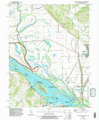
 1990 Meredosia1990 Print · USGSThe Illinois River valley and its surrounding farm towns are captured here in the 1990s. Trace the intricate rail lines of the Norfolk Southern Railway and find local landmarks like Diamond Grove Cem or the Meredosia National Wildlife Refuge.
 - 1991 Map of Louisiana, 1995 Print
 1991 Louisiana1995 Print · USGSLouisiana and the Mississippi riverfront are captured here in the early nineties, showcasing a storied Missouri river town. Researchers can trace family plots at Riverview Cem or locate old industrial sites like Quincy Junction and the local Quarry.
 - 1991 Map of Rockport, 1995 Print
 1991 Rockport1995 Print · USGSThe Mississippi River bottomlands near Rockport appear here in the early nineties, showing a complex network of levees and conservation lands. Trace local family history and rural geography through Brewster Cem, the Stillhouse, and The Sny.
 - 1993 Map of Ashburn, 1995 Print
 1993 Ashburn1995 Print · USGSThe Mississippi River bottomlands and bluffs of Missouri and Illinois are captured here in the early nineties. Researchers can trace family plots at Schindler Cem, locate the Mundy Landing site, or explore the winding banks of the Salt River.
 - 1993 Map of Hull, 1996 Print
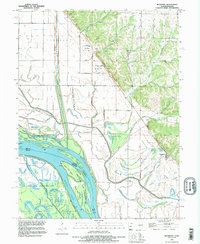
 1993 Hull1996 Print · USGSPike County settlements and the Mississippi floodplain are documented here in the early nineties. Genealogists and researchers can locate Hull Cem, trace the channel of The Sny, and find Lock and Dam No 22 on the riverbank.
 - 1993 Map of Pleasant Hill West, 1996 Print
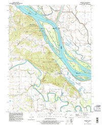
 1993 Pleasant Hill West1996 Print · USGSThe Illinois-Missouri borderlands appear in the mid-1990s as a highly engineered landscape of river islands, sloughs, and levees. Researchers can trace family history at Martinsburg Cem or study river navigation at Lock and Dam No 24 and The Sny.
 - 1993 Map of Hannibal East, 1996 Print
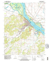
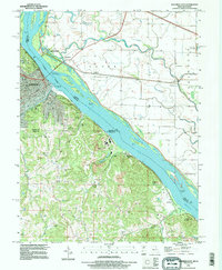 1993 Hannibal East1996 Print · USGSThe Mississippi River corridor near Hannibal comes to life in this mid-nineties survey of the Missouri-Illinois border. Genealogists and historians can trace Riverside Cem, the Mark Twain Cave, and old river settlements like Saverton and Monkey Run.
 - 1996 Map of Marblehead, 1998 Print
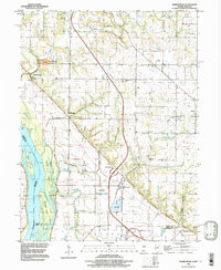 1996 Marblehead1998 Print · USGSThe Mississippi River bottomlands of Adams and Pike Counties are shown here in the 1990s as a landscape of levees and industrial quarries. Genealogists can trace family landmarks like Craigtown Cem and Bluff Hall while exploring the shifting banks of Schaffer Island.
 - 1998 Map of New Salem, 2001 Print
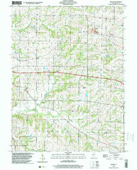
 1998 New Salem2001 Print · USGSNorthern Pike County at the end of the century reveals a landscape of rolling creeks and quiet townships. Genealogists can trace family roots at Staggett Cem or Gray Cem, while exploring the area near Maysville Station.
 - 1998 Map of Baylis, 2001 Print
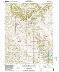
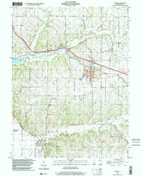
 1998 Baylis2001 Print · USGSPike County's rural townships and small settlements are mapped here in the late 1990s as the regional rail economy transitioned. Researchers can pinpoint numerous family burial grounds like Starkey Cem and Johnson Cem or trace the Norfolk and Western Railroad Grade.
 - 1998 Map of Griggsville, 2001 Print
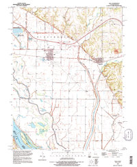
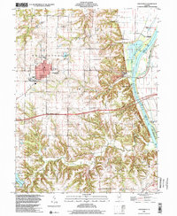 1998 Griggsville2001 Print · USGSIn the final years of the millennium, this area of Pike County shows the town of Griggsville atop the bluffs overlooking the Illinois River. Researchers can trace old transportation routes like the Old Grade and locate family landmarks such as Elledge Cem and the Holy Family Ch.
 - 1998 Map of Barry, 2002 Print
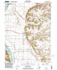
 1998 Barry2002 Print · USGSPike County, Illinois, is documented here in the late 1990s as the regional infrastructure around Barry evolved. Researchers can trace old family burial grounds like Woodruff Cem and Blair Cem or locate local landmarks like Weber Spring and the Gully Landing Strip.
 - 1998 Map of Florence, 2003 Print
 1998 Florence2003 Print · USGSIn the late nineties, the Illinois River valley south of Naples remained a landscape of protective levees and scattered upland hamlets. Researchers can trace numerous family burial sites like Exeter Cem and landmarks such as Browns Mound or the Norfolk Southern rail corridor.
End of results
Showing maps 1-13 of 13
Top cities of Pike County
- Pittsfield historical maps
- Barry historical maps
- Griggsville historical maps
- Pleasant Hill historical maps
- Atlas historical maps
- Montezuma historical maps
See more
Frequently asked questions
- What are the different types of historical maps available for Pike County?
- What is the oldest map of Pike County?
- Where can I purchase historical maps of Pike County for my home or office?
- Where can I download high-res historical maps of Pike County?
- Are there historical topographic maps available for Pike County?
- Is there historical aerial imagery available for Pike County?
- Where are historical maps of Pike County sourced from?