1980s Maps of Pike County, Illinois
Explore 20 historic maps of Pike County from the 1980s. These maps offer a rare glimpse into what life looked like during the 1980s — showing old roads, neighborhoods, homes, and landmarks that have changed or disappeared over time.
Whether you're researching your family's past, planning a metal detecting trip, or studying how Pike County's landscape evolved across the 1980s, these high-resolution maps are a powerful tool for exploring the history of this region.
- Focus on a specific era: All maps on this page are from the 1980s, giving you a focused view of this time period.
- See what’s changed: Compare century-old streets, trails, and buildings to today's modern landscape using overlays and satellite layers.
- Research with precision: Use these maps for genealogy, historical research, land use analysis, or educational projects.
- View, download, or print: Maps are fully viewable online in high resolution, and can be downloaded or printed for your own records.
Start exploring Pike County's history through authentic maps from the 1980s. This is your window into the past.
Pike County, IL maps
(20)- 1980 Map of Bedford, 1981 Print
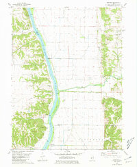 1980 Bedford1981 Print · USGSThe Illinois River valley in the early eighties shows a landscape of riverfront settlements and managed bottomlands. Genealogists and local researchers can locate Montezuma, Bedford, and several family burial sites including Clemmons Cem and Adams Cem.
 - 1980 Map of Perry East, 1981 Print
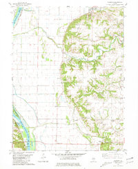
 1980 Perry East1981 Print · USGSPike and Brown Counties appear in the late 1970s as a landscape of interconnected creek forks and small farming hubs. Researchers can locate numerous family burial grounds like Calhoun Cem, Rusk Cem, and Woods Cem near the banks of Mc Kee Creek.
 - 1980 Map of Pearl East, 1981 Print
 1980 Pearl East1981 Print · USGSGreene County bottomlands and bluffs come alive in this early 1980s survey of the Illinois River valley. Genealogists can trace family burial sites like Likely Cem and Kinser Cem while historians follow the Illinois Central Gulf rail line through Hillview.
 - 1980 Map of Meredosia, 1981 Print
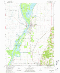 1980 Meredosia1981 Print · USGSThe Illinois River valley in the early 1980s reveals a landscape of massive levees, rail lines, and wetlands across four county borders. Researchers can trace family history at Oakland Cem or Fairview Cem and follow the Norfolk and Western tracks through Meredosia and Naples.
 - 1980 Map of Griggsville, 1981 Print
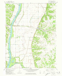
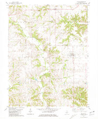
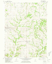
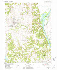 1980 Griggsville1981 Print · USGSPike County at the start of the 1980s reveals a landscape of bluff-side settlements and river commerce along the Illinois. Researchers can trace the rail corridor of the Norfolk and Western or locate local landmarks like Holy Family Ch and Griggsville Landing.
 - 1980 Map of Pearl West, 1981 Print
 1980 Pearl West1981 Print · USGSThe Pike and Calhoun county line comes alive in this late twentieth-century study of the ridges and hollows near the Illinois River. Genealogists and historians can trace family ties at McConnell Cem and Hess Cem or locate the site of Old Pearl.
 - 1980 Map of Florence, 1981 Print
 1980 Florence1981 Print · USGSThe Illinois River valley in the early 1980s shows a landscape of river-and-rail commerce and deep-rooted family history. Genealogists can trace numerous family-named landmarks including Hill-Crest Cem, Browns Mound, and West Rutledge Baker Cem.
 - 1981 Map of Fishhook
 1981 Fishhook1981 Print · USGSThe rural borderlands of Adams and Pike Counties are captured here in the early 1980s. Researchers can locate family burial plots and old country churches like Mound Prairie Ch, Winner Cem, and the settlement at Chestline.
 - 1981 Map of Milton
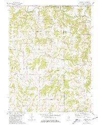
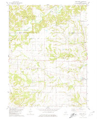
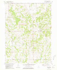
 1981 Milton1981 Print · USGSPike County settlements and rural cemeteries are extensively documented in the early 1980s. Researchers can locate numerous burial sites like Wills Cem and French Cem or trace landmarks such as East Pike High Sch.
 - 1981 Map of Perry West
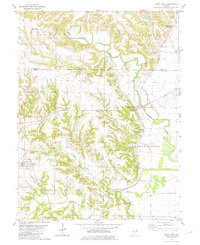
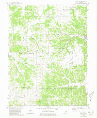
 1981 Perry West1981 Print · USGSThe borderlands of Brown and Pike County in the mid-1970s reveal a landscape of deep-rooted family farms and rural hamlets. Researchers can trace ancestral locations across numerous sites including Morrelville, Fairmount Ch, and the FISHHOOK GAS FIELD.
 - 1981 Map of New Salem
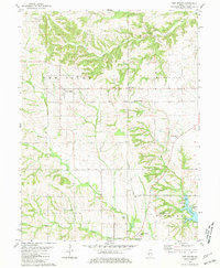 1981 New Salem1981 Print · USGSPike County's rural landscape is captured in the early 1980s as the Norfolk and Western line passed through New Salem. Researchers can trace family plots like Simpkins-Brown Cem and explore the development of Lake Pittsfield.
 - 1981 Map of Summer Hill
 1981 Summer Hill1981 Print · USGSPike County in the early eighties shows a landscape of upland townships and bottomlands along The Sny Cutoff. Researchers can trace early family sites at Worobles Cem and Taylor Cem or locate community landmarks like Black Oak Ch and New Hartford.
 - 1981 Map of Payson
 1981 Payson1981 Print · USGSSouthern Adams County in the early eighties reveals a landscape of wooded creek valleys and prairie farmsteads. Researchers can trace numerous local burial sites like Steward Cem and New Town Cem or locate rural landmarks such as the Krutmeier Landing Strip.
 - 1981 Map of Pittsfield
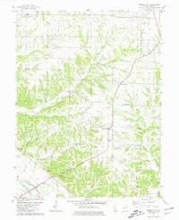
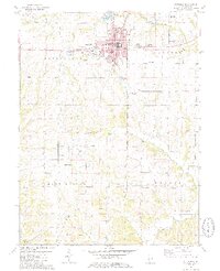 1981 Pittsfield1981 Print · USGSThe Pike County seat and its surrounding townships are shown here in the early eighties, capturing a landscape of small agricultural communities and rural burial grounds. Genealogists can locate numerous sites including Oakwood Cem, Tamsett Cem, and Martinsburg.2 unique versions available
 - 1981 Map of Richfield
 1981 Richfield1981 Print · USGSRichfield and Kingston were established rural centers in the early eighties as the Adams and Pike county line remained a landscape of family farms. Genealogists can trace local heritage through numerous sites like Klarner Cem, Steward Cem, and Potter Cem.
 - 1981 Map of Baylis
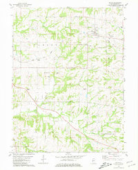 1981 Baylis1981 Print · USGSPike County in the early eighties shows a landscape of rail-dependent towns and dispersed family cemeteries. Genealogists can trace rural family roots at Starkey Cem or McWorter Cem, and follow the Old Railroad Grade near Baylis.
 - 1985 Map of Jerseyville
 1985 Jerseyville1985 Print · USGSThe confluence of the Illinois and Mississippi rivers defines this 1980s landscape of fertile bottomlands and rail-hub towns. Genealogists and historians can trace the foundations of communities like Jerseyville and White Hall alongside the Oak Grove Cem and St Mary Church.2 unique versions available
 - 1985 Map of Meredosia, 1988 Print
 1985 Meredosia1988 Print · USGSWest Central Illinois in the mid-eighties was a landscape of deep-rooted river towns and historic educational institutions. Genealogists and historians can trace family ties through Diamond Grove Cem, locate MacMurray College in Jacksonville, or study the river engineering at La Grange Lock and Dam.
 - 1986 Map of Quincy
 1986 Quincy1986 Print · USGSThe tri-state border region along the Mississippi River comes into focus during the mid-1980s. Researchers can trace the legacy of river towns and rail hubs like Quincy and Monroe City or locate landmarks such as Mount Olive Cem.2 unique versions available
 - 1986 Map of Mexico
 1986 Mexico1986 Print · USGSEast Central Missouri in the mid-eighties shows a landscape of steady agricultural towns and the expansive waters of Mark Twain Lake. Genealogists and historians can trace rail-side communities like Laddonia and Wellsville or locate family markers at Elwood Cem.2 unique versions available
End of results
Showing maps 1-20 of 20
Top cities of Pike County
- Pittsfield historical maps
- Barry historical maps
- Griggsville historical maps
- Pleasant Hill historical maps
- Atlas historical maps
- Montezuma historical maps
See more
Frequently asked questions
- What are the different types of historical maps available for Pike County?
- What is the oldest map of Pike County?
- Where can I purchase historical maps of Pike County for my home or office?
- Where can I download high-res historical maps of Pike County?
- Are there historical topographic maps available for Pike County?
- Is there historical aerial imagery available for Pike County?
- Where are historical maps of Pike County sourced from?