1980s Maps of Pittsfield, Illinois
Explore 4 historic maps of Pittsfield from the 1980s. These maps offer a rare glimpse into what life looked like during the 1980s — showing old roads, neighborhoods, homes, and landmarks that have changed or disappeared over time.
Whether you're researching your family's past, planning a metal detecting trip, or studying how Pittsfield's landscape evolved across the 1980s, these high-resolution maps are a powerful tool for exploring the history of this region.
- Focus on a specific era: All maps on this page are from the 1980s, giving you a focused view of this time period.
- See what’s changed: Compare century-old streets, trails, and buildings to today's modern landscape using overlays and satellite layers.
- Research with precision: Use these maps for genealogy, historical research, land use analysis, or educational projects.
- View, download, or print: Maps are fully viewable online in high resolution, and can be downloaded or printed for your own records.
Start exploring Pittsfield's history through authentic maps from the 1980s. This is your window into the past.
Pittsfield, IL maps
(4)- 1980 Map of Griggsville, 1981 Print
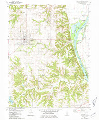 1980 Griggsville1981 Print · USGSPike County at the start of the 1980s reveals a landscape of bluff-side settlements and river commerce along the Illinois. Researchers can trace the rail corridor of the Norfolk and Western or locate local landmarks like Holy Family Ch and Griggsville Landing.
 - 1981 Map of New Salem
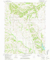 1981 New Salem1981 Print · USGSPike County's rural landscape is captured in the early 1980s as the Norfolk and Western line passed through New Salem. Researchers can trace family plots like Simpkins-Brown Cem and explore the development of Lake Pittsfield.
 - 1981 Map of Pittsfield
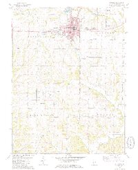 1981 Pittsfield1981 Print · USGSThe Pike County seat and its surrounding townships are shown here in the early eighties, capturing a landscape of small agricultural communities and rural burial grounds. Genealogists can locate numerous sites including Oakwood Cem, Tamsett Cem, and Martinsburg.2 unique versions available
 - 1985 Map of Meredosia, 1988 Print
 1985 Meredosia1988 Print · USGSWest Central Illinois in the mid-eighties was a landscape of deep-rooted river towns and historic educational institutions. Genealogists and historians can trace family ties through Diamond Grove Cem, locate MacMurray College in Jacksonville, or study the river engineering at La Grange Lock and Dam.
End of results
Showing maps 1-4 of 4
Top cities near Pittsfield
- Griggsville historical maps
- Pleasant Hill historical maps
- Atlas historical maps
- Montezuma historical maps
- Martinsburg historical maps
- Perry historical maps
See more
Frequently asked questions
- What are the different types of historical maps available for Pittsfield?
- What is the oldest map of Pittsfield?
- Where can I purchase historical maps of Pittsfield for my home or office?
- Where can I download high-res historical maps of Pittsfield?
- Are there historical topographic maps available for Pittsfield?
- Is there historical aerial imagery available for Pittsfield?
- Where are historical maps of Pittsfield sourced from?