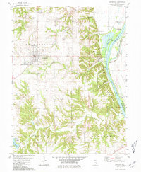
1980 Map of Griggsville
USGS Topo · Published 1981About this map
Griggsville serves as the primary hub of this west-central Illinois landscape, where the grid of the town site contrasts with the sharp ravines of Hatch Hollow and Napoleon Hollow leading toward the valley. The eastern edge of the quadrangle is defined by the Illinois River, where commercial and industrial activity is evidenced by a Quarry, a Pumping Station, and the river-crossing infrastructure of the Norfolk and Western railroad.
Find a feature on this map
41 named features on this map. Tap any name to fly to it.
Don’t see what you’re looking for? This feature index may not catch every label — zoom into the map to look around manually.
Map Details
Editions of this 1980 Griggsville Map
This is the sole edition of this map. No revisions or reprints were ever made.
Other maps of this area

1924 · Griggsville
USGS Topo · 1:62,500

1926 · Griggsville
USGS Topo · 1:62,500

1926 · Pittsfield
USGS Topo · 1:62,500

1926 · Mt Sterling
USGS Topo · 1:62,500

1928 · Meredosia
USGS Topo · 1:62,500

1929 · Mt Sterling
USGS Topo · 1:62,500

1931 · Meredosia
USGS Topo · 1:62,500

1948 · Quincy
USGS Topo · 1:250,000

1956 · Quincy
USGS Topo · 1:250,000
1975 · Meredosia SE
USGS Topo · 1:24,000