1980s Maps of Rock Island County, Illinois
Explore 6 historic maps of Rock Island County from the 1980s. These maps offer a rare glimpse into what life looked like during the 1980s — showing old roads, neighborhoods, homes, and landmarks that have changed or disappeared over time.
Whether you're researching your family's past, planning a metal detecting trip, or studying how Rock Island County's landscape evolved across the 1980s, these high-resolution maps are a powerful tool for exploring the history of this region.
- Focus on a specific era: All maps on this page are from the 1980s, giving you a focused view of this time period.
- See what’s changed: Compare century-old streets, trails, and buildings to today's modern landscape using overlays and satellite layers.
- Research with precision: Use these maps for genealogy, historical research, land use analysis, or educational projects.
- View, download, or print: Maps are fully viewable online in high resolution, and can be downloaded or printed for your own records.
Start exploring Rock Island County's history through authentic maps from the 1980s. This is your window into the past.
Rock Island County, IL maps
(6)- 1982 Map of Hillsdale
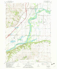 1982 Hillsdale1982 Print · USGSIn the early 1980s, the Rock River valley near Hillsdale remained a land defined by its winding sloughs and rural cemeteries. Genealogists and local historians can locate Mount Moriah Cem and Bethesda Cem, or trace the old rail lines serving Joslin.
 - 1982 Map of Erie NW
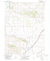 1982 Erie NW1982 Print · USGSWhiteside and Rock Island counties are shown in the early eighties as a landscape defined by industrial drainage and rail transport. Genealogists and local historians can locate Kingsbury Cem, Bethel Ch, and the winding Burlington Northern Railroad.
 - 1984 Map of Muscatine, 1985 Print
 1984 Muscatine1985 Print · USGSThe Mississippi River corridor and Iowa prairie meet in the 1980s, showcasing a landscape of river navigation and agricultural heartland. Genealogists and researchers can locate old schools and landmarks like Maharishi International University, Elm Grove Cem, and Lock & Dam No 16.2 unique versions available
 - 1984 Map of Davenport, 1985 Print
 1984 Davenport1985 Print · USGSThe Quad Cities and the eastern Iowa riverlands are captured in the mid-eighties as industry and conservation converged along the Mississippi. Genealogists and local historians can trace rural roots through Stender Church, Oxford Mills, and the Elmwood Cem burial grounds.2 unique versions available
 - 1984 Map of Aledo, 1985 Print
 1984 Aledo1985 Print · USGSThe Mississippi River borderlands and Illinois heartland are captured here in the mid-eighties as industry and agriculture overlap. Trace the Hennepin Canal, the historic Swedish colony at Bishop Hill, and the rail corridors of the Burlington Northern.
 - 1989 Map of Aledo
 1989 Aledo1989 Print · USGSWestern Illinois and eastern Iowa are shown here during the late twentieth century, when the river-and-rail economy still defined the Quad Cities and the surrounding prairie. Researchers can trace historic settlements like Bishop Hill and Millersburg alongside active routes like the Chicago Rock Island & Pacific RR.
End of results
Showing maps 1-6 of 6
Top cities of Rock Island County
- Moline historical maps
- Rock Island historical maps
- East Moline historical maps
- Silvis historical maps
- Milan historical maps
- Hampton historical maps
See more
Frequently asked questions
- What are the different types of historical maps available for Rock Island County?
- What is the oldest map of Rock Island County?
- Where can I purchase historical maps of Rock Island County for my home or office?
- Where can I download high-res historical maps of Rock Island County?
- Are there historical topographic maps available for Rock Island County?
- Is there historical aerial imagery available for Rock Island County?
- Where are historical maps of Rock Island County sourced from?