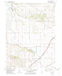
1982 Map of Erie NW
USGS Topo · Published 1982About this map
Meredosia Bottoms dominates the western landscape of this early 1980s survey, defined by an intricate network of drainage infrastructure designed to manage the low-lying terrain near the Whiteside and Rock Island County boundary. The map reveals a heavily engineered hydrology, where the Meredosia Ditch, Smith Ditch, and West Branch Diversion Ditch cut across the alluvial flats. This water management system supported the agricultural development of the Newton, Albany, Coe, and Erie townships.
Find a feature on this map
40 named features on this map. Tap any name to fly to it.
Don’t see what you’re looking for? This feature index may not catch every label — zoom into the map to look around manually.
Map Details
Editions of this 1982 Erie NW Map
This is the sole edition of this map. No revisions or reprints were ever made.
Other maps of this area

1891 · Clinton
USGS Topo · 1:62,500

1892 · Goose Lake
USGS Topo · 1:62,500

1892 · Leclaire
USGS Topo · 1:62,500

1893 · Leclaire
USGS Topo · 1:62,500

1894 · Goose Lake
USGS Topo · 1:62,500

1894 · Clinton
USGS Topo · 1:62,500

1899 · Clinton
USGS Topo · 1:125,000

1949 · Port Byron
USGS Topo · 1:24,000

1950 · Port Byron
USGS Topo · 1:24,000

1952 · Erie
USGS Topo · 1:62,500