1930s Maps of Stephenson County, Illinois
Explore 4 historic maps of Stephenson County from the 1930s. These maps offer a rare glimpse into what life looked like during the 1930s — showing old roads, neighborhoods, homes, and landmarks that have changed or disappeared over time.
Whether you're researching your family's past, planning a metal detecting trip, or studying how Stephenson County's landscape evolved across the 1930s, these high-resolution maps are a powerful tool for exploring the history of this region.
- Focus on a specific era: All maps on this page are from the 1930s, giving you a focused view of this time period.
- See what’s changed: Compare century-old streets, trails, and buildings to today's modern landscape using overlays and satellite layers.
- Research with precision: Use these maps for genealogy, historical research, land use analysis, or educational projects.
- View, download, or print: Maps are fully viewable online in high resolution, and can be downloaded or printed for your own records.
Start exploring Stephenson County's history through authentic maps from the 1930s. This is your window into the past.
Stephenson County, IL maps
(4)- 1932 Map of Pecatonica
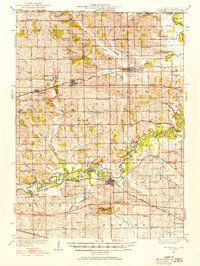 1932 Pecatonica1932 Print · USGSThe Pecatonica River valley at the start of the 1930s shows a landscape of busy rail towns and a remarkable density of rural schoolhouses. Genealogists can locate family landmarks like Woodruff Corners, Pioneer Cem, and the Twelvemile Grove Ch.3 unique versions available
 - 1936 Map of Pecatonica
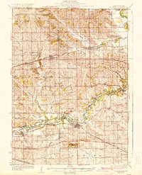 1936 Pecatonica1936 Print · USGSNorthern Illinois agriculture and river life thrive in the 1930s along the winding Pecatonica River and the Wisconsin border. Genealogists can trace hundreds of rural homes and a dense grid of schoolhouses including College Sch, Irish Grove Sch, and Twelvemile Grove Ch.2 unique versions available
 - 1937 Map of Lena
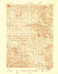 1937 Lena1937 Print · USGSNorthwestern Illinois at the close of the Depression era shows a landscape dense with rural life and rail activity. Genealogists can trace family roots through numerous landmarks like Chelsea Ch, Blair Cem, and the Blackhawk Battlefield and Monument.
 - 1939 Map of Freeport
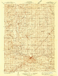 1939 Freeport1939 Print · USGSStephenson County in the late thirties is a landscape of thriving rail junctions and rural school districts. Genealogists can trace family roots through dozens of local landmarks like St James Cem, Browns Mill, and small hubs like Orangeville or Pearl City.2 unique versions available
End of results
Showing maps 1-4 of 4
Top cities of Stephenson County
- Freeport historical maps
- Lena historical maps
- Loran historical maps
- Rock Grove historical maps
- Oneco historical maps
- Florence historical maps
See more
Frequently asked questions
- What are the different types of historical maps available for Stephenson County?
- What is the oldest map of Stephenson County?
- Where can I purchase historical maps of Stephenson County for my home or office?
- Where can I download high-res historical maps of Stephenson County?
- Are there historical topographic maps available for Stephenson County?
- Is there historical aerial imagery available for Stephenson County?
- Where are historical maps of Stephenson County sourced from?