1970s Maps of Stephenson County, Illinois
Explore 10 historic maps of Stephenson County from the 1970s. These maps offer a rare glimpse into what life looked like during the 1970s — showing old roads, neighborhoods, homes, and landmarks that have changed or disappeared over time.
Whether you're researching your family's past, planning a metal detecting trip, or studying how Stephenson County's landscape evolved across the 1970s, these high-resolution maps are a powerful tool for exploring the history of this region.
- Focus on a specific era: All maps on this page are from the 1970s, giving you a focused view of this time period.
- See what’s changed: Compare century-old streets, trails, and buildings to today's modern landscape using overlays and satellite layers.
- Research with precision: Use these maps for genealogy, historical research, land use analysis, or educational projects.
- View, download, or print: Maps are fully viewable online in high resolution, and can be downloaded or printed for your own records.
Start exploring Stephenson County's history through authentic maps from the 1970s. This is your window into the past.
Stephenson County, IL maps
(10)- 1971 Map of Orangeville, 1974 Print
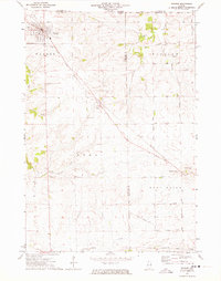
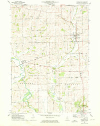 1971 Orangeville1974 Print · USGSNorthwest Illinois sits at the edge of the Wisconsin border in the early seventies, where the Pecatonica River meets a network of rail-side villages. Researchers can locate many family landmarks including Silent Hill Cemetery, Richland Salem Church, and the winding Illinois Central Gulf Railroad.
 - 1971 Map of Pearl City, 1974 Print
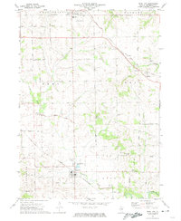 1971 Pearl City1974 Print · USGSPearl City and the surrounding Stephenson County townships are captured here in the early seventies as a mature rail-and-road landscape. Genealogists and local historians can locate numerous rural burial grounds like Highland Cem and Grace Cem, or trace the path of the Chicago and North Western railroad.
 - 1971 Map of Lena, 1974 Print
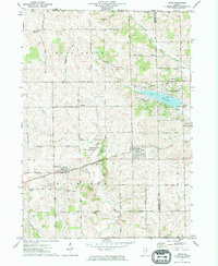
 1971 Lena1974 Print · USGSNorthwest Illinois in the early seventies shows a landscape of river valleys and rail hubs near the state line. Genealogists can trace family sites at Christian Hollow Cem and Manny Cem or explore the growth of Lena and Winslow.2 unique versions available
 - 1971 Map of Freeport West, 1974 Print
 1971 Freeport West1974 Print · USGSFreeport's western expansion meets the rolling farmland of Stephenson County in the early seventies, as the Pecatonica River winds through Harlem township. Researchers can trace historic family burial sites at Hart Cem and Grandview Cem or locate the original campus layout of Highland Community College.2 unique versions available
 - 1971 Map of Dakota, 1974 Print
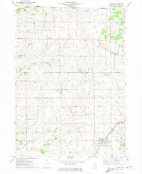 1971 Dakota1974 Print · USGSNorthern Illinois farmland near the Wisconsin border is captured here in the early 1970s. Local researchers can locate family landmarks like Bethel Ch, the Farm School, and the tracks of the Chicago Milwaukee St Paul and Pacific railroad.
 - 1971 Map of Freeport East, 1974 Print
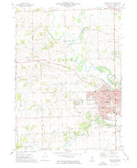
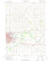 1971 Freeport East1974 Print · USGSFreeport is shown at its early 1970s peak as a regional center of rail, river, and industry. Genealogists and local historians can trace family locations near Winneshiek, the Silver Spring Cemetery, and schools like St. Stephens School.2 unique versions available
 - 1971 Map of Ridott, 1974 Print
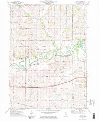 1971 Ridott1974 Print · USGSStephens and Winnebago counties are captured here in the early 1970s, as the Pecatonica River valley remained a landscape of quiet agriculture and rail transport. Researchers can find numerous country landmarks like Brick School, Ridott Center Cem, and the settlement of Evarts.2 unique versions available
 - 1971 Map of Davis, 1974 Print
 1971 Davis1974 Print · USGSNorthern Illinois at the start of the seventies reveals a landscape of growing lake communities and rail-side villages. Genealogists can trace family names through Pioneers Cem, St Pauls Ch, and the rural Farm School.
 - 1971 Map of Kent, 1974 Print
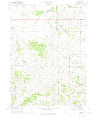 1971 Kent1974 Print · USGSThe rural borderlands of Jo Daviess and Stephenson counties are shown here during the early 1970s, focused on the rail-side settlement of Kent. Researchers can trace old family sites and local landmarks like St Pauls Ch, Blair Cem, and Morseville.
 - 1971 Map of Warren, 1974 Print
 1971 Warren1974 Print · USGSThe Illinois-Wisconsin borderlands and Jo Daviess County countryside are captured here in the early 1970s. Trace family roots at St Anns Cem and Waddams Grove Cem, or follow the Illinois Central Gulf rail line past the Fairground.
End of results
Showing maps 1-10 of 10
Top cities of Stephenson County
- Freeport historical maps
- Lena historical maps
- Loran historical maps
- Rock Grove historical maps
- Oneco historical maps
- Florence historical maps
See more
Frequently asked questions
- What are the different types of historical maps available for Stephenson County?
- What is the oldest map of Stephenson County?
- Where can I purchase historical maps of Stephenson County for my home or office?
- Where can I download high-res historical maps of Stephenson County?
- Are there historical topographic maps available for Stephenson County?
- Is there historical aerial imagery available for Stephenson County?
- Where are historical maps of Stephenson County sourced from?