1990s Maps of Stephenson County, Illinois
Explore 2 historic maps of Stephenson County from the 1990s. These maps offer a rare glimpse into what life looked like during the 1990s — showing old roads, neighborhoods, homes, and landmarks that have changed or disappeared over time.
Whether you're researching your family's past, planning a metal detecting trip, or studying how Stephenson County's landscape evolved across the 1990s, these high-resolution maps are a powerful tool for exploring the history of this region.
- Focus on a specific era: All maps on this page are from the 1990s, giving you a focused view of this time period.
- See what’s changed: Compare century-old streets, trails, and buildings to today's modern landscape using overlays and satellite layers.
- Research with precision: Use these maps for genealogy, historical research, land use analysis, or educational projects.
- View, download, or print: Maps are fully viewable online in high resolution, and can be downloaded or printed for your own records.
Start exploring Stephenson County's history through authentic maps from the 1990s. This is your window into the past.
Stephenson County, IL maps
(2)- 1998 Map of Freeport West, 2000 Print
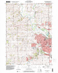 1998 Freeport West2000 Print · USGSStephenson County at the turn of the millennium shows the growth of Freeport alongside established rural hamlets. Researchers can trace family sites at Martin Cem, find early schools like Empire Sch, or follow the Pecatonica River past Scioto Mills.
 - 1999 Map of Freeport East, 2000 Print
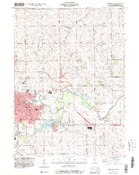 1999 Freeport East2000 Print · USGSFreeport and the surrounding Stephenson County farmland are captured here in the late 1990s as the city expanded toward the Pecatonica River. Researchers can trace family history at Lancaster Cem, locate the old Brick School, or find vanished landmarks like Browns Mill.
End of results
Showing maps 1-2 of 2
Top cities of Stephenson County
- Freeport historical maps
- Lena historical maps
- Loran historical maps
- Rock Grove historical maps
- Oneco historical maps
- Florence historical maps
See more
Frequently asked questions
- What are the different types of historical maps available for Stephenson County?
- What is the oldest map of Stephenson County?
- Where can I purchase historical maps of Stephenson County for my home or office?
- Where can I download high-res historical maps of Stephenson County?
- Are there historical topographic maps available for Stephenson County?
- Is there historical aerial imagery available for Stephenson County?
- Where are historical maps of Stephenson County sourced from?